Aqua Map - Mobile Chartplotter Reviews

Aqua Map - Mobile Chartplotter Reviews

Published by on 2023-12-16

About: An app to satisfy all your Fishing and Boating's needs, developed with the help
of expert boaters. Download the best up-to-date Nautical Charts to safely enjoy
the new boating season.


About Aqua Map


What is Aqua Map? The Fishing and Boating app is designed to cater to all the needs of fishing and boating enthusiasts. The app is developed with the help of expert boaters and offers the latest Nautical Charts to ensure safe boating. The app can transform your device into a real ChartPlotter and offers a range of features to plan and navigate your routes and tracks.


Features


- Optimized for both iPhone and iPad

- Download charts on the device for offline use

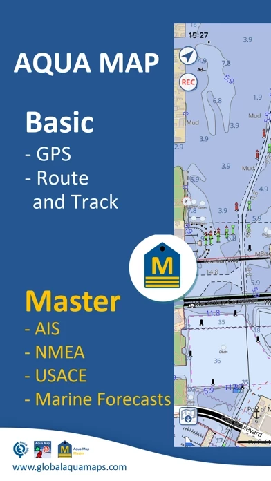
- Plan and navigate routes and tracks with real-time information

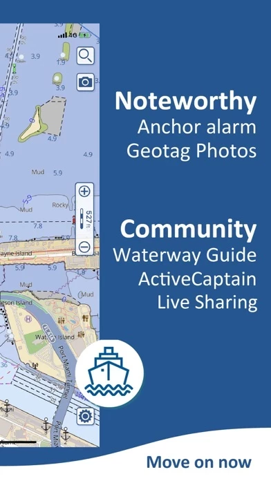
- Anchor alarm with advanced configuration

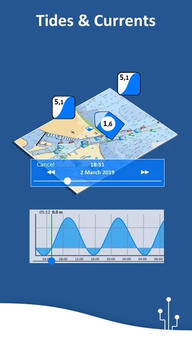
- Tide and current predictions and simulations (North America and Australia)

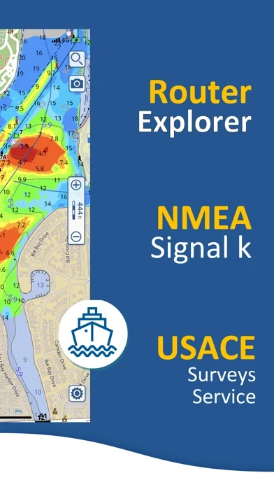
- Overlay USACE surveys and USCG List of lights on your charts (only US)

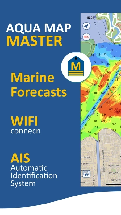
- Access the last marine forecasts (wind, waves, currents, and weather)

- Access more than 1800 weather buoys to get real-time weather conditions

- Share and load tracks, markers, and routes (KMZ and GPX)

- Connect to your friends using the Live Sharing function

- ActiveCaptain and Waterway Guide community integration

- Connect your NMEA devices through WiFi

- Display AIS info from external devices with automatic collision detection

- Powerful search with advanced settings

- Overlay satellite images on your map

- Fully support Light/Dark aspect

- Measure distances on the map

- Check all the bridges, hazards, and best fuel prices along your route

- Works perfectly in iPad multi-screen mode

- Optimized battery usage

- Aqua Map uses only official Nautical charts with depth contours, buoys, lights, etc.

- Plan your trip, insert and edit waypoints

- Navigate your route and your track (NEW) to monitor distance, time (ETA), and direction toward your next waypoint or your final destination

- Anchor alarm to check your GPS position against your anchor position previously defined

- Tides and currents prediction for more than 7500 stations in US, Canada, Bahamas & Australia

- Share your favorite markers on Facebook or send an email with your last daily track

- Live Sharing to exchange data with the Aqua Map community and follow your favorite users on the screen

- ActiveCaptain to join the community of more than 100.000 boaters who write reviews, update data and provide up to date hazard information

- Waterway Guide to access marinas, hazards, anchorages, bridges, free docks, and much more to cover the entire US coastline

- Aqua Map Master to access the last marine forecasts (wind, waves, currents, and weather), connect your NMEA (and SignalK) devices through WiFi, display the AIS targets on the map with automatic collision detection, display the last USACE surveys and the last USCG List of Lights (only US), and consult the Route Explorer with anchorages, bridges, hazards, marinas, and best fuel prices (now available also for tracks)

- Two types of purchases: Unlimited and Subscription.


Overall User Satisfaction Rating


Positive experience
52.2%

Negative experience
47.8%

Neutral
41.6%

~ from Justuseapp.com NLP analysis of 9,206 combined software reviews.

Key Benefits of Aqua Map

- Lets you take trips before you actually do it for real

- Works ok on an old iPhone 6 Plus

- Got us in safely to Lahaina

- Features are great with the along route info on bridges, fuel stops etc

- USACE sonar survey overlay is an amazing tool


21 Aqua Map Reviews

4.7 out of 5

By


Love It

I guess I’m a bit strange but I’ve always loved maps! AquaMap rocks! It lets me take trips before I actually do it for real! So awesome!
Now we finally got our boat and I’ve been using this each time we have gone out. It’s invaluable to have when sometimes the water level is so low and if you are not paying attention to the map, you can run a ground. Many times it’s not about staying the middle of the ICW, you have to pay close attention to where you are at!
I love AquaMap and how I’ve been able to plan all our trips making sure we are safe and enjoying the waterways!
I”m also very impressed that anytime I’ve asked a question, I’ve gotten a real answer, not a bot sending me links.
Great job!


By


Best one. Fast. Free. Easy. Low Battery Impact

Basic plotter I use in Mid-Chesapeake Bay. And I tried a bunch of them. This is the best by far. Even works ok on an old iPhone 6 Plus. I wound up paying the $4.99 for an extra map. Some won’t have to. Otherwise you have to delete and download the next area if on a long transport. I spend lots of time where two map grids meet so I really need two areas. They give you one area of a map grid at a time free. Total bill: $4.99 for the plotter I use more than anything. Again, the one free map you get will work for most people. Best money I’ve spent boating... if there is such a thing!


By


Emergency download

On our way to Lahaina from Oahu, we got beat up and had an electrical failure and lost our GPS, amongst many other things. It was Hectic and was about midnight next to Lanai. I downloaded AquaMap, got the free map at Lahaina, which has a tiny entrance with many mooring balls before the first buoy marker. This free app got us in safely. 75’ Sunseeker Yacht. I absolutely love AquaMap. I will download AquaMap for future trips, but my only question, is if I download it to my iPhone, can I also use AquaMap on my IPad without having to pay a separate subscription for my two devices. Hope to hear from you. Mahalo. Highly recommend.


By


Tremendous Customer Support

I wrote a less-than-desirable review a few weeks ago. I was contacted by AM and they remained engaged until they had resolved all of my issues…..all of which were MY issues, not issues of AquaMap . I now have the most current version correctly installed and I am delighted with every aspect of AquaMap . I am using AquaMaps to navigate the ICW and near off-shore runs. The stress level at the helm has dropped significantly simply because I now have access to immediate, accurate, and actionable information heretofore unavailable on any app anywhere. Thank you Aqua Map!


By


Purchased but couldn’t use

At the recommendation of a fellow cruiser, I purchased an annual subscription for the Bahamas as a trial. I was able to use it for a short period of time and then kept getting a message that the tutorial period was over. My only thought was that I needed an internet connection to validate my subscription. If that is the case, AquaMap is useless because while cruising, internet access is not reality. Also because I was in the Bahamas, sorting out the problem was not possible. Now back in the US, I want to know what went wrong before purchasing US charts.


By


Game changer

The absolute best app that I’ve found so far for my boating needs. Having used AquaMap up and down the eastern coast and Bahamas I can highly recommend. this app master with a NEMA gateway such as Vesper AIS makes critical information available from anyplace on the vessel.
Information equals safety and having that at a glance, for me, is a sound investment in safety. Active captain data overlaid on charts makes using AquaMap a must have for planning and on tbr fly changes when finding dockage or anchorages.

To top it off support has been wonderful with any questions I’ve had


By


Great for Navigating the Hudson

Looking for a navigation app to help me on my first trip on the Hudson River. I have a runabout without any electronics so thought I’d try finding an app that would be fun to try and hopefully be of some help. I used it for the first time on the water and it worked flawlessly in helping me keep in the main channel. Seemed to be very accurate in marking the hazards and all of the channel markers that I saw along the way. Worked great for me and made my trip much more enjoyable and I believe, safer.


By


Disappearing charts, but great features

AquaMap has become my go to after losing Garmin BlueChart. The features are great with the along route info on bridges, fuel stops etc and the USACE sonar survey overlay is an amazing tool! BUT, despite ensuring the button in settings is off for delete charts in case of low available space my charts continue to disappear from two devices, but more obvious on my phone than tablet. Wrote to tech support and was dismissed as the button being my issue. It is certainly not on and I continue to have my charts disappear or require downloading 4-5 times before the tiles stop showing update in the corner. AquaMap is on track to be great, but is currently unreliable.


By


The best!

I use iNavX and Aqua Map. One uses raster charts and the other uses vector charts. They are the best of the best (I also have a Garmin dedicated chartplotter). Of the two, Aqua Maps is easier to use, gives more information (especially with the USACE overlays and the Active Captain data), and is less expensive to load up with charts that cover the whole US and Canada.

Update: After several more years and a few thousand more miles, this app is still my favorite.


By


Best app

If you are a boater you need to have AquaMap. AquaMap has everything you need as a builder. You could see all of the maps if you just pay five dollars you get to see everything in your area. I recommend this to all boaters and even if you are not a boater and just want to learn more about the water you should definitely get AquaMap or recommend to anybody.


By


Charts disappear from iPad

I am on an extended cruise in the Bahamas. I bought the full Explorer Chart Kit for Aqua Maps and installed it in my iPad as a secondary planning tool. I emphasize secondary as it can’t be trusted as a primary for any offshore sailing.
Unexpectedly, three times in the past two weeks all of my charts have disappeared with the message o must be connected to the internet. I’ve then had to reload all of the charts.
This is dangerous. Internet is spotty on these parts and there is no cell service if you are further than 10 miles offshore. Aqua Maps needs to fix this serious safety problem!


By


Good app but tracking is not as good as competitors

Good app; however tracking polling rate is too slow, when maneuvering in tight areas you will have the line cut across objects and land instead of following the actual track of the boat. I wish there was a setting to increase or decrease the polling time. For ocean passages slow poll rate is great, saves on gpx size among other things, but for coastal navigation need to be able to increase polling time to reflect frequent course changes.


By


Active Captain Included

I loaded AquaMap and purchased charts because SEAiq lost access to Active Captain after the Garmin acquisition. I am delighted to once again have offline access to Active Captain data. It is limited, though. One cannot create new POI’s or add reviews without being directed to the Garmin Active Captain website. Please, developer, add these features.
The nav app itself is very good, although screens are slow to load, even on my new iPad Pro.


By


OK not great

Use AquaMap for Explorer charts. While the price for these charts is good, the detail leaves a lot to be desired since the charts are Raster scans instead of Vector. This means you are restricted to meter depths and no additional detail when zooming in. The Explorer data is good for suggested routes and locations of services cruisers are interested in such as anchorage data, grocery stores, dinghy docks, etc. AquaMap interface is also not intuitive leading me to go through the tutorial often to find how to perform simple navigation tasks.

Buy AquaMap for the chart data, not the interface.


By


Great For Checking

While I generally use dedicated chart plotters as the primary means of navigation, I do use this application to double check my primary systems. I also frequently use the application for planning trips using it’s access to active captain. I have a large memory capacity on my Iphone6s, and have 8 gig of charting data stored on the phone. The application seems to manage this large data base without any issues.


By


Good Boating Chart

Actually a really good boating chart. I always find myself using this over the other apps. I sail around the San Francisco Bay Area. The company also seems to care about its product and it’s users. Customizable useful features. I verrrry rarely write reviews, last one was forever ago. So I’m usually only writing if it’s really good or really bad. This is on the good side.


By


Head and Shoulders Above the Others

Aqua Map is THE mobile app that should be on a tablet on a Ram mount at every helm and on your smart phone. Please go through the built in tutorial. Until I did that, I did not understand just how capable AquaMap is. App is free, best approach to pricing charts. Buy charts (I got “forever” updates) and use on up to five devices. Nobody else even comes close in value. Too many features to list.


By


Best app for mariners

this app and the USACE overlays is a must have for any mariner. With the added value of integration with the popular Waterway Guides and ActiveCaptain, this integrated tool will save you from grounding, provide up to the moment tide and current info and offer Marina and fuel solutions all along your route.

I cannot see a reason to NOT have this important tool. As a USCG Auxiliary Vessel Examiner, I tell every boater I interact with to consider it as part of their safety gear.

Capt Pat, M/V Hail Mary


By


Simple and easy for weekender

I suspect this is a very powerful app. However this is not what I was looking for as I am a weekend sailor and wanted a simple navigational program for sailing the Chesapeake. Tried several other programs that were way too complicated and expensive. This this one was easy to install and easy to use and very affordable. Perfect for what I needed for a week of sailing on vacation.


By


Does well

I have used this program for thousands of miles of boat trips. It has excellent charts, great search engine and access to useful reviews. The only thing missing is routing for estimates of time and distance of trips. I have to use Navionics Boating for that function, though Aquamaps beats Navionics in all other categories.


By


Maps not coming up

My wife and I recently purchased AquaMaps along with the maps for the Bahamas. We were on a leg of our journey and when I tried to zoom in on the maps,it said maps not downloaded. I waited until we were close to land and downloaded just that section again,but once again,it said the maps weren't downloaded. So we ended up using Navionics maps which are notoriously inaccurate in the Bahamas.


By


Active Captain missing data

I use AquaMap primarily for access to Active Captain. It seems like a good replacement for Blue Charts which is no longer available. It works very well for finding Active Captain reviews - the charts are clear and nicely detailed, it's easy to use - unfortunately, not all the Active Captain data is displayed. For anchorages, it is missing the ratings section and the sections called Dock, and Services. If it had the missing data I would give it five stars.


By


Great customer support

Had issues sharing purchased charts across multiple devices. Enrico was very patient walking me through the troubleshooting process and resolving the issue. Great product! Especially like the AIS WiFi integration as well as the ability to submit reviews to ActiveCaptain within AquaMap .


By


Wow this is a perfect app for my region in Alaska

I have fished and hunted my whole life in Alaska. I tap on a region and download it. I live on an island in Alaska , only way to get in and out is by plane or boat ! AquaMap is perfect for my region or any region in Alaska for that matter. Thank you for making an app available to people who live in the areas in America that are off the charts!


By


Use for Active Captain access and planning

Each app has its strong points. I use AquaMap mostly for planning and for AC access. In some areas, like in the USA AND Canada I would feel OK using it for navigation. But no app is completly perfect and this is a lot of bang for the buck. I use it a lot, more than I thought I would.


Karen S Moser   2 years ago


Maps moving really slow since latest update.


Is Aqua Map Safe?


Yes. Aqua Map - Mobile Chartplotter is very safe to use. This is based on our NLP (Natural language processing) analysis of over 9,206 User Reviews sourced from the Appstore and the appstore cumulative rating of 4.7/5 . Justuseapp Safety Score for Aqua Map Is 52.2/100.


Is Aqua Map Legit?


Yes. Aqua Map - Mobile Chartplotter is a totally legit app. This conclusion was arrived at by running over 9,206 Aqua Map - Mobile Chartplotter User Reviews through our NLP machine learning process to determine if users believe the app is legitimate or not. Based on this, Justuseapp Legitimacy Score for Aqua Map Is 93.8/100..


Is Aqua Map - Mobile Chartplotter not working?


Aqua Map - Mobile Chartplotter works most of the time. If it is not working for you, we recommend you excersise some patience and retry later or Contact Support.


Pricing Information

**Pricing data is based on average subscription prices reported by Justuseapp.com users..

- Unlimited: $24.99 (one-time purchase)

- $9.99/year (auto-renewable)


How was your experience with Aqua Map - Mobile Chartplotter? Post a Review

Leave a comment:


Alternatives