BaseMap: Hunting GPS Maps Reviews

BaseMap: Hunting GPS Maps Reviews

Published by on 2023-08-19

About: ***Now the Official Hunting App of the Bone Collector Brotherhood*** BaseMap is
the only outdoor app you will ever need. Turn your phone into a GPS and compass
to map your outdoor adventures and interact with the BaseMap community.


About BaseMap


What is BaseMap? The BaseMap app is an outdoor app that can be used as a GPS and compass to map outdoor adventures. It allows users to navigate to trailheads, favorite places, markers, or anything they need to locate with its powerful search and GoTo features. The app also has an outdoor journal feature that allows users to capture, log, and share all their outdoor adventures with the BaseMap community. Additionally, the app has a harvest log, Huntwind, and weather center, offline GPS and tracking, Geardrop, in-app 3D satellite imagery, Google Earth integration, and map layers.


Features


- Mobile GPS that allows users to know their exact location even without cellular or WiFi service

- XDR (Exact Direction & Range) Navigation Tool that immediately shows the exact distance between the user and their desired destination

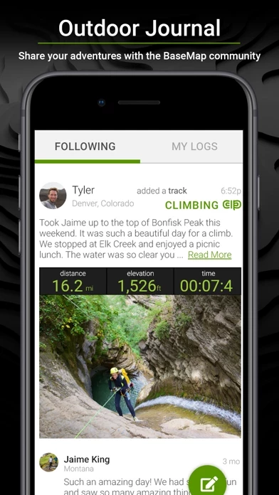
- Outdoor Journal that allows users to capture, log, and share all their outdoor adventures with the BaseMap community

- Harvest Log that allows users to log their hunts as detailed as they'd like

- Huntwind & Weather Center that provides wind forecast to better plan the hunt and know the exact day and time to hunt a particular stand

- Offline GPS and Tracking that allows users to cache maps for offline use and use anywhere, even without service

- Geardrop that allows users to drop their marker closest to the GearDrop marker and win free gear

- In-App 3D Satellite Imagery that allows users to see the terrain from every angle

- Google Earth Integration that allows users to export markers and view them right in Google Earth

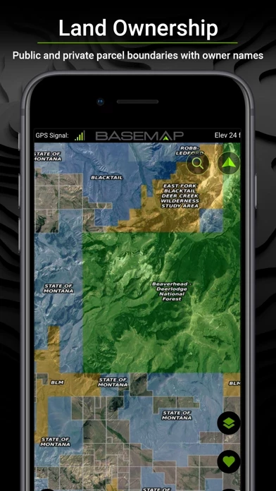
- Map Layers that include over 700 layers and growing, nationwide color-coded Govt lands, nationwide private parcel boundaries & owner names, water depths for East coast, West, Coast, Gulf coast, & over 4,000 U.S. lakes, nationwide hiking trails, nationwide wildfires & timbercuts, nationwide wilderness & roadless areas, state-specific hunting layers including hunting unit boundaries, private hunting opportunities, WMA’s & more, and multiple topography & satellite imagery basemap options

- Better Experience that includes nationwide plans so users never have to be restricted to just one state, fastest layer rendering speed, and sync all map data between the phone and the BaseMap web application

- Subscriptions that include Basic (Free), Pro ($9.99/mo or $34.99/yr), and Hunting Research ($9.99/yr) with different features and benefits.


Overall User Satisfaction Rating


Negative experience
52.0%

Positive experience
48.0%

Neutral
32.2%

~ from Justuseapp.com NLP analysis of 8,175 combined software reviews.

Key Benefits of BaseMap

- Look up property lines and who owns a property

- Highly detailed maps

- Ability to draw shapes to see how a project will fit

- Ability to cache and save an area for offline use

- Short and helpful online videos


20 BaseMap Reviews

4.7 out of 5

By


App is good but some issues

Overall, I like both BaseMap and desktop versions. They should work to improve the quality of the offline maps. More frustrating is that they still are trying to sell their Research Data add-on product despite them knowing that it is unmaintained and way outdated. For example, it is March 2022, and they still only have hunting data (harvest rates, etc.) up through the 2019 season. Also, their season date info is still only from 2020. I purchased this last year and was a complete waste of $10 since the data was old, and when I asked them about it, I got the canned “we’re sorry” response. How about not selling a service that you cannot support? They stated that they only download from Eastman’s data once per year. Ok…so why not download when you know they’ll have more data. But even that is not true because they are still 2 years behind! And yes this is the case for ALL states and regions…I checked. Instead of selling an unusable product just to have it listed as a feature of their app vs competitors, they should make sure that it provides value first.


By


Very impressed!!

I’ve had this app for about a month. I started with the free version, then upgraded to Pro. Being able to look up a property line or who owns a property is something I use on a weekly basis. I used it today for a friend to determine who owned a neighboring property so he could ask permission to track a deer.
Topo maps are great to scout without the groundwork (although I love the groundwork!). I can mark locations to keep track of where my trail cams are set or I can mark summer weed beds for winter ice fishing. I can also access water depths for lakes, which will also help me find drop offs for fishing.
The load time for parcel ownership and boundary lines is much quicker than other apps I’ve used.
I measured a 64 yard shooting distance across a pond, which was accurate when double checked with a range finder.
I’ve used other mapping apps, and I’ve got to say I’m impressed with the features this app has to offer. I still have a lot to learn within BaseMap , but so far I am impressed and highly recommend it!


By


Must have for serious hunters

I have been using this app for a while now and I cannot day enough good things about it. The level of quality in the maps is superior to anything I’ve found to be currently available. On a recent mule deer hunt I can confidently say that I would not have filled my tag without this app. Not only did we e-scout all our areas prior to the hunt but more importantly we used it for stalk planning. Using the highly detailed maps, we were able to place a marker where the deer was laying and then use Huntwind to plan our approach. That combination turned out to be highly effective as we were able to complete several stalks to the exact point the deer were without blowing them out. If you hunt or do anything outdoors, make the small investment. You will not regret it.


By


Simply AMAZING!

For years I have been looking for a way or an app so that I could view boundary lines in real time and not just wonder where I was in relationship to them. BaseMap solves that and so much more.

I have been searching for land for the past few years to fit the house that I’m looking to build. Not only will BaseMap allow you to measure the distance of the boundary lines, you can also draw shapes on it to see how your home or project will fit on it.

Another handy feature is the ability to cache and save an area so that when you’re off-line you have a way to view and use.
The online videos are short and extremely helpful to get using BaseMap in less than five minutes.

The only drawback I have found after using for a week is that some of the land ownership information is a bit out of date, sometimes as much as four years. You are not supposed to have access to this information in the basic free version however when you use the cache map you can see it, that’s how I know. Also read other reviews That mentioned the same issue. Not a huge concern for me and considering I’m using the basic, free version.
In summary, I just can’t say enough good things about BaseMap period. What have you got to lose.....try it!


By


$10 app more accurate than 30k worth lawyers & surveyors

My family forced the auction of my father’s estate this year. The tax assessors office thought it was 45 acres more and the lawyers billed us thousands for a land abstract and agreed with the assessors number. I tried to tell them it was short but nobody listened to me or BaseMap. They auctioned the land & the buyer had it surveyed twice, which we also had to pay for. All together we lost over 200k because BaseMap was right & all the professionals were wrong. The only difference between 2 professional surveys at 13k a piece and this ten dollar app was exactly 1 acre of 399 and I’m willing to bet BaseMap is correct & the surveyors are off 1 acre. I highly suggest BaseMap for anyone selling a large tract of land regardless of what you or any official anywhere thinks


By


The BEST mapping app out there!

Great app! Much more detail and options for layering than other apps currently on the market! It honestly is the best hand held mobile app there is. I have TONS of experiences with the competition and this app takes the cake!

With so many more layering and in depth mapping options it’s worth every little penny for the membership and it’s a fraction of the cost of most other applications. And the newest addition of the GearDrop is so nice! Literally all you have to do is have BaseMap downloaded, drop a pin and you can win hundreds of dollars in FREE gear no strings attached!

If you’re sitting in the fence with downloading BaseMap , just do it! Sign up for the free trial and I promise you you’ll not stop there. For this price it’s a no brainer current and the most accurate info for all 50 states is at the palm of your hands.


By


Would be 5 stars

BaseMap is great and everything I would want In a hunting app. The fact that it has google maps and google earth is awesome. Before I used to switch back and forth from onX and google earth but now I have it all in one. Being able to buy the whole country for $30/ year is super sweet too.

Everything is awesome except for one fatal flaw; when you’re moving around on the map interface it miss clicks on pieces of property and a page pops up with the land data and property owner info. This wouldn’t be too big of an issue by itself but a second page pops up behind the first that is an advertisement to upgrade to another of BaseMaps services.

So when you’re moving around the map scouting out an area or property, the miss click will happen and then you have to exit out of the first land data pop up and then exit the second advertisement pop up to get back to the map. This will keep happening every 10-15 seconds, just enough to make you go nuts. If there was a way to get rid of the upgrade advertisement and maybe a double tap for the land data then BaseMap would be a lot better in my opinion.

That being said, I probably won’t switch back to onX because of this. It is really annoying and that’s why I can’t give it 5 stars right now. If you’re on the fence about BaseMap I would recommend giving it a try.


By


Still trying to figure it out

The potential is incredible. I can't figure out how to make a map section available offline, or know which maps have offline availability. I was just up the canyon this morning trying to use it but I didn't have a signal and suddenly the whole app became useless because I couldn't see anything.
So trying to control offline content is my current focus of attention. The online content is awesome. Just awesome. On my motorcycle I would use this over my Garmin if I could get it to update a bit quicker.
Also, I still have to buy another app in order to get disbursed camping sites. No disbursed camping info. I want to use this to find out of the way places to camp and it almost does it all. But not quite. This only four stars.


By


Perfect for anyone on the trail

I’ve used the this app app for the last few months, both the free version and now the PRO version. I’ve expanded my interests in hiking and really gotten into trail running for legit fitness benefits. Not only is it helpful to find great locations near all my travels BaseMap makes it easy to navigate unfamiliar territory and track progress and elevation changes. Truly unique in providing various background map and overlay options for just the right amount of local awareness of surroundings. I would love to see some additions for things like voice prompts and headphone control as well as plug in syncs to music all in in this one app, but that’s sort of a selfish ask. this app app works great just like it is. I’d recommend it for any person venturing out into woods, parks or trails or even to find that hidden little fishing location everyone else has overlooked.


By


Lock the course line

After you’ve plotted a course line, lock it on the display to show how you are traveling relative to a direct line through the target.

This is the orienteering method, and, the aviation method. A practical application of this is when you see an object landing in a field and you wish to walk a direct line to it. Physical obstructios may require you to depart from that direct line…But you wish to return to that direct line as soon as practical because you know your target lies somewhere along that direct line.

Another example would be sighting your destination point and then plotting your direct line to that destination point. You may need to deviate left and right of the course but you can see how far you are from the original line directly from point a to point B.


By


I recommend to everyone!!

I’ve been using Base Map for almost a year now and am very impressed with all their features. What is even more impressive is their support team. I was having troubles with my app on two deferent occasions and they fix and help me in record time. I have switch two of my friends from OnX to this app and they love it more. I use this app for finding out what land I can and cannot hunt on and land that is Blm or state land. Saves a lot of guessing. I use it to find ways to rivers and steams to fish. But most of all it has supplied me with a lot of horns I couldn’t find without BaseMap . It allowed me to locate places that I thought were private but wasn’t!!! Their satellite imagery is the best and really detailed. I’ll be using this app for life!!


By


Awesome

I really enjoy BaseMap but what I love the most is the customer service. I purchased the pro version and about three weeks ago it quit letting me use the pro version of BaseMap . Today I was trying to look up some trails in Az that I want to ride when I go there in two weeks and I couldn’t use all the pro version of BaseMap . I sent in an email and within twenty minutes I received a response that apple didn’t show my subscription that I purchased at the end of April and this app went ahead and restored my pro version with no questions asked. I will never let this subscription end because of all the off road trails and the awesome customer support.


By


Features don’t work

BaseMap works great as long as your on WiFi, not so good when your in the wild! It’s really neat that this app does a gear drop give away, however it is not neat to exclude a lot of people from receiving ALL the hints. Not everybody is a social media weeny! When gear drop first started, all the hints were available on BaseMap . Not to mention the hints are absolutely ridiculous! Hint-it’s somewhere in the state? Come on!? I get paying for the pro version to get the hint, it is one reason why I bought a subscription. Now you have my $ and you’ve taken away this feature as well as other features of BaseMap (the standings,etc)? I hate it when companies build up a good thing then start cheating their customers! Why pay for a subscription when I can’t access ALL the features of an app? I know it doesn’t mean much coming from just one person but I will not be renewing my subscription!


By


Lots of features. Great for being in the outdoors!

I’ve been using this app for several months, for hunting and scouting and for hiking. There are some really great features including a variety of map views and many great overlays to help you locate exactly what you’re looking for. The 3D map feature is awesome to see terrain. Marking spots for baits and cameras is very simple, and I love being able to add pictures. Highly recommend BaseMap to anyone that will be outdoors. Recent updates to BaseMap have made it even better. The offline capabilities are excellent for when there’s no cell service. And the weekly GearDrop game is a great way to explore the many features and layers.


By


Positives and Negatives

I like that one subscription gets you access to layers in all states. Compared to that other hunting maps app this is convenient. Some layers are really useful and only available in BaseMap, not in the competitor's app. It is easier to draw overlays in BaseMap.
The map view occasionally crashes, does not display with correct layers selected/deselected. Force quitting and restarting gets it working again. Some layers are displaying far less detail than the competitor. Notably, POI has way less detail than recreation sites in that other maps app. Lastly, I realized BaseMap was tracking my location when no tracks were being recorded and cannot find any option to purge this data.
Overall I will probably only renew pro sub when the relevant layers are useful for a particular trip.


By


Best Hunting Ap I have used so far

Love this ap, the maps, the interactive features, and those features that help me eliminate the stands and or areas I need to avoid due to a risky or bad wind.

The new weather forecast feature is a great addition.

Has the team figured out how to get the feed time phases in here? I know they can be unpredictable at times and its just based off the moon positions, but I have always used them to match when I am seeing the deer feeding or moving to food and setting their patterns either by it, or by taking off an hour or so and logging that areas pattern. Just a plus feature for me if its available.


By


Amazing Features and Benefits with BaseMap!

There are getting to be some really decent mapping systems designed to assist the outdoorsman in their quest for full featured value. BaseMap reaches the summit before all the others in my estimation. (And I’ve ran with more than a couple)! The number of and the intuitive nature of the layers are impressive. When properly utilized you can achieve 80% of your scouting time, in less than 20% of the time it used to take!! That’s significant! However, don’t take my word for it alone. Spend the money for the first subscription, and see for yourself if you don’t indeed get more than your money’s worth.


By


Great for marking trail cameras

I recently used this app to record the locations and other features surrounding trail cameras. I then checked the trail cameras on a few of the maps available when back in my office, and noticed nearby water areas, draws and trails that animals would use. This helped me to determine that the cameras are in good places. Also, I can keep track of which cameras I put at different locations and this is extremely helpful to me. I can photograph the areas and also, keep track of various big bucks that I have seen at certain dates—in the notes. I will be using it to explore nearby conservation areas this summer. There is a learning curve, but it’s not steep.


By


Great App for my Needs

When I go off road exploring I can usually cheat using the cell phone and Google Maps but when you lose cell service then what? A GPS unit works great but in remote locations those roads aren't shown... that's where BaseMap fills the bill for me. I almost feel guilty about having a free account but basically it's all I need since I just load an area I'll be exploring in that day or weekend. Can't give enough kudos to the Support Team. They are knowledgeable and have resolved my issues a couple of times with VERY fast reply times. GET BaseMap... you won't be disappointed!


By


Best Outdoors Map App

I’ve tried just about every map on BaseMap Store and this app is easily the best. The sheer amount of options with layers and maps is unmatched. The customization is unmatched as well. It is so easy to track and mark everything I’m doing and compile a custom map to meet my needs. They’re always adding new features and details. I’m hoping to see some more markers for wild plants such as trees, flowers, edible plants, non-edible plants, toxic plants, and more for the avid naturalist and to assist the hunter as well. If you know what your game is eating you have an edge in finding them. Keep up the great work, guys!


By


What every outdoorsmen or women needs!

this app is were it’s at! With all I need to know on where to find public lands to enjoy, or if needed, a way to find a landowner’s name to ask permission to enter, this app has been with me for nearly a year now. It has given me price of mind to know where I am, and track myself across a price of BLM to reduce conflicts with private land owners.

I’m any arborist, so when I’m not out in the woods for myself, I’m using BaseMap to help clients find neighbor’s names so we can talk about tree issues that are coming from their property. It’s been a great tool to have in and out of the field.


By


Unreliable

The 3D mode is cool and the layers are pretty detailed, however the information such as property ownership and physical location are not always accurate. The property ownership hasn’t been updated in over a year and when hiking I find I have to switch to other map apps to get things to load even with the downloaded offline maps.

I would not recommend BaseMap for serious hikers or hunters. Definitely wouldn’t recommend the hunt subscription either it gives no useful data for where I am at in the Southwest.

BaseMap had a promising start, but over the year I have had it there has not been enough development on BaseMap to make it worth another year for what you get.


By


Must have

This is by far my new favorite mapping app. If your an outdoorsman, hiker, hunter or any other individual who needs accurate mapping for outdoor activities, then this app is perfect for you. I have been extremely impressed with the ease of use but also the cost when considering it gives you all 50 states at a price point that only gives you 1 state on other apps. The newest updates allows you to create huge maps to use offline. Plus it was the easiest layer system I’m messed with. It’s will be my new go too during backcountry hunts.


By


King of Maps

I’ve been like most other outdoorsmen, and tried multiple different mapping systems. The big names, the small names, the chips. This year I finally settled in to what I believe to be the best mapping and scouting tools to date. this app thoroughly provides information so clearly and easily, while maintaining the most accurate and up to date information in regards to property lines, ownership, and access. Everything about it has been enjoyable and it comes at a large fraction of the cost of its competitors. Very pleased, and highly recommend


By


A Must for Any Outdoor Enthusiast!!

I have been using this app for the last few months and love all the functions. The landowner information for all 50 states is my favorite feature since I work and hunt in several different states. It is easy to use this app on the desktop to do my e-scouting, and then mark waypoints to use on my phone in the field. The offline maps use way less memory than other apps I have used, and work better when out of service. BaseMap is a must have tool for anyone spending time outdoors!


By


MUST HAVE Technology on Any Adventure!

I’ve used quite a few different mapping systems and apps out there, and I must say, this app out performs in every category. Some of my favorite features are the 3D abilities when using apple products! It is a GAME CHANGER. I also love how BaseMap stores the current location of what I’m looking at even if I close BaseMap . It will zoom back in to where I left it! That is HUGE to me. Location sharing, tracking abilities,hunt data, etc. this technology from BasMap is a MUST HAVE! I can’t wait to use it more on my adventures...


By


Best Hunting App Out!

A outdoor enthusiast/ hunter must have! Ease of use in terms of logistics planning far exceeds any apps I’ve seen out. The actual digital platform of BaseMap is very clear and easy to read. BaseMap does everything and more than the $600 Garmin a friend had purchased. I enjoy it specifically for the offline maps as I’m hunting in areas with no cell service. Being able to track your every step and return to your waypoints could prove to be a life saver - literally. Excited to see where BaseMap goes in the time to come.


By


Wow

I have had this app for around a year and a half! They have added so much to it here lately I love all of the add on’s on the left side! I literally use BaseMap everyday checking weather the moon phase barometric pressure and so on! I don’t just use it for hunting I also use it for UTV riding! I have used it for GPS to get me places that I am unfamiliar with! Now the gear drop I am just wondering what else they can come up with! This is a must have app and is the best in its category! I have tried them all and none of them compare to this app!!


By


Trapping with BaseMap

I trap a large amount of mountainous country and the majority of it has no cell service. By using the offline feature that this app provides I am able to add a trap marker for every set that I make. I can use various icons to identify the sign I find as well as naming each location. The peace of mind in knowing that others can use my phone to bring up my markers to find my sets should I not be able to retrieve them is huge. The pinpoint accuracy is amazing! I will never trap without it again. Thank you Jeff!


Is BaseMap Safe?


Yes. BaseMap: Hunting GPS Maps is very safe to use. This is based on our NLP (Natural language processing) analysis of over 8,175 User Reviews sourced from the Appstore and the appstore cumulative rating of 4.7/5 . Justuseapp Safety Score for BaseMap Is 48.0/100.


Is BaseMap Legit?


Yes. BaseMap: Hunting GPS Maps is a totally legit app. This conclusion was arrived at by running over 8,175 BaseMap: Hunting GPS Maps User Reviews through our NLP machine learning process to determine if users believe the app is legitimate or not. Based on this, Justuseapp Legitimacy Score for BaseMap Is 80.2/100..


Is BaseMap: Hunting GPS Maps not working?


BaseMap: Hunting GPS Maps works most of the time. If it is not working for you, we recommend you excersise some patience and retry later or Contact Support.


Pricing Information

**Pricing data is based on average subscription prices reported by Justuseapp.com users..

- Basic (Free)

- Pro ($9.99/month or $34.99/year)

- Hunting Research ($9.99/year)


How was your experience with BaseMap: Hunting GPS Maps? Post a Review

Leave a comment:


Alternatives