i-Boating: Marine Charts & Gps Reviews

i-Boating: Marine Charts & Gps Reviews

Published by on 2023-12-04

About: This App offers access to Marine Charts for
USA,Canada,UK/Ireland,Germany,Netherlands/Holland & Europe Rivers
(Danube,Drava,Rhein etc). Coverage includes NOAA marine vector charts,freshwater
lake maps,USACE inland river maps (HD/1ft/3ft bathymetry included where
available),charts derived from UKHO & CHS data.


About i Boating


What is i Boating?

This app provides access to marine charts for various regions including the USA, Canada, UK/Ireland, Germany, Netherlands/Holland, and Europe Rivers. It includes NOAA marine vector charts, freshwater lake maps, USACE inland river maps, and charts derived from UKHO and CHS data. The app offers route assistance with voice prompts for marine navigation, and users can create new boating routes or import existing GPX/KML routes. It also supports nautical charts course up orientation and includes tide and currents prediction.


Features


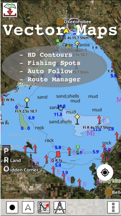
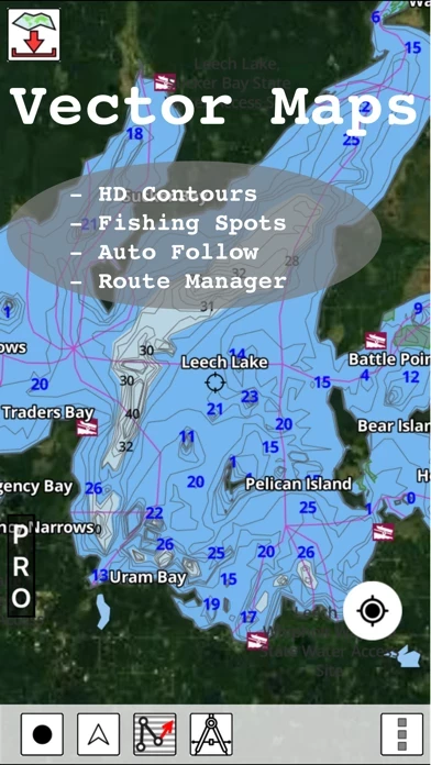
- Beautiful and detailed hardware/GPU accelerated vector charts

- Long press to query the details of marine objects

- Customizable depth and distance units

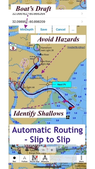
- Customizable shallow depth

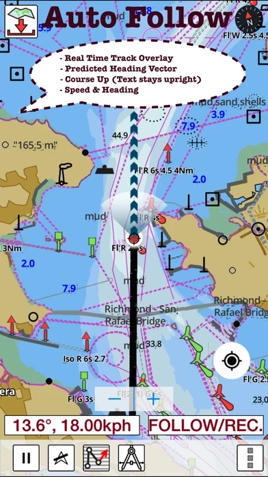
- Record tracks, autofollow with real-time track overlay and predicted path vector

- Voice prompts for marine navigation

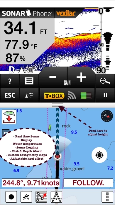
- 1ft/3ft depth contour maps for anglers for selected lake maps

- Supports GPX/KML for boating route editing/import

- Tide and currents prediction

- Seamless chart quilting of marine charts

- Enter or import waypoints

- Unlimited updates for 1 year

- Route management/trip planning

- Slip to slip auto routing

- GPS features including auto follow, real-time track overlay, predicted path vector, course up, speed and heading, and route assistance with voice prompts

- Tide and currents information for US, Canada, UK, Germany, and New Zealand

- Instrumentation including marine AIS, wind direction and speed, marine sonar depth, water temperature, and auto pilot

- Sharing options including sharing tracks/routes/markers on Facebook and Twitter and exporting tracks/routes/markers as GPX files.


Overall User Satisfaction Rating


Negative experience
67.6%

Neutral
38.1%

Positive experience
32.4%

~ from Justuseapp.com NLP analysis of 10,633 combined software reviews.

Key Benefits of i Boating

- Has been used for professional work on yachts for nearly three years without failure

- Offers an in-app purchase cruising guide feature that would enable the user to access critical information about facilities

- Works very well with phones GPS even when outside of cellular coverage

- Includes excellent ENC charts for both offshore and inland navigation

- Pulls all the data from boats NMEA network onto the app


27 i Boating Reviews

4.5 out of 5

By


Professional Level Navigation App

I have been using iBoating for nearly three years now for professional work on yachts and it has yet to fail me.

As with all navigation, I strongly advise users have two different and independent devices running this same app. I, for example, use an iPad Air 2 and an iPhone 7, and for positioning information I use a Garmin GLO and a Bad Elf 2200 GPS signal receiver. The Garmin GLO has temporarily shut down in the past, so it is essential to have the other device running especially when operating in hazardous areas like busy channels, near shoals or barely submerged hazards such as wrecks or isolated rocks.

The main improvement I would recommend to Bist LLC at this time would be to offer an in-app purchase cruising guide feature that would enable the user to access critical information about facilities (such as good phone numbers, radio channels etc) by virtue of simply touching the facility name on the current ECS. In the event of emergencies, be they weather or mechanical etc, it would be extremely useful to be able to immediately find the phone number or radio contact information for potential landing sites like marinas.


By


I like the app but the update feels like extortion

I really do like iBoating and would have rated it higher if it wasn’t asking me to pay ANOTHER $20 for the update.

I bought iBoating last year for $22 including tax. It’s the most I’ve ever paid for an app. It kind of goes against the grain for me because so many apps I’ve had in the past and relied on have either been bought by another developer or have ceased to exist. So to come back a year later and require I purchase it again just to keep using it is a hard pill to swallow!

I can understand the cost of the map update but to stop the functions of my already purchased map to me is truly unfair. Sure I can navigate using existing routes I created but not allowing me to edit or create new routes using my existing map that I already paid for is not right. Seems like extortion to me. For this reason I don’t want to pay for an update.


By


Marine and lake GPS

I’ve used this marine charting program a few times on both the coast as well as inland lakes. It’s one of the few apps on my phone that includes excellent ENC charts for both offshore and inland navigation. Works very well with phones GPS even when outside of cellular coverage. Clearly shows where my boat is, how it got there and where it’s headed. I used to have iBoating as a backup to our onboard plotter. But I keep coming back to it since maps are more detailed and I am able to pull all the data from our boats NMEA network onto iBoating . Will post more updates as I investigate it’s more advanced toolset.
Update: after 100s of miles and an year I find iBoating pretty reliable and useful. It keeps getting regular updates. Tide and currents plus wind overlay have been very useful. One thing I would recommend adding is support for auto routing.


By


Boat Safety Officer, Mohave County Sheriffs Office

All of us here have tried several different applications for the purpose of navigating our lake and river, but especially for night operations as with the surrounding mountains on certain nights no Horizon is available and so you have to operate by braille at times as it is just so dark.
I have been experimenting with your app now for about three weeks and I must say that it is the most user-friendly most accurate and provides the most abundant resources for this purpose.
We are based on an Lake Havasu City an Arizona on the Colorado river and I think we have just under 50 miles of shoreline in our lake. The detail we find with your maps and depth information is remarkably accurate.
Thank you very much for the zoning such a great asset


By


Lake depth maps

Very user friendly app to download lake depth maps and coastal charts. GPS features including recording and moving map works very well and is very reliable. The support is very helpful and answered all the questions I had. I had asked them about a specific lake that was missing. To my pleasant surprise they contacted me today to let me know that they had added depth contours for it and it was a available for download.

Update1: I’ve used it quite often in sf a yas well as Sac delta. For navigating the Sac delta I wasn’t able to identify the deep channel. The support was very helpful and suggested me to change the shallow and safety depths. Once I did that I was able to identify the deep channel. I plan to use it in Shasta next week. I am glad they cover it. Will update the review with more details next week.


By


Recommended!!

I recommend iBoating to anyone looking for a primary or a secondary gps chart plotter.

Purchased the US version a few years back for kayak and shoreline fishing in the Tampa Bay Area. Although I have been reduced to the free version after being unable to restore my iCloud when changing phones, I finally bought myself a small boat and got to use this app to find a wreck today. The gps was spot on with this parted iPhone5. No bottom finder test but we were catching fish as soon as we dropped a bait on the sunken sailboat. I will be soon to make the commitment to get the most out of what this app has to offer. If they sent me a shirt and a sticker I would represent this company just like I do for other respectable companies.

The team at this app have done a great job on this application.


By


Works and Support team is very helpful

I’ve been using iBoating for quite some time and it’s always been reliable and very functional for my navigation needs. Over they years I’ve built and honed a number of routes around hazards and navigational issues that makes this a critical part of my boating safety. Recently, after an iOS hardware upgrade, a new phone, I was having difficulty restoring my routes which were saved on an iPad back to my phone. On a Saturday I sent a email to the support team and they answered back almost immediately, worked with me on my issue and within 15 minutes my routes were thankfully restored to my phone. Now that is going above and beyond to make a customer happy. Thanks.


By


Needs fixing!

So after being intrigued by the simple but elegant app logo I was greeted by a prompt to download maps as there were no maps installed and after tapping yes I thought everything was fine. I spent about 1 minute trying to figure out the apps features when iBoating just crashed and I was sent back to the home screen. As I thought it was because iBoating couldn't handle me navigating through the map too quickly I tapped on the icon again and was greeted by the same prompt (would you like to download any maps) and after tapping yes I tried to figure out more about iBoating for the second time. But again iBoating cashed about 1.30 minutes after the prompt . This happened repeatedly till I lost all hoe in using iBoating . Definitely a thing which the developers ave to fix. By the way I am on an IPad 4.


By


No Maps Available

I'm not sure what all the 5 star ratings are about. I kept clicking on regions to download freshwater lake maps (Large lakes with ports like Lake Coeur D'ALene, Pend O'rielle and Dworshak Reservoir in Idaho). Nothing comes up...just errors stating there is no data. Don't waste your time on iBoating.

UPDATED: The developer contacted me about how to download the maps, which was helpful. I was clicking too long and holding down the tile too long. So I did a short click in the region where I wanted a map to test out iBoating . (Lake Coeur D'Alene area). It highlighted that area, but downloaded a map (my one free download of course) for the Columbia River in Washington instead. Nothing in Idaho shows up except for Priest Lake which is not where I go fishing. Something is off on your Idaho mapping system. Not going to try this again...if I can't see the detail of the lake I want before I purchase, I'm not going to buy it.


By


Routing has potential

I was a little hesitant to try out automatic routing when their tech support told me about it. Now that I have tried it I have to admit it’s very useful. It’s able to identify the channel and route around islands and rocks. I was impressed that when I changed the draft, it was able to identify the channel like I would have done it manually. The route changes every time I change the draft. So that seem to be working.
Not sure that I would rely entirely on fully automatic. But it’s definitely a good step in the right direction.


By


Maps does not download: error message

I just got iBoating and when you tap the map to download- it gives an error message. I would eventually like to purchase if it works- but I will not be willing to risk paying for $20 bucks and it doesn’t work.

Update: I contacted support on a weekend and they responded back within hours and gave me instruction on how to download the map. And it works!!!! Now I’m a satisfied customer. Will be trying iBoating out on the boat this weekend. So far, as I am reviewing it, it looks detailed and very useful. If it is what it set out to be, I will be purchasing iBoating.


By


Support is non-existent

I purchased the USA maps last year and everything worked fine until I got a new phone. I’ve tried numerous times to activate iBoating on my new phone but it still shows my license tied to the old phone and won’t let me do anything unless I buy a new license. I have emailed the support email address numerous times to have my license transferred to my new phone but have never received a response. There is no phone number to contact anyone and the website is seriously outdated so it seems like the license process is automated and they are no longer supporting their app. Stay clear unless you want to pay for a new license and start over new every time you get a new device.


By


Good app but some improvements possible

I definitely like iBoating overall, cool to be able to see depth changes in the lake and pick spots to fish based on that.

Only real cons are (1) the navigation is not super accurate when tracking you, and several times when I updated it it jumped all over the map. (2) similarly would be nice to not have to update to see where I am, but instead to have real time updates as I move on the lake. (3) finally, my map does not show any POIs and despite app saying it also recommends fishing spots, it does not do so, at least not for this lake.

Overall a good app though and well worth the price.


By


Effective, cheap, easy!

We boat in multiple locations from Delaware watershed and Pennsylvania lakes, to Hampton's, to Atlantic City, Virginia Beach, occasionally in Northern California...

Usable simple maps, obtained as downloads after app purchase....

I have been very pleased by the ease of use, quality of tracking, and ability to download decent quality maps to remote areas as we reach them.

My family agrees that excellent bang-for-buck. Having compared to standard nautical charts, is perfectly adequate for routine navigation.

Wish List:
- that maps could be automatically downloaded based on boater's location
- automatic centering of your location... can require re-clicking in screen to re-center your location
- advanced information on docking locations and communication channels imbedded in maps...

But really happy I can grab my iPhone in a waterproof case and navigate almost anywhere for a couple of bucks!


By


In depth review of this app

Gives the user friendly great access to nautical information as far as depth , & marked fishing areas where differing species have been caught, but it could be better served with information as far as connecting la land based ma, in order to provide information to those who are also fishing from shore, ... the lack, of put in/take out areas, that could/would also be relevant to last cal eateries, and bait shops/gear-based shops, & amenities such as electrical , fuel, & ice to be obtained is also crucial not only to the fisherman using iBoating, but also to the local economies that are there to provide these unique services, ...


By


Confusion

No instructions to fully utilize app. Selected one (1) free area to evaluate product but app keeps returning me to my present location, therefore, I could not use route planning. Do not even know how to buy the area I want.
The site replied to my concerns promptly but their reply did not address my needs.
The chart details are excellent but can be cluttered. Lastly, maneuvering around led me to get lost. But, perhaps this was due to the fact that the search method did not locate a prominent port for me. I believe it is an outstanding app but needs some refinement.


By


VERY GOOD

I only give 5 stars when something is amazingly good. That said, iBoating is VERY GOOD. Basically, nothing comes close for the money considering subscription prices to data. For my needs (21’ sailboat on lakes -including the Great Lakes) this pretty much covers it. The coverage of smaller Midwestern lakes is excellent.

Customer service is also VERY GOOD. I had a minor issue and it was well taken care of.

Look forward to a lot of boating with iBoating. May update after I have more experience with it.


By


It wouldn’t hurt you to have at least a decent lite version

Unless someone is to buy you extras, iBoating might as well not exist. You don’t have to waste memory and storage on your phone by downloading an app. You can just Google your home lake or any other lake of choice and the words NAUTICAL MAP to get the same results as this. You could at least make your product have the GPS work on the lite version so you could call it a functioning app but I guess that money over humans play a big roll in some Jews world…..Some people show no appreciation. Well your welcome for World War II.


By


Accuracy Paid Dividends

My trip from Kaneohe Bay to Molokai brought me into a new harbor (to me) in the dark at 2100. Using iBoating to guide us to the Lono Harbor we found it incredibly accurate as we shined our spotlight on the lineup markers and just close enough to the large rocks to feel some real joy at dropping anchor safety. I immediately asked my navigator what app he was using and purchased it the next morning!! Saved my boat and gave me a very good night’s sleep! Highly recommended!


By


Very disappointed

I thought this seemed like perfect app for me since I take my boat all over to many lakes in my home state and other states, some far away. So I paid for the upgrade to get all US LAKES. And that was last week. Then this weekend we decided to go boating on the chain of lakes. So imagine my surprise when iBoating doesn’t even know the lakes exist. I thought ok I’m sure it will work once we get to a larger lake on the chain. Nope. Shows the boat on dry land. So I’m not happy. Wasted $20 for maps that don’t even know that some of the lakes I want to go on exist. I know that there are GPS units that have inland lake maps for pretty much every boatable lake but iBoating with US lakes is not it. Sorry for rating. I wanted this to be GREAT and thought it would be.


By


Very functional but not intuitive

Once I figured it out, it was the best $20 I ever spent. I still haven't figured out how (or if it's even possible) to chart a course starting at an address on land. What I did was plot a course from one distinct landmark to another and it worked well even when I lost cell service.


By


Perfect for what I needed

Finally got to use this for what I intended it for. Just returned from 4 days fishing in the west coast of Vancouver Island. The loaded charts in my Garmin fishfinder/GPS don’t cover the area. Rather than spend the bucks on the chart package for the GPS that I’ll only use once a year I opted for iBoating. It worked perfectly and had all the functionality I needed. I used it right off my iPhone and it kept me dialed in and on course. Based on visual surroundings, paper charts, and depth sounder, it seemed to be very accurate.


By


So far sooo good!

Downloaded iBoating onto my iPad Pro along with my one free sample chart. It worked great. I’m using it for navigation on my sailboat.

I’ve now (paid for) downloaded several charts all of which have worked well. I did run into a problem with a GPS error message (wouldn’t fix my position) while pre-plotting a route. I sent a message to the developer about it and had a response the same day. Turned out to be a system setting and the problem was rectified in short order.


By


Great App with lots of features!

By far one of the top marine navigation apps to have. The design layout is very easy to follow. The vector charts have outstanding detail and are very easy to use. Chart folios are very reasonably priced and the grid based interface makes it very easy to download charts and verify what area exists on the device. Make sure to tap on the arrow icon at the bottom. It turns on the moving map functionality.

All in all it's a great app which I would definitely use again! 5/5


By


You couldnt ask for any better

iBoating is really good. The information on bodies of water is amazing. The people are even better. If you have a problem with iBoating , contact them and they almost literally fix the issue as you are telling them about your problem. I was abit leery about the purchase price at first. After having it for a couple days.... i would have payed double what they charged had i known it would be like this beforehand.


Brian Smith   1 year ago


Lake Nipigon??? Doesn’t exist.

Rod   1 year ago


Apparentley in a very toxic person because i had a lot of issues using this app..For one it wont allow me to download it on the two android devices i own..Second..when i do get on to work it doesnt save any of my waypoints..so when i close the map i lose everything i had and start over..i asked for a refund but did not get one..there are NO tutorials or videos on how to use this..just there customer service which i do not have a complaint on..the service is very quick..but i still didnt get anything resolved so i have uninstalled the app and will lose $26.and move on...but to be called a toxic person because nothing was working is very wrong..i will be filing a complaint with the app developer..look for another app.

Nanquette   2 years ago


Hello I-boating apps is new for me. It Is on my mini ipad 2 The map relating to the french Atlantic coast is downloaded.. But the problem is that most of the time i can't see my location on the Map. Could you help me? Alexis

Masón   2 years ago


Hi, I can’t restore my purchase on iPhone. Can you help me?

Michael Smith   2 years ago


Gps error mylocation failed. How do I fix this?

Lester Hitchcock   3 years ago


Exporting tracks from my iphone to ipad. I receive the email on my ipad with the attachment. When the attachment is clicked nothing happens. The route does not import to my ipad. Any suggestions?

William Max   3 years ago


Hello , Downloaded the app plus a map. All is good except my position on map is not accurate, its approx. 1 km off !


Is i Boating Safe?


Yes. i-Boating: Marine Charts & Gps is quiet safe to use but use with caution. This is based on our NLP (Natural language processing) analysis of over 10,633 User Reviews sourced from the Appstore and the appstore cumulative rating of 4.5/5 . Justuseapp Safety Score for i Boating Is 32.4/100.


Is i Boating Legit?


Yes. i-Boating: Marine Charts & Gps is legit, but not 100% legit to us. This conclusion was arrived at by running over 10,633 i-Boating: Marine Charts & Gps User Reviews through our NLP machine learning process to determine if users believe the app is legitimate or not. Based on this, Justuseapp Legitimacy Score for i Boating Is 70.5/100..


Is i-Boating: Marine Charts & Gps not working?


i-Boating: Marine Charts & Gps works most of the time. If it is not working for you, we recommend you excersise some patience and retry later or Contact Support.


Pricing Plans

**Pricing data is based on average subscription prices reported by Justuseapp.com users..

Duration Amount (USD)
Billed Once $21.99


How was your experience with i-Boating: Marine Charts & Gps? Post a Review

Leave a comment:


Alternatives