How to Cancel i-Boating
Published by Bist LLC on 2023-12-04We have made it super easy to cancel i-Boating: Marine Charts & Gps subscription
at the root to avoid any and all mediums "Bist LLC" (the developer) uses to bill you.
Complete Guide to Canceling i-Boating: Marine Charts & Gps
A few things to note and do before cancelling:
- The developer of i-Boating is Bist LLC and all inquiries must go to them.
- Cancelling a subscription during a free trial may result in losing a free trial account.
- You must always cancel a subscription at least 24 hours before the trial period ends.
How easy is it to cancel or delete i-Boating?
It is Very Easy to Cancel a i-Boating subscription. (**Crowdsourced from i-Boating and Justuseapp users)
If you haven't rated i-Boating cancellation policy yet, Rate it here →.
Potential Savings
**Pricing data is based on average subscription prices reported by Justuseapp.com users..
| Duration | Amount (USD) |
|---|---|
| If Billed Once | $21.99 |
How to Cancel i-Boating: Marine Charts & Gps Subscription on iPhone or iPad:
- Open Settings » ~Your name~ » and click "Subscriptions".
- Click the i-Boating (subscription) you want to review.
- Click Cancel.
How to Cancel i-Boating: Marine Charts & Gps Subscription on Android Device:
- Open your Google Play Store app.
- Click on Menu » "Subscriptions".
- Tap on i-Boating: Marine Charts & Gps (subscription you wish to cancel)
- Click "Cancel Subscription".
How do I remove my Card from i-Boating?
Removing card details from i-Boating if you subscribed directly is very tricky. Very few websites allow you to remove your card details. So you will have to make do with some few tricks before and after subscribing on websites in the future.
Before Signing up or Subscribing:
- Create an account on Justuseapp. signup here →
- Create upto 4 Virtual Debit Cards - this will act as a VPN for you bank account and prevent apps like i-Boating from billing you to eternity.
- Fund your Justuseapp Cards using your real card.
- Signup on i-Boating: Marine Charts & Gps or any other website using your Justuseapp card.
- Cancel the i-Boating subscription directly from your Justuseapp dashboard.
- To learn more how this all works, Visit here →.
How to Cancel i-Boating: Marine Charts & Gps Subscription on a Mac computer:
- Goto your Mac AppStore, Click ~Your name~ (bottom sidebar).
- Click "View Information" and sign in if asked to.
- Scroll down on the next page shown to you until you see the "Subscriptions" tab then click on "Manage".
- Click "Edit" beside the i-Boating: Marine Charts & Gps app and then click on "Cancel Subscription".
What to do if you Subscribed directly on i-Boating's Website:
- Reach out to Bist LLC here »»
- Visit i-Boating website: Click to visit .
- Login to your account.
- In the menu section, look for any of the following: "Billing", "Subscription", "Payment", "Manage account", "Settings".
- Click the link, then follow the prompts to cancel your subscription.
How to Cancel i-Boating: Marine Charts & Gps Subscription on Paypal:
To cancel your i-Boating subscription on PayPal, do the following:
- Login to www.paypal.com .
- Click "Settings" » "Payments".
- Next, click on "Manage Automatic Payments" in the Automatic Payments dashboard.
- You'll see a list of merchants you've subscribed to. Click on "i-Boating: Marine Charts & Gps" or "Bist LLC" to cancel.
How to delete i-Boating account:
- Reach out directly to i-Boating via Justuseapp. Get all Contact details →
- Send an email to [email protected] Click to email requesting that they delete your account.
Delete i-Boating: Marine Charts & Gps from iPhone:
- On your homescreen, Tap and hold i-Boating: Marine Charts & Gps until it starts shaking.
- Once it starts to shake, you'll see an X Mark at the top of the app icon.
- Click on that X to delete the i-Boating: Marine Charts & Gps app.
Delete i-Boating: Marine Charts & Gps from Android:
- Open your GooglePlay app and goto the menu.
- Click "My Apps and Games" » then "Installed".
- Choose i-Boating: Marine Charts & Gps, » then click "Uninstall".
Have a Problem with i-Boating: Marine Charts & Gps? Report Issue
Leave a comment:
Reviews & Common Issues: 2 Comments
By Rob Durbin
2 years agoHow do I unregister the map license from old device to a new device. These are on Android OS. Thanks
By Hans Brüsch
2 years agoI am the the Happy user of i-boarding. I have bought maps of Denmark and Sweden. But my tablet i running out of memory. How can i delete parts of maps to release memory Space. Kind regards Hans Brüsch Denmark
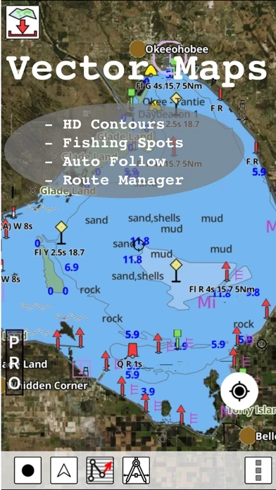
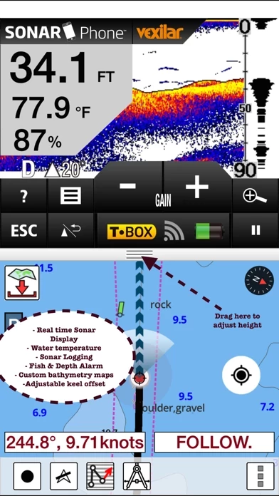
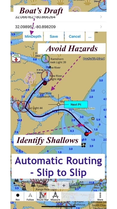
What is i-Boating: Marine Charts & Gps?
This App offers access to Marine Charts for USA,Canada,UK/Ireland,Germany,Netherlands/Holland & Europe Rivers (Danube,Drava,Rhein etc). Coverage includes NOAA marine vector charts,freshwater lake maps,USACE inland river maps (HD/1ft/3ft bathymetry included where available),charts derived from UKHO & CHS data. First marine GPS app to have route assistance with Voice Prompts for marine navigation. You can create new boating routes or import existing GPX/KML routes. It supports Nautical Charts course up orientation. Includes Tide & Currents prediction. ►FEATURES √ Beautiful & detailed Hardware/GPU accelerated vector charts (text stays upright on rotation) √ Long press to query the details of Marine object (Buoy,Lights,Obstruction etc). √ Customizable depth(Ft/Fathom/Meter) & distance units(km/mi/NM) √ Customizable Shallow Depth. √ Record tracks,Autofollow with real-time track overlay & predicted path vector. √ Voice Prompts for marine navigation (requires GPS ) √ 1ft / 3ft depth contour maps for anglers for selected lake maps. √ Supports GPX/KML for boating route editing/import. √ Tide & Currents prediction. √ Seamless chart quilting of marine charts √ Enter or import Waypoints. ► MAPS It includes unlimited updates for 1 year. √USA: The maps include coverage of all NOAA marine vector charts (ENC),USACE inland river maps,freshwater lake maps for more than 7K lakes. The charts include HD/1ft/3ft bathymetry where available.Incl. NOAA raster where ENC not available. √Canada:Inc...