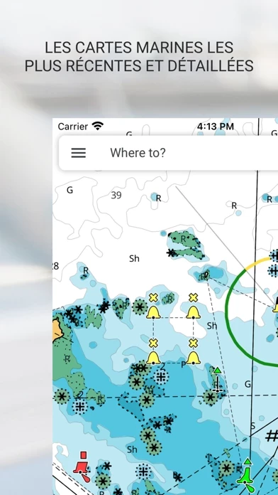
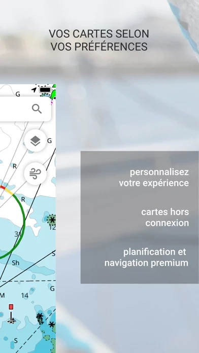
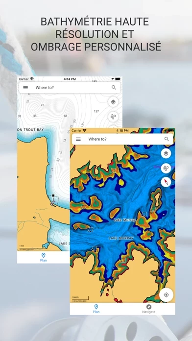
C-MAP: Boating Reviews

C-MAP: Boating Reviews

Published by on 2023-12-18

About: The C-MAP® App is your perfect companion on Mobile, Tablet or PC, planning at
home or navigating on the water. With the best, latest C-MAP charts – all in a
free download, with online viewer.


About C MAP


What is C MAP? The C-MAP® App is a navigation and planning tool that provides access to the latest C-MAP charts, weather data, and thousands of points of interest. It offers features such as Autorouting™, personal waypoints and track recording, AIS and C-MAP traffic, marine weather forecast, and chart personalization. The app is available for free with the option to purchase a premium subscription for additional features.


Features


- Free chart viewer with the latest C-MAP charts

- Unlimited offline map downloads

- GPS and full navigation mode

- Autorouting™ to find the best route to your destination

- Personal waypoints and track recording

- Import and export GPX files to share routes, tracks, or waypoints with friends

- Thousands of pre-loaded points of interest

- AIS and C-MAP traffic for increased situational awareness

- Marine weather forecast and weather along the route

- Weather overlay and chart personalization

- High-resolution bathymetry and custom depth shading

- Measure distance tool and shaded relief

- Continual updates with new features and functionalities

- Free 14-day subscription to experience C-MAP App Premium

- In-app purchases to add-on geographies (e.g. Denmark)

- Subscription automatically renews unless auto-renew is turned off at least 24-hours before the end of the current period

- Links to privacy policy and terms of use.


Overall User Satisfaction Rating


Neutral
68.3%

Positive experience
53.9%

Negative experience
46.1%

~ from Justuseapp.com NLP analysis of 1,042 combined software reviews.

Key Benefits of C MAP

- Uncluttered and super snappy maps

- Intuitive options for distance/time estimating, mapping out routes, basic weather/wave/tide data, GPS coordinates, and points of interest

- Top-notch cartography

- Frequent updates

- Responsive dev team

- Tracks and routes sync with B&G MFD

- Solid auto-routing


22 C MAP Reviews

4.4 out of 5

By


Beautiful. Fast. Intuitive. Free!

I spent considerable time this past week trying out C-MAP and other marine navigation apps like iNavX, Navionics, Wavve, etc., in an effort to find the best one to run on my iPad while sailing. C-MAP was the hands-down winner so I felt compelled to write a review and let people know how great CMAP is.

First of all C-MAP stands in stark contrast to competing marine navigation maps because it’s uncluttered and the maps are super snappy and run butter-smooth on my iPad Air. You get intuitive options for distance/time estimating, mapping out routes, basic weather/wave/tide data, your GPS coordinates, even points of interest in the area... and it’s completely FREE! If you choose to upgrade (for just $19/year) you can even see more detailed weather forecasts and AIS traffic on-screen.

As a tech CMO and recreational sailor I have to tell you, CMAP has every single thing I was looking for and nothing that I wasn’t - some serious thought went into C-MAP, from its design and feature set to its user experience. The only other marine app I use (and don’t really need) now is PredictWind, just to get really granular on wind speed and direction. I happily deleted all of the other marine apps on the iPad. If you’re searching for a boating/sailing navigation app like I was, give this one a try. There’s really no need to look elsewhere.


By


Best looking charts available

Embark has quickly become my favorite charts app. The cartography is top-notch and takes full advantage of a high resolution display. Updates are frequent, and the dev team is amazingly responsive. There are still some features I’d love to see (tidal currents, make it easier to find tide stations other than the closest and predictions farther out than a few days, track export), but they are continuously improving and I keep looking forward to seeing update notifications.

I just hooked my B&G MFD up to my account, and I’m loving the way that tracks and routes sync. That feature plus the solid auto-routing make planning a joy- no more standing at the helm fighting the smaller screen and less responsive touchscreen! Instead I can do my planning sitting in an easy chair at home while anticipating the trip!

Hats off to the devs for an app that is truly a joy to use!


By


Great when it woks

I’ve been experimenting with C-MAP while doing some offshore cruising on my IPad. I love the layout and functionality of CMAP ; the charts seem accurate compared to Explorer Charts, and the whole design is very natural and easy to use. However, twice now my offline charts have disappeared, and even with WiFi I can not get a chart to load, leaving me with a blank chart. I’ve reached out C-MAP a couple of times with no response; even though I’m a premium subscriber. Deleting CMAP and reinstalling and then downloading offline charts again seems to get things working again; albeit temporarily. It may be an issue on my end, but I don’t know as customer support seems to be nonexistent. Just don’t depend on this app as your primary navigation tool until you are sure that it functions properly, long term, on your device. I will update if C-MAP responds and helps to resolve my issues.


By


Tested 3 CMap came out on top BUT

I wanted a planning APP that I could set up next to my B&G chart plotter. The idea was trip planning and back up if I had cell connection with my router. This one works.

However, unless I can’t find out how in the instructions which could use depth, I can only add a starting point and end point on a route. this app plots you on the fastest route without regards to fixed bridges. This is problematic on the Puget Sound with a mast of 65’. I haven’t figured out how to move the route (not in documentation) This is why I knocked off a star.

My fix is to create multiple routes. Not the best way but it works fine for planning. Still better than the days of using the divider, parallel, and pencil.


By


Very Easy to use great job !!!!

I just bought my first boat and started trying to use the same tool on GO7, for weeks I tried figure out how to plan trips and watched hundreds of videos and finally I gave up and down loaded CMAP , within a hour I had all my places and routes saved now I am about to buy a iPad Pro to use for navigation tool. I really cant understand how they can make CMAP so user friendly and almost impossible for a new user to figure out same concept on the GO7 plotter also customer support would be the topping on the cake make it available and hands down every customer would be happy at least I know I would be... Great Job I love CMAP !!!!


By


This app was a godsend

My family and I were at a fish house down near port Mansfield on the inner coastal. The GPS on our boat malfunctioned when we were out there. This fog rolled into the area after dark and stayed. I frantically searched CMAP Store to find a boat navigating app because our guide had no way to navigate us back— you could not see the markers. I downloaded this from the middle of the ocean at 12am in my iPhone and used it to guide me back all the way to south padre island with 50 feet of visibility. It worked great and kept us right in the middle of the channel. My children were with a babysitter back in South Padre. There is no way I would have made it back without CMAP. I would give it 10 stars if I could . 👍🏼👍🏼👍🏼👍🏼👌🏼👌🏼


By


Longing for Garmin…..

I’ve used Garmin and Raymarine chart plotters for years, supported by Garmin’s Active Captain and/or Navionics software. This is my first time owning and using C-Map, which I’ve been working with for a couple of weeks now. First,for the life of me, I can’t get the Simrad GO9 chart plotter (recent acquisition) to sync with my iPhone (Simrad says it’s a C-Map issue and C-Map won’t return multiple emails). Beyond the sync functionality, the C-Map does not have the bottom detail, scope of relief shading and markers/obstructions/navigation detail that Active Capitan by Garmin has and/or QuickDraw support you find in Navionics, as well. All things being equal, I’d go back to Garmin, but for now I’ll just keep hoping someone from C-Map will help me use their product on the Simrad. If the product starts to work and the experience improves I’ll happily update my review!


By


New to nautical navigation

While I’ve planned road trips and extended bicycle trips, I’ve never done any nautical route planning. I find C-Maps really easy to use to chart routes. I’ve only been using it for about a week and I haven’t used it to navigate yet. If the navigation works as well as the planning, it’s going to be extremely useful. I’m only giving it four stars because I wish the names of the smaller islands in my area were named on the maps when viewing.


By


Why are the maps not up to date and depth contours are way off too!!!!

Plz tell me why the maps do t show creeks and lagoons for my country. Sometimes I record a track and it shows me driving through land and sometimes it doesn’t even record my track until I stop and start to record track again. I need some feedback fast cause it makes no sense to buy CMAP if it’s not giving me accurate readings. U need to update your maps because that is Mis-information and you can cause accidents if you try to follow your maps it’s just ridiculous to have a gps and the naps are not accurate


By


Crashed in the Erie Canal!!

CMAP is NOT accurate!! It is NOT update to date on markers or new channels/waterways. Showed us going over land when we were in a well marked channel. Didn’t show LOCKS on the Erie Canal which is a huge deal when the canal is filled with rocks and the locks are what get you safe through the canal from Lake Ontario to Hudson River. Ironically where we hit rocks and destroyed our boat is where every local knows NEVER to go but CMAP didn’t show the lock to the right and we went left and crashed! Should have known something was wrong when CMAP didn’t show a well known water way by the locals and instead showed us crossing land. Not showing locks in that area or any area that has locks is completely unsafe. Final word of advice .... no boater or local we met had ever heard of CMAP! Make sure to keep Google Maps and use Garmins backed apps; not this one!


By


Awful, awful log in experience

So I have two B&G Zeus onboard. I try to log into Embark and the Zeus says there has been a problem signing to your account.

So I log into my iPad Pro. No problem. I log out. I try to log in. It says too many attempts. Wait 10 minutes!

I log in via magic link on my MacBook Air. I change my pass. I log out. I try with my new pass, it says wait 10 minutes, too many attempts!

I get the security idea of the 10 minute hold and I know you were unsuccessfully trying to be secure but if you already let me log in vía magic link and reset the pass then the additional 10 minute hold is not too smart.

So here I am, logged out on iPad, logged out on iPhone, and logged out on 2 Zeus devices on my boat.

Congratulations, Navico.

**** A few days later, Navico contacted me with a workaround. It still involves waiting 10 minutes. I am now logged in. Raising from 1 star to 3 star until Navico gets around fixing the 10 minute timeout that exists even after changing password or logging in via MagicLink.


By


Paid for Canada Pro.

Why are Canada charts in feet? No compass rose, I guess when you can choose between magnetic or true north, you don’t need a compass rose or heading. Hope I learn what I might be doing wrong with iPad tablet

Well my iPhone has everything I want other than a compass rose and a magnetic north. The iPad Pro will catch up I hope Much better now that I found settings . All I had to do was turn tablet to horizontal. Most plotters are horizontal,I prefer vertical so I have more ahead view.

App is working great and am happy with it now


By


Unbelievable for the money and easy to use.

I run inspected excursion boats in the summer and have professional grade electronics on board. I wanted a simple GPS chart plotter for my 20 foot fishing boat but the prices did not justify it. A friend told me to try downloading the C-Map to my iPhone. Definitely impressed with the excellent accuracy of the charting and positioning. We have some narrow and tricky channels around my island. No problem with C-Map. I just ordered a mounting bracket for the phone to attach it to my boat. Captain BillK


By


Sloooow download speed

If you are using it in an area with high speed cell signal it might be fine. But if you need to download charts because you plan to be out of cell/WiFi coverage (like offshore Mexico) save your money or give yourself a few days to download charts. I am currently on day 2 of downloading less than a gigabyte of chart data on a high speed cable connection- apparently connected to a low speed C-Map server. I also run Navionics software and can easily download the entire pacific coast of Mexico and the US in minutes.

Currently going on 36 hrs just to download Baja Mexico on this app. Tolerating it now just to see how long it actually takes. My advice - go to Navionics.


By


“Go to” button disappeared?

Hi,
I signed up to annual subscription last season. As you have been updating CMAP all was working good.
However this season when I started to use CMAP , I noticed that the “Go To” button disappeared.
I still have an active subscription, however, when I go to account > your purchases> on the bottom it stated that I have an discontinued subscription. It will still work as long I keep subscribing to it.
What’s really confusing about this is, I have a normal annual subscription to the premium version. How is this discontinued? Is that the reason I no longer have the go to button?
Is was so easy to navigate on the C-map app before, now it is a nightmare. Please help.


By


Not reliable.

Unfortunately you need reliable signal for this to work which kind of defeats the purpose of it because when you’re out on the water you do not have signal. I’ll be getting a Garman as there really is no solution to be using these things even though they say the phone has GPS it won’t load the maps. I downloaded off-line version and when I went on the boat there was no off-line map it said update of line map I can’t recommend this to anybody to be confident expect to be confident out on the water with this.


By


Great Maps and User Interface

Have been using this app for two years now. We’ve traveled from Pensacola to Georgetown in the upper Chesapeake bay and back down to south Florida. The maps have been accurate, the auto routing feature saves time and the auto generated routes are easy to customize. Currently planning our Bahamas season and will continue to use CMAPs for the foreseeable future.


By


Easy to learn

I installed C-MAP on my iPad just a few day ago in anticipation of a delivery next week. I found it extremely easy to learn how to build the routs and go back and edit them. I’ll come back and post after we get out on the water and give it a try. Always remember to review your routes several times.


By


So far so good

1st time use yesterday in 10,000 islands, Everglades NP. I bought a paper chart JIC and was glad I did. Very little detail. App says I need to download area chart however there doesn’t seem to be a menu option to do this. I justified using it as a GPS for speed and to save my tracks which seemed to work for both. Opened CMAP this morning and my tracks are gone! Some simple features that looks promising - 2nd day in and there may not be a 3rd...


By


Terrible experience. Definitely do not recommend this product.

I paid for upgrade, downloaded charts, but no detail was provided on the downloaded charts (only a rough outline of land features, no depth lines etc.). I tried contacting C-Map support, but there is no way to get through the FAQ page (which was totally unhelpful) to a support person. There is no obvious way to get a refund, so I will have to contest the charge through Amex. Very frustrating. Also, when asked to choose a “nickname” for this comment, any negative name (such as “unhappy” “unhelpful” “dissatisfied”) is disallowed.


By


Newbie

I am new to all of CMAP stuff for boating. I love the idea of planning from anywhere. I just wish there was a way to transfer information back and forth to my Simrad Evo3 screens... or if there is, then I wish I knew how and I would give 5 stars and gladly pay since Navionics failed so miserably in this game and refuse to give them one more cent.


By


Disappointing change - thanks for fixing

Now in the email option for logging in worked for me. Thank you for fixing this.

But why require people who haven’t used CMAP in a while to go through this? With our boats hauled now many of us don’t look at nautical charts.


By


Easy to use

Once you figure out how to create a route from someplace other than where you are it’s very handy for planing a long multiple stop cruise. The program could provide better instructions, but I eventually figured it out.


By


Pretty, but low information charts, spam

A good chart should have more than just depth and buoy location but also include the local area rules (eg special anchorages). C-Map might draw these on the map, but doesn’t include any information about them. That’s pretty lame.

Even worse, if you give them your email, they’ll spam you every few days with random tidbits about how to use CMAP . (Maybe make those features intuitive instead?)

Position information solely comes from your iPhone. Doesn’t support NMEA.

It’s worth pointing out that auto-routing is for motorboats only. Doesn’t take wind (or likely tidal current) into consideration.


By


Great maps

I have used other maps and they work good but this one is spot on and you can link it to your Lowrance.


By


Very Handy

So far using the free app has kept us from running aground a couple of times. I’m becoming more interested in the Premium version


By


Easy to use

Very easy to use maritime app, i am a beginner in navigating and marine boats, loved the simplicity to use and the added weather, tides and all info available!


By


Easiest Nav Program

I especially like the touch screen for way points. Easy to add or delete Way points.


By


Excellent boat navigation App

It is already great! And they are making it even better! Finally I have smart autorouting for a boat! I just need the Simrad GPS Integration.


By


Like more than others

Best navigation app I found, very intuitive.


By


Review

10 out of 10 would recommend


Arden bradley   1 year ago


TWICE - downloaded offline maps have disappeared - premium subscription is active - had planned to use this as backup navigation on iPad for pacific crossing - you can return my money for subscription now

Roland Noyola   2 years ago


Can I use c map to find marinas, restaurants, and anchor places


Is C MAP Safe?


Yes. C-MAP: Boating is very safe to use. This is based on our NLP (Natural language processing) analysis of over 1,042 User Reviews sourced from the Appstore and the appstore cumulative rating of 4.4/5 . Justuseapp Safety Score for C MAP Is 53.9/100.


Is C MAP Legit?


Yes. C-MAP: Boating is a totally legit app. This conclusion was arrived at by running over 1,042 C-MAP: Boating User Reviews through our NLP machine learning process to determine if users believe the app is legitimate or not. Based on this, Justuseapp Legitimacy Score for C MAP Is 100/100..


Is C-MAP: Boating not working?


C-MAP: Boating works most of the time. If it is not working for you, we recommend you excersise some patience and retry later or Contact Support.


Pricing Information

**Pricing data is based on average subscription prices reported by Justuseapp.com users..

C-MAP App Premium

- Price: $14.99/month or $74.99/year

- Features:

- Unlimited offline map downloads

- GPS & full navigation mode

- Autorouting™

- Personal waypoints & track recording

- Import & export GPX files

- AIS & C-MAP Traffic

- Marine weather forecast

- Weather along the route

- Weather overlay

- Chart personalization

- High-resolution bathymetry

- Custom depth shading

- Measure distance tool

- Shaded relief


How was your experience with C-MAP: Boating? Post a Review

Leave a comment:


Alternatives