
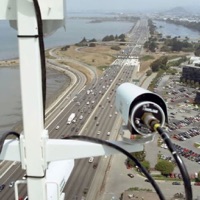
New York Road Conditions Alternatives
Last Updated on 2024-11-09 by LW Brands, LLC
Find best apps like New York Road Conditions, competitors and top software/SaaS apps in this
category. The best way to view New York traffic cameras.
MAIN FEATURES INCLUDE:
-
Create custom camera groups
- Quickly view all cameras on your route
- Live
stream applicable cameras
- Add ca...
48 Best Alternatives To New York Road Conditions
What are the best software like New York Road Conditions for 2025? Below are the most similar Navigation softwares we found.
AT&T Navigator: Maps & Traffic
Get real time traffic, maps, offline maps, voice guided directions and more with AT&T Navigator. Continued use of GPS running in the background can dramatically decrease battery life...

Waze Navigation & Live Traffic
Always know what’s happening on the road with Waze. Even if you know the way, Waze tells you instantly about traffic, construction, police, crashes, & more...
INRIX Traffic
Always know what’s happening on the road ahead, so you can arrive at your destination safely and on-time. INRIX Traffic gives you live traffic information including congestion, road conditions, construction, police activity, accidents and more, all in real-time...

ParkMobile: Park. Pay. Go.
With over 20 million users, ParkMobile is a smarter way to park. Easily pay for street, lot, or garage parking right from your mobile device...

Avenza Maps: Offline Mapping
Avenza Maps, #1 app for hiking, biking and all trails. Featuring maps from National Geographic, national parks and more!
On your next adventure, stay on track with GPS using offline mobile maps...
Sigalert.com - Live traffic reports
Save time, save money, and save yourself from the hassles of traffic jams with Sigalert.com...

Transit • Subway & Bus Times
"Gives you the best route to where you want to go" - New York Times
“You won't realize how much time you can save planning until you use this app” - LA Times
“Killer app” - WSJ
"MBTA has a favorite transit app — and it's called Transit" - Boston Globe
Transit is your real-time urban travel companion. Navigate your city’s public transit system with accurate real-time predictions, simple trip planning, step-by-step...

SpotHero: #1 Rated Parking App
Park smarter with the SpotHero iPhone app. SpotHero helps you get everywhere, easier by making it fast and convenient to find and reserve parking in major cities...
VDOT 511 Virginia Traffic
The Virginia 511 mobile application combines official information from the Virginia Department of Transportation (VDOT), driving and transit directions from Google, navigation with Waze, and other sources of information to provide a dynamic one-stop-shop for traveler information needs across Virginia.
Open the app, search for any location in the search bar, and see travel times for driving and/or transit options to that loca...

Google Maps
Navigate your world faster and easier with Google Maps. Over 220 countries and territories mapped and hundreds of millions of businesses and places on the map...

ParkWhiz - #1 Parking App
Take the hassle out of parking with the ParkWhiz app. Find parking in any major city, compare prices, plus save up to 50% when you book in advance...
Subway Gopher - New York
Door-to-door public transit and walking directions in New York, Philadelphia, and urban areas in New Jersey and Connecticut. Subway Gopher covers the entire MTA network, including LIRR and Metro North, as well as Staten Island Ferry, PATH, NJ Transit, SEPTA, CT Transit, Bee-Line, NICE bus, and many more...

Exxon Mobil Rewards+
The most secure and easy way to pay for fuel and earn rewards.
Exxon Mobil Rewards+ app allows you to stay in the comfort of your vehicle while you pay for Synergy™ fuel with your phone...

onX Hunt: GPS Hunting Maps
onX Hunt has been featured in Field and Stream, Outdoor Life and American Hunter as the best hunting app, hiking app, and GPS app for any outdoorsman or hunter. Used by millions of US hunters...
New York City Subway Map
The free New York Subway Map app has everything you need to get around NYC Subway including -
- Offline MTA New York City Subway Map
- LIVE MTA Subway Route Status
- NYC Trip Planner
- New Jersey Transit Schedules
- Late Night Subway
- NJ Transit Rail Map
- Newark Light Rail Map
- Hudson-Bergen Light Rail Map
- NJ Transit River Line Map
- Long Island Rail Road Map
- LIRR Train to Subway
And of course the MTA New York City Sub...
JFK Airport, NYC New York.. Flights, car rental, shuttle bus, taxi. Arrivals & Departures.
Airport & Airlines Guide is a smart, multi-language, easy to use flight and travel planning tool with real-time flight boards.
Flights Planner allowing you to view all worldwide flight services and connection options...
New York Fish and Wildlife App
The Official New York Fishing, Hunting & Wildlife App was created in a collaborative effort between the New York State Department of Environmental Conservation and ParksByNature Network™.
Gain access to useful information in the palm of your hand...


SmartHalo - Bike smarter.
Bike smarter with SmartHalo, a minimalist, award-winning, circular interface that pairs with your iPhone to elevate your cycling experience. This is the smart biking device you’ve been waiting for...
California Traffic Cameras
Disclaimer: This unofficial app does not represent Caltrans and is not affiliated with Caltrans. The source of the data is the publicly accessible Caltrans Commercial Wholesale Web Portal located at https://cwwp2...
Speed Cameras Radar
Discover all speed cameras, police traps, radars and traffic light cameras!
Always know what speed cameras are around you. Even if you are navigating, you can see the speed cameras along the way and receive real time notifications...

Radarbot: Speed Cameras | GPS
The only app that combines real-time alerts with the best offline radar detection alert system. With Radarbot, you will have the best radar alerts, real time traffic alerts and specific speed limit alerts for different vehicles (cars, motorbikes, trucks and commercial vehicles) in one powerful app...

We Camera 03 | Street View App
We Camera 03 is an app that anyone can use Street View easily.
Main Features:
• Current location navigation (Street view and map are synchronized)
• Point designation by hold
• Create route
• Street view and map on the same screen
• Multiple pins
• Four types of map
• Share
• Search
• Traffic
• Full screen
Supports:
• iPhone / iPad and Latest devices, Latest iOS
• Device Rotate (Portrait / Landscape)
...
Border Traffic
The BorderTraffic app helps you save time with near real-time videos of the San Ysidro (San Diego) / Tijuana and the Otay Mesa / Tijuana border crossings, 24 hours a day, 7 days a week. Simply by using this app, you can make informed border crossing decisions based on current video information, thus saving time, money, and frustration...

Eric's New York - Travel Guide
Let Eric be your personal travel guide to New York! Discover all the highlights of the city offline with tips, walking tours, metro maps and ticket discounts!
What is in the app?
An offline map of New York.
This map highlights all kinds of points in the city...

Traffie Navigation & Traffic
Traffie Navigation provide exceptional navigation experience.
Traffie tells you instantly about traffic, construction, accidents, crashes, & more...
Speed Cameras Radar Detector
You can use Speed Camera Radar to detect hazards on the road, such as speed cameras, red-light cameras, speed bumps, bad roads, etc.
The application uses a database of points filled with love by other users...
Speedometer Limit Camera
Speed Limit App displays the current speed limit and your current speed. It detects European speed limit signs using the camera while driving and enhances the results by map based limits from OpenStreetMap...
GPS Navigation & Live Traffic
Navigate to your destination faster and easier with advanced Maps and Navigation tools. Always get real-time GPS navigation, traffic alerts, local maps and explore places like a pro...

New Skins Quiz for fortnit...
This Quiz by Fishplayer allows to players to test their knowledge about outfits and skins of fortnight.
Last outfits and skins are included in this app and always updated to cover all questions of the fortnight game...
GPS Camera 55. Field Survey
Capture and stamp photos with location, date, address, notes. Add hand drawn annotations...

New York MTA Bus Time
Lightweight bus tracker for the New York City Region Transportation MTA Bus Time.
- Fast
- Easy to use
- Save your favorite stops and get the next arrivals in one touch
- Reliable
keywords: MTA, Bus Tracker, Metro, Transit, Nextbus, Bustracker, Bus Time, Bustime
Disclaimer: The data is provided by theMTA and we cannot guarantee the accuracy...

EV Charging by NewMotion
This app is exclusively for public charging with a NewMotion business card or a charge card from a NewMotion partner.
If you do not have one of these charge cards, please download the Shell Recharge App...

Houston ConnectSmart Traffic
Avoid traffic and save time and money with ConnectSmart, Houston’s first all-in-one, customized commuting and transportation app that improves your daily commute and travel within the greater Houston region.
Customized Travel Options Tailored To Fit Your Needs
Whether you’re a Houston driver looking to avoid traffic with real-time GPS navigation and road conditions, a METRO rider looking to improve your trip, or a carpoo...

GPS Tracker: Offline Maps, GPX
Create, import, export tracks with waypoints. Supports offline maps, no time limits, no ads, no in-app purchases...
Snowmobile Trails - New York
The best way to view New York OPRHP Snowmobile Trails information.
TRAIL INFORMATION
+ Name / ID
+ Class
+ Club
+ Mileage
+ High Snow / Mileage
+ State Land
+ Subsurface Description
VIEW YOUR RIDES
+ Visually recap every ride on the map
+ Color coded tracks based on elevation
TRACK YOUR STATS
+ Max Speed
+ Total Distance
+ Total Vertical
+ iOS 14 Home Screen Widget
+ Filter stats by individual Ride, Season, ...

Parkaroo
Quickly find on-street parking with the Parkaroo iPhone app. If you are frustrated weaving through city streets looking for parking or paying for an expensive garage, Parkaroo is the app for you...

New York Subway - Metro NYC
Metro NYC features a fully interactive official MTA NYC Subway map, realtime transit information and trip planner. Navigate New York city using the Subway with everything at your finger tips...

Akha
Akha is a public transport incident reporting application. It allows users to quickly and easily report any issues they encounter while traveling, such as equipment failure, delays or inappropriate behavior...

Cee Speed Camera & GPS
**Safety**
Your safety is our concern, Cee warns you of any upcoming radars, road accidents, traffic or unexpected road changes, so you can enjoy your journey.
**Efficient**
Being late is a thing of the past, Cee shows upcoming traffic that you can avoid to arrive on time for your meetings, flights, and other important events...

Friend Tracker: Locate Friends
Friend Tracker is a great tool for caring parents and friends who want to check that their loved ones are safe and secure.
Friend Tracker is a unique app with family safety features that allows you to easily get in touch and check the safety of your friends and family, anywhere in the world...
Nevada 511 Road Conditions
The best way to view 511 Nevada CCTV traffic cameras.
MAIN FEATURES INCLUDE:
- Create custom camera groups
- Quickly view all cameras on your route
- Add camera widgets to your home screen
- Live stream applicable cameras
- View NDOT & Vegas cameras
CREATE CUSTOM CCTV CAMERA GROUPS
Create custom groups of cameras based on your frequented routes and then simply scroll through the list of images...

Shechuna
Shechuna is the hub where Crown Heights connects! Discover more about what’s going on in the neighborhood. Events, Lchaims, Shuls, Mikvahs or Batei Midrash, come to Shechuna to find it all...
Mph Tracker Odometer Hud Speed
Speedometer & GPS Tracker - Take Control of Your Drive !
Speedometer & GPS Tracker is a feature-rich mobile application packed with the latest technological advancements. It measures your real-time speed, ensuring a safer driving experience in any vehicle...

Virginia Traffic Cameras
The best way to view Virginia 511 traffic cameras.
MAIN FEATURES INCLUDE:
- Create custom camera groups
- Quickly view all cameras on your route
- Live stream applicable cameras
- Add camera widgets to your home screen
CREATE CUSTOM VA 511 CAMERA GROUPS
Create custom groups of VDOT cameras based on your frequented routes and then simply scroll through the list of images...
GPS - Phone Location Tracker
GeoTrack360 is a reliable way to track your loved ones' location in real-time. Using our app, you can ensure the safety of your family and friends by knowing their exact whereabouts...


