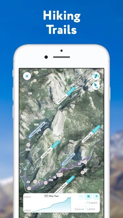
Hiking & Skiing - PeakVisor Reviews

Hiking & Skiing - PeakVisor Reviews

Published by on 2023-12-23

About: PeakVisor will make you a superhero of outdoor navigation by putting
state-of-the-art 3D maps and mountain identification magic wand in your
hand. "PeakVisor uses your iPhone's camera and augmented reality (AR)
technology to display names and elevation of nearby peaks.


About Hiking Skiing


What is Hiking Skiing? PeakVisor is an app that uses augmented reality technology to display the names and elevation of nearby peaks. It provides state-of-the-art 3D maps and mountain identification features to help users navigate the outdoors. The app allows users to identify mountains, plan hiking routes, track their outdoor adventures, and even identify mountains in photos. It is available for offline use and is useful for winter sports as well.


Features


- 3D mapping of hikes

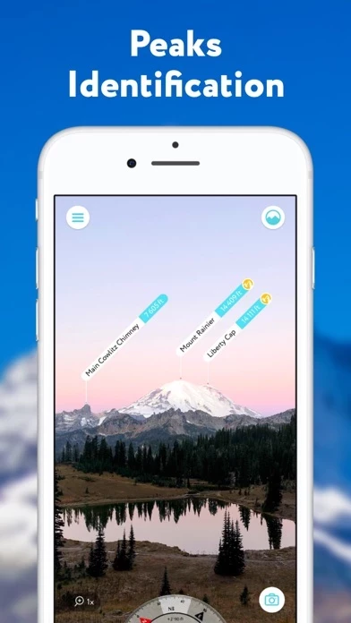
- Mountain identification from hundreds of miles away

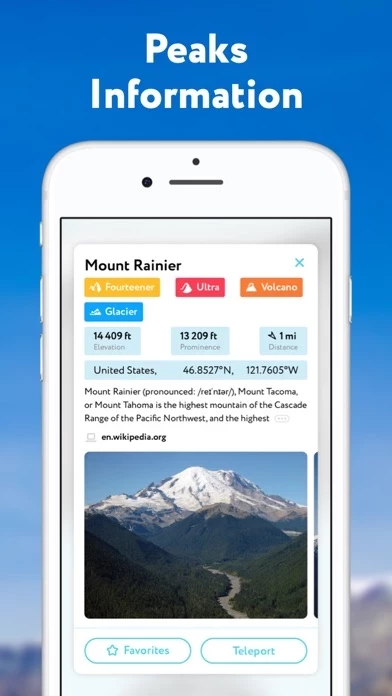
- Detailed profiles for each mountain, including altitude, topographic prominence, mountain range, national parks or reserves it may belong to, photos, and additional Wikipedia articles

- Planning of hiking routes with distance, elevation profile, and estimated time for completion

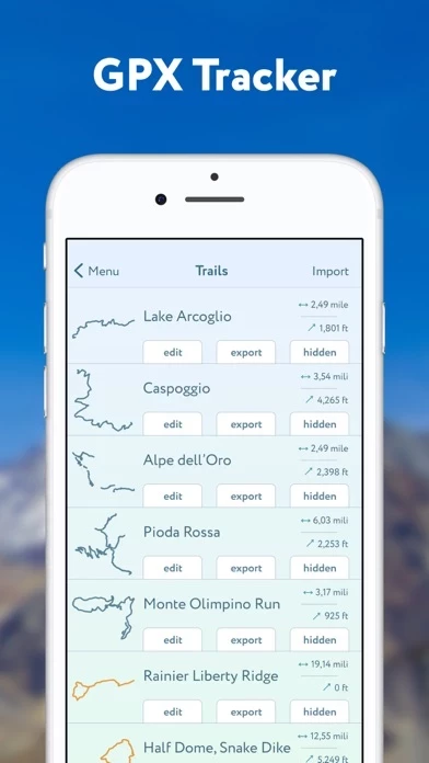
- GPS tracker to track outdoor adventures and import/export GPX files

- Offline use

- Identification of mountains in photos

- Useful for winter sports with detailed information about mountain lifts, ski runs, and popular backcountry skiing opportunities

- PeakVisor PRO premium subscription for unlimited use of the app

- Automatic renewal of subscription unless canceled at least 24 hours before the end of the current period

- Management and cancellation of subscriptions through App Store account settings

- Terms and Privacy Policy available at https://peakvisor.com/en/terms.html

- Contact at [email protected] for questions or discussions about mountains.


Overall User Satisfaction Rating


Positive experience
50.8%

Negative experience
49.2%

Neutral
14.2%

~ from Justuseapp.com NLP analysis of 10,039 combined software reviews.

Key Benefits of Hiking Skiing

- Easy to use

- Detailed images of the area

- Ability to teleport to different locations

- Ability to superimpose the horizon line and the names of peaks onto your phone screen

- Ability to download photos with labels

- Ability to upload a picture and have the app add labels

- Ability to pre-download data to save data quota

- Ability to identify peaks with point and shoot


20 Hiking Skiing Reviews

4.6 out of 5

By


Amazing tool for learning the mountains

I have been very impressed with the breadth and abilities of HikingSkiing. It has become my go-to tool for learning about the topography of mountains in California. Many times before HikingSkiing, I had wondered what mountains I could see. HikingSkiing makes incredibly easy to find out.

Before going on trips, I enjoy using the teleport feature to see the layout of the area. You can see relatively detailed images that give you a good idea of how your path will look from each position, so it’s useful for back-country treks where good trails aren’t available. The new 3D feature is very useful here as well. There are actually quite a few trails uploaded here too, so it is useful when you want to find the direction to a trail.

Both live and picture-based landscape matching work really well. I appreciate the download zone option, since there isn’t always service in the mountains. The landscapes are surprisingly accurate, and all of the features are easy to use.


By


Great

I’ve been backpacking in the mountains for about 30 years using Maps then handheld GPS and phone enabled GPS, and I just added this product to my quiver. I really like it a lot. The core functionality is that it lets you superimpose the horizon line and the names of peaks onto your phone screen when you have your camera viewfinder enabled. This works well and I have learned the names of a lot of features that I have been looking at for years without knowing what they are called. You can download these photos with the labels on them. You can also upload a picture and HikingSkiing will add labels— assuming the photo is geotagged. The final feature that I will mention is the virtual terrain mode, which allows you to “see over” ridges. All this has really added to my understanding of the mountains that I backpack in southern Idaho. Highly recommend.


By


Wonderful, but know that it uses a lot of data.

Update: The developer has explained that the data is necessarily large but that it can be pre-downloaded at home to save data quota. Since that was my only complaint I've upped my rating to 5-stars. Users on a measured plan should understand that the HikingSkiing will pull a lot of data in the field if it hasn't been previously downloaded.

It really is quite amazing at identifying peaks - point and shoot! - and I feel bad about dissing it. But in 3 or so minutes, over a less than 30 degree segment of the horizon, it just blew through my - admittedly low, 100MB - entire monthly data allowance. This won't be a barrier for most people but those light-users on a measured plan, as I am, should know upfront: expect a hefty download to do what it does.


By


Pro version required!

Upon installing the application I was notified that I would need the pro version in order to locate peaks in more than one location per day. Seemed fair enough, I likely won’t usually need to use this more than once a day but I figured I’d sign up for a year membership if I enjoyed using the free version.

I entered into HikingSkiing to try it out and learned that I needed to download data for my vicinity, 130mb.. Seems like they must be doing something pretty inefficient to require a file that large for everywhere you go (and certainly makes it impractical if you have low cell service, like for example in the mountains lol) but I allowed it just to try it. While I am waiting for the information in my vicinity to download I am prompted that I have used up my one location for the day and must pay to view more. So essentially, I spent my free location for the day downloading unnecessary data (even though I was still in the same location lol). Pretty sweet! Looking forward to checking out other options or writing my own app for this.


By


An exceptionally useful tool!!

An excellent app for learning the names of visible mountains in your vicinity. HikingSkiing is easy to use and offers an outline of the peaks you’re viewing that can be moved and aligned with the camera image of the peaks to accurately position the labels on each mountain. If you live near mountains, this is a must-have app. It’s intuitive to use and saves photos of the peaks you label for review later. The only drawback is that the free version can only be used in one area per day. If you’re moving through several locations in a day (e.g. driving for an hour or more through several sets of mountains) you need to subscribe to the Pro version of HikingSkiing .


By


I DETEST SUBSCRIPTIONS!

Please just figure out what a fair price is for HikingSkiing (high or low) and I’ll pay it. I am overwhelmed with monthly subscriptions and will not buy anymore. I would gladly pay whatever you consider a fair price to own it. It’s getting out of control. Too bad because it appears that the full version is amazing. :(

9/4/21 Any consideration given to a one time fee? If you think people would be deterred due to the price I think you would be surprised. Of course you can keep the monthly/annual purchase option, but I want a one and done price. After spending a little bit of time with the free portion of HikingSkiing I am sure it is worth whatever you would need to charge for a on time fee. Tanka for considering this request.


By


Great tool

This is really a wonderful tool. It’s still evolving so it will only get better. The user interface is not instantly intuitive — for example, the great 3D hiking/terrain maps are displayed by double tapping the compass. Who’d have thunk to try that? But already a great travel companion. I haven’t really used it in the field yet but have high hopes based on test usage so far. I’m optimistic for steady improvement.


By


Black Mtns WNC

“Just open HikingSkiing and point the camera.” Sounds easy. I’m in the highest mountain range in the Eastern USA, the Black Mtns in Western North Carolina. I’m 4.01 miles from Mount Mitchell (measured with my Garmin GPS), the HIGHEST PEAK in the Eastern United States, and after nearly a dozen tries, HikingSkiing has identified NOTHING, although it did indeed download the data it needs for this area. I can clearly see Cattail Peak, one of the southern sixers, from my property. It’s barely a mile away. When I aim the camera at Cattail Peak, HikingSkiing provides no data whatsoever, even after adjusting and readjusting numerous times, as the user is prompted onscreen to do. After trying over and over, all day long, all I’ve gotten is crude line drawings of mountains. GPS data, yes, but no peak data whatsoever. Nothing. Zilch. Nada. The instructions, which I’ve read, reread and reread, over and over, provide no help whatsoever. Only brief and cursory explanations. Sorry I wasted my money.


By


Awesome

Works great! This is a must-have for any mountain enthusiast. Albeit it does not suffice for a quad map or good gps, it does provide great information and pinpoint location of peaks.

I am told that next version is in near future with more great functions.

Hint to developer: I would like to see glaciers added. Also a function to mark peaks that I have achieved with dates and notes. This would be a great peak-baggers journal!


By


If you’re a hiker/geography nut, you’ll love this app.

I love HikingSkiing. I use it all the time on hikes. If you’ve ever wondered, “hmmm... what is that mountain over there” you’ll like HikingSkiing. I’ve downloaded all the mountain ranges that I frequent. It helps me have a better idea of which mountains I want to climb and where they are in relation to myself. Great app!


By


Works great

I used HikingSkiing when backpacking in Yosemite Np. It showed names and detail of all the peaks that appear in my real time camera and even some peaks that were behind objects. Of course I had to download offline data of Yosemite region before hand. Overall I think HikingSkiing deserves 5 stars because It helped me a lot in backcountry


By


Nice design, horrible execution

I wanted to test HikingSkiing to see if it’s better than the one I’m currently using. So I’m up in the mountains and I load it up. Takes a while to download and stitch the panorama. And then nothing shows up, at all. So I restart HikingSkiing , and wait again, and then the outlines of the mountains are in the sky, like way up in the sky, and the horizon isn’t even level. Whatever I used my other app. So a couple hours later I try to give HikingSkiing a second (third) chance, and it’s locked out! One location per day. Wow great job guys.


By


Utah traveler

I am on vacation in Southern Utah and said, “wouldn’t it be nice to know what mountains and geographic features I am looking at?” Well guess what, questions answered. Thanks to the developers for such an amazing app. Could not be happier! Even used the teleport feature to go back to park I have already been, and identified mountains that I wondered about. Great product!


By


Missing standard feature

Great app, but missing landscape support. Only portrait mode is supported in the interface. While HikingSkiing make “look” like it supports landscape mode, the interface demonstrates that HikingSkiing still thinks of itself as only in portrait mode. This is seen with the startup screen and the subscription sign up screen... along with other visual components. Functionality is impaired on the iPad Pro 12.9 (3rd gen).


By


Happy for now!

Had a 1 star rating because of the subscription change and thought I’d be losing offline access in a year. The developer made it clear, via email, that nothing changes, at all. So, for now, 5 stars. Great app, always love using it while out in the woods!


By


Free version is useless

It worked once at my home. I waited a few days to try a new location since the “one location a day” paywall came up. Can neither load in a new location or determine what location is being used as it won’t load at home any more either. It’s just a bricked app now with no functionality asking me to pay a cup of coffee every month. I don’t drink coffee. And I don’t believe in never ending subscription models without any guarantee of new services.


By


Awesome for Peakbaggers!

I’ve climbed nearly 40 mountains, just climbed my first with HikingSkiing on my phone. It added so much to the experience. I can look around and get a bearing on exactly where I am and what I’m looking at, as well as what is over the next hill that I haven’t been to yet. Just Great!


By


Would be PERFECT but...

Love everything about HikingSkiing except the way it updates. For some reason nearly every time I try to use it, it needs to update the data by downloading the vicinity. Of course this is always exactly when I’m on the trail without data or wireless available. HikingSkiing beats the competition in about every other way by leaps and bounds so I hope they fix that!


By


Amazing!

I had a problem with HikingSkiing . My issues were completely fixed in the update today. They also sent me the most helpful video. Fantastic customer and really cool app.


By


Fantastic Application!

Just love the application. We live in a mountainous area and it’s wonderful to have this tool. It also very much enhanced our experience on a recent trip to Glacier/Waterton Lakes and Grand Teton National Parks. Unbelievable how much capability we have in such small devices these days. Great job to the development team!


By


Works great

I used HikingSkiing when backpacking in Yosemite Np. It showed names and detail of all the peaks that appear in my real time camera and even some peaks that were behind objects. Of course I had to download offline data of Yosemite region before hand. Overall I think HikingSkiing deserves 5 stars because It helped me a lot in backcountry


By


Great and useful app

I love Peakvisor. I hike in the Adirondacks, and I’m never quite sure which peaks I can see from my location. Peakvisor makes it easy! The developer is very responsive; I asked a question and he replied in a few hours. A great app, and new features are added frequently.


Is Hiking Skiing Safe?


Yes. Hiking & Skiing - PeakVisor is very safe to use. This is based on our NLP (Natural language processing) analysis of over 10,039 User Reviews sourced from the Appstore and the appstore cumulative rating of 4.6/5 . Justuseapp Safety Score for Hiking Skiing Is 50.8/100.


Is Hiking Skiing Legit?


Yes. Hiking & Skiing - PeakVisor is a totally legit app. This conclusion was arrived at by running over 10,039 Hiking & Skiing - PeakVisor User Reviews through our NLP machine learning process to determine if users believe the app is legitimate or not. Based on this, Justuseapp Legitimacy Score for Hiking Skiing Is 65/100..


Is Hiking & Skiing - PeakVisor not working?


Hiking & Skiing - PeakVisor works most of the time. If it is not working for you, we recommend you excersise some patience and retry later or Contact Support.


Pricing Information

**Pricing data is based on average subscription prices reported by Justuseapp.com users..

PeakVisor PRO

- Monthly subscription: $5.99/month

- Annual subscription: $29.99/year


How was your experience with Hiking & Skiing - PeakVisor? Post a Review

Leave a comment:


Alternatives