Topo GPS - Topographic maps Software
Company Name: rdzl
About: Topo GPS is navigation on the most detailed topographic maps.
Headquarters: , , .
Topo GPS Overview
What is Topo GPS?
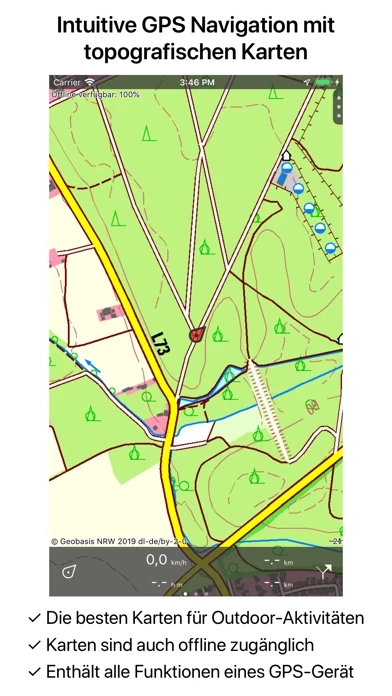
Topo GPS is an app that turns your iPhone or iPad into a complete GPS device with detailed topographic maps. It is ideal for outdoor activities such as walking, hiking, cycling, mountain biking, sailing, horse-riding, geocaching, scouting, trail running, and other outdoor activities. The app contains all the functions of a regular GPS device for less money, has a much more detailed map, and is more convenient to operate.
Features
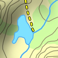
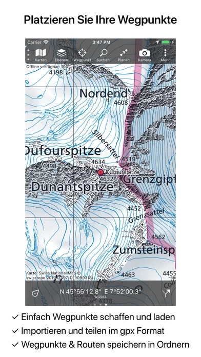
- Map: Topo GPS requires purchasing a map to use. Official topographic maps of many countries, including Great Britain (OS Explorer), New Zealand, and Australia, are available as in-app purchases. Topographic maps are very detailed maps, include height contours, and are very suited for outdoor activities. All maps of a certain region can be made offline accessible using the map download screen. Easy switching between maps.
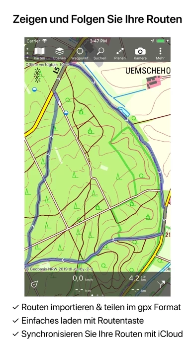
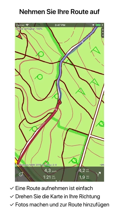
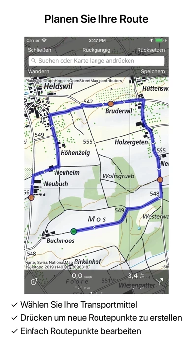
- Routes: Recording routes, with pause and restart possibility. Planning routes via route points. Generating routes. Editing routes. Synchronization with your other devices via iCloud. Searching routes with filters. Routes can be organized into folders.
- Waypoints: Easy adding by pressing long on the map. Adding waypoints through address or coordinates. Sharing waypoints. Editing waypoints.
- Layers: Layers contain information that can be added to and removed from the map. Long-distance bicycle routes. Mountain bike routes.
- Coordinates: Easy entering coordinates. Scanning coordinates. Supported coordinate systems: WGS84 decimal, WGS84 degree minutes (seconds), UTM, MGRS, and other country-specific coordinate systems. Coordinates grid layers.
- Intuitive interface: Clear menu with the most important functions. Different dashboard panels with distance, time, speed, altitude, and coordinates. Clear manual at www.topo-gps.com
- Supported file formats: gpx, kml/kmz, geojson (all also zip compressed), WFS, csv.
Note: If you are recording a route, the GPS will run in the background. Continued use of GPS running in the background can dramatically decrease battery life. Rdzl, the company behind Topo GPS, does not obtain in any way the position of the user of Topo GPS. Rdzl does also not obtain the routes recorded by the user and save the routes planned by the user, unless the route is shared with Topo GPS. The app is sold as a product, not user data. Privacy policy: https://www.topo-gps.com/privacy-policy. Terms of use: https://www.topo-gps.com/terms-of-use.
Official Screenshots
Product Details and Description of
Makes from your iPhone/iPad a complete GPS device with detailed topographic maps. Viewed maps will be stored on your device so that Topo GPS can also be used offline. Why should you buy an expensive GPS device if you can install Topo GPS? Topo GPS contains all functions of a regular GPS device for less money, has a much more detailed map, and is more convenient to operate. The accuracy of the position determination is in favorable conditions about 5 m. Ideal for walking, hiking, cycling, mountain biking, sailing, horse-riding, geocaching, scouting, trail running and other outdoor activities. Also suited for outdoor professionals. - Map * To use Topo GPS you need to buy a map. * Official topographic maps of many countries, including Great Britain (OS Explorer), New Zealand and Australia are available as in-app purchase. * Topographic maps are very detailed maps, include height contours and are very suited for outdoor activities. * All maps of a certain region can be made offline accessible using the map download screen. * Easy switching between maps. - Routes * Recording routes, with pause and restart possibility. * Planning routes via route points. * Generating routes * Editing routes * Synchronization with your other devices via iCloud. * Searching routes with filters. * Routes can be organized into folders. - Waypoints * Easy adding by pressing long on map. * Adding waypoints through address or coordinates. * Sharing waypoints. * Editing waypoints. - Layers Layers contain information that can be added to and removed from the map. * Long distance bicycle routes * Mountainbike routes - Coordinates * Easy entering coordinates * Scanning coordinates * Supported coordinate systems: WGS84 decimal, WGS84 degree minutes (seconds), UTM, MGRS, and other country specific coordinate systems. * Coordinates grid layers - Intuitive interface * Clear menu with most important functions. * Different dashboard panels with distance, time, speed, altitude and coordinates. * Clear manual at www.topo-gps.com - Supported file formats: * gpx, kml/kmz, geojson (all also zip compressed), WFS, csv If you are recording a route, the GPS will run in the background. Continued use of GPS running in the background can dramatically decrease battery life. Rdzl, the company behind Topo GPS, does not obtain in any way the position of the user of Topo GPS. Rdzl does also not obtain the routes recorded by the user, and save the routes planned by the user, unless the route is shared with Topo GPS. We sell our product, not our user data. Privacy policy: https://www.topo-gps.com/privacy-policy Terms of use: https://www.topo-gps.com/terms-of-use
Top Reviews
By Pestyyyuuuiioo
Love it
Can almost replace my gps.
By Brint6
Reid
Excellent
By SongbirdinSpring
So far, so good!
Ik heb de app enige dagen geleden gekocht met NL-se kaart. Werkt erg goed! Ga nu de open map erbij kopen. Keep you posted!