Gaia GPS: Mobile Trail Maps Software
Company Name: TrailBehind
About: Gaia GPS plan trips and explore the wild with Gaia GPS, on your phone, tablet, and computer.
Headquarters: Berkeley, California, United States.
Gaia GPS Overview
What is Gaia GPS?
Gaia GPS is a navigation app that provides offline maps and navigation tools for outdoor adventures. It offers a wide range of features for hiking, backpacking, trail running, camping, overlanding, backcountry skiing, mountain biking, and professional use. The app is available for free with limited maps, and a premium version is available for full online and offline access to the map catalog.
Features
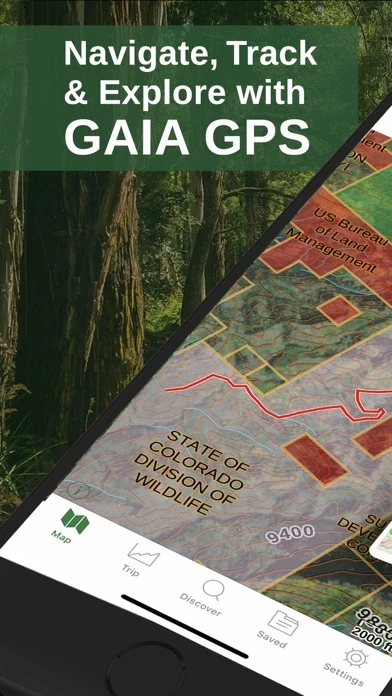
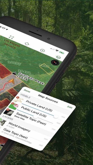
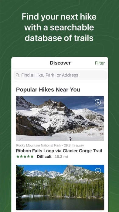
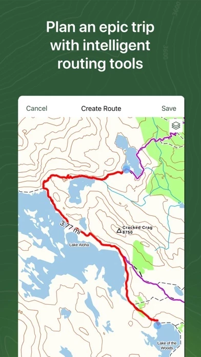
- Discover hiking trails and plan your own routes with Gaia Topo, the world’s most powerful backcountry map.
- Explore hundreds of professional maps, including Nat Geo Trails Illustrated, USFS, and hi-res satellite imagery.
- Take your maps offline so you always know where you are, even far from cell service.
- Use our intelligent route planner to create routes on the fly.
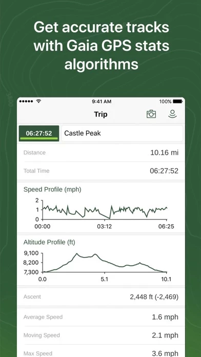
- Use our app as an altitude, elevation and distance tracker for each hike.
- Mark campsites and points of interest, drop photo waypoints.
- Get weather forecasts to stay on top of changing conditions.
- Discover camping and reserve sites right from the map.
- Find dispersed camping far from the crowds with public and private land boundaries and USFS maps.
- The premier offroad app for planning, navigating, and recording 4x4 and overlanding adventures.
- Identify avalanche terrain with slope angle shading and topographic information.
- Find the best trails curated by the team over at Trailforks.
- Gaia GPS is the preferred nav app for outdoor professionals.
- Free – limited maps, for online use only.
- Premium – full online and offline access to the map catalog; print custom maps.
Official Screenshots
Gaia GPS Pricing Plans
| Duration | Amount (USD) |
|---|---|
| Weekly Subscription | $99.94 |
**Pricing data is based on average subscription prices reported by Justuseapp.com users..
Product Details and Description of
Explore the world with Gaia GPS, your premier guide for finding trails around the world. Beloved by millions worldwide and featured in countless publications like the New York Times, Washington Post, and GearJunkie, Gaia GPS provides the best offline maps and navigation tools for your adventures. The wilderness is yours to explore. Ditch the growing crowds by creating your own routes, and always know where you are – even without cell service. HIKING, BACKPACKING, TRAIL RUNNING • Discover hiking trails and plan your own routes with Gaia Topo, the world’s most powerful backcountry map. • Explore hundreds of professional maps, including Nat Geo Trails Illustrated, USFS, and hi-res satellite imagery. • Travel with confidence – Take your maps offline so you always know where you are, even far from cell service. • Leave a breadcrumb on the map so you can always find your way back home. • Use our intelligent route planner to create routes on the fly. • Use our app as an altitude, elevation and distance tracker for each hike. • Mark campsites and points of interest, drop photo waypoints. • Get weather forecasts to stay on top of changing conditions. • From national parks to backcountry trails, our nav and hiking app has you covered. CAMPING • Discover camping and reserve sites right from the map. • Find dispersed camping far from the crowds with public and private land boundaries and USFS maps. • Mark campsites with waypoints so you can easily find them late at night or on your next trip. OVERLANDING • The premier offroad app for planning, navigating, and recording 4x4 and overlanding adventures. • Take topo maps, USGS, USFS, MVUM, public and private land maps offline so you can always find your way, even without cell service. • Plan expeditions on your desktop at home with intelligent route planning tools. • Reroute on the fly using your phone or tablet in the field thanks to snap-to-trail route building. • Drop customizable waypoints to mark campsites and points of interest. • Stay one step ahead of nature with precipitation forecasts and wildfire activity. • Display your maps, routes, and waypoints on your dashboard with Apple CarPlay. BACKCOUNTRY SKIING • Identify avalanche terrain with slope angle shading and topographic information • Get the avalanche forecast to stay safe on the mountain. • Record your ski tracks, view incoming weather and get SNOTEL data. • Track your location, even without cell service. MOUNTAIN BIKING • Find the best trails curated by the team over at Trailforks. • View trail difficulty, direction, and conditions. • Find new trails from local bikers to explore the wilderness around you. PROFESSIONAL USE • Gaia GPS is the preferred nav app for outdoor professionals. • Quickly route to GPS coordinates, view recent wildfires, and share maps, tracks, & waypoints with your team. • Mark hiking trails, routes, campsites, & water sources. • Share data with clients & fellow guides. MEMBERSHIP • Free – limited maps, for online use only. • Premium – full online and offline access to the map catalog; print custom maps. SIGNUP • Gaia GPS is part of the Outside Inc, family. Create an Outside account to access the map. MANAGE YOUR SUBSCRIPTION • TURN OFF auto-renewal via the main Settings app: http://support.apple.com/kb/ht4098 • Subscriptions automatically renew unless auto-renew is turned off at least 24 hours before the end of the current period. Your iTunes account will be charged for renewal within 24 hours of the end of the current period. • Your iTunes Account will be charged at confirmation of purchase. Terms of use: http://www.this app.com/terms_of_use/
Top Reviews
By The Strawman
Great App with a couple minor issues
Let me start by saying I use a Premium Subscription and absolutely love this app and use it nearly daily for both work and recreation. I does so much that it has become a must for use with my fieldwork. My only complaints are the randomized coloring when importing tracks and the was area shapes are created. Using this app professionally, I often need all of my shapes to be specific colors or all one color. Often I can just quickly adjust them in the app, but when I have projects with hundreds of shapes this is no longer a viable option and is very frustrating. Simply allowing bulk adjustment would solve this problem for me. The second issue regarding creating areas is that often when I try to move the dots that adjust the area, it grabs the screen and tries to move it instead... sensitivity issue maybe? In any case, these issues are not deal breakers... I love this app and will continue to use it, but hope that these two simple things will be addressed in the future. I know I’m not the only one that would like to see this! Thanks for a great app!!!
By eritchie007
Great tool for mapping motorcycle trips that use lots of off-road.
I’ve been using GAIA to map my rides for a couple of years now. I use it to note where I’ve been, and to mark places I’d like to go, rather than mapping out routes beforehand. I like the detail available in the layers of maps available, (just purchased membership so as to be able to download and utilize Canada backroads layer) the ability to run the app while phone is in airplane mode, and the relatively low power use in that mode. I’ve ridden across the country west to east and back again, and from south to north, and largely off-road. And have records of each day’s ride. I use it to map mountain bike rides and bicycle commutes, and keep multiple parent-folders current with each ride. I also like being able to share a link to my rides with family and friends. I know there are features I don’t use, but feel confident that their use would be pretty intuitive given the ease of use I experience with the features I do use.
By Julien velo
Great to plan routes for off-road riding
Downloaded the app and tested it for off-road motorcycle. The automatic tracing of a route over existing marked trails is an awesome feature that makes planning the route considerably easier than with Google Earth or Garmin Basecamp. I downloaded satellite image and usgs topo maps of the area I was riding in so I didn't need to rely on having network or not during the ride. Battery usage was reasonable and it can certainly last for 12 hours or more with every app turned off and airplane mode. The website is fairly good too. Only small complain is that the web app folder system is a little convoluted - it's not obvious at first where things go at first. The mobile app occasionally crashes while managing files, yet nothing was lost. Compare to a Garmin gps unit the only limitation is the device's gps accuracy and recording rate but it's no issue for off-road riding/driving, likely not an issue for hiking neither.