CalTopo Overview
What is CalTopo?
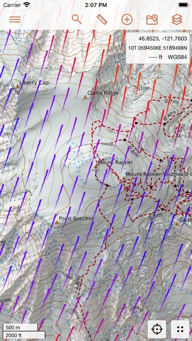
CalTopo for iOS is a mobile app that allows users to plan their backcountry adventures with offline topographic maps and aerial imagery, slope angle shading, viewshed analysis, and real-time SNOTEL and weather data. The app integrates seamlessly with the CalTopo website, allowing real-time syncing with the web application while still having cell service. Users can download mapping layers and maps they have created to guide them on their adventures and sync the record of their journey back to the CalTopo website.
Features
- Offline availability of Map Builder Topo, Map Builder Hybrid, Scanned 7.5', and FS Topo maps
- Availability of Marine Charts, FAA Sectionals, NAIP Imagery, Shaded Relief, USFS/NPS Visitor Maps, and Satellite Daily and Weekly Layers
- Overlays available include Contours, Map Builder Overlay, Slope Angle Shading, Parcel Data, Public Lands, Motor Vehicle Use, and Realtime weather and SNOTEL data
- Real-time syncing with the CalTopo website
- LIDAR slope angle shading available on/offline
- Requires Pro subscription for some features such as Weekly High Res layer and Parcel Data.
Official Screenshots


Product Details and Description of
this app for iOS extends your adventures from the desktop to the field. this app contains tools to plan your backcountry adventures including offline topographic maps and aerial imagery, slope angle shading, viewshed analysis, realtime SNOTEL and weather data, and many more options. The mobile apps integrate seamlessly with the this app website allowing realtime syncing with the web application allowing updates to maps and routes to be passed back and forth (while you still have cell service). If you're traveling off the grid you can download mapping layers and maps that you've created to help guide you on your adventures. When you're back you can sync the record of your journey back to the this app website. No more cumbersome exporting and importing from other apps. Plan your next adventure today! Layers Available: (*Indicates Offline Availability) Map Builder Topo* Map Builder Hybrid* Scanned 7.5'* FS Topo* Marine Charts FAA Sectionals NAIP Imagery (Various Years)* Shaded Relief USFS/NPS Visitor Maps Satellite Daily and Weekly Layers (Note: Weekly High Res layer requires Pro subscription) And more... Overlays Available: Contours* Map Builder Overlay* Slope Angle Shading* (LIDAR slope angle shading available on/offline) Parcel Data (Note: Requires Pro subscription) Public Lands Motor Vehicle Use* Realtime weather and SNOTEL data And many others...
Top Reviews
By DVChester
Sloooowww
Virtually unusable - takes way too long to pan the map. The browser version works fine 🤷🏻♂️