BaseMap: Hunting GPS Maps Software
Company Name: BaseMap Inc
About: BaseMap is provides cutting edge technology, innovation, and information that the customers really
want.
Headquarters: Bothell, Washington, United States.
BaseMap Overview
What is BaseMap? The BaseMap app is an outdoor app that can be used as a GPS and compass to map outdoor adventures. It allows users to navigate to trailheads, favorite places, markers, or anything they need to locate with its powerful search and GoTo features. The app also has an outdoor journal feature that allows users to capture, log, and share all their outdoor adventures with the BaseMap community. Additionally, the app has a harvest log, Huntwind, and weather center, offline GPS and tracking, Geardrop, in-app 3D satellite imagery, Google Earth integration, and map layers.
Features
- Mobile GPS that allows users to know their exact location even without cellular or WiFi service
- XDR (Exact Direction & Range) Navigation Tool that immediately shows the exact distance between the user and their desired destination
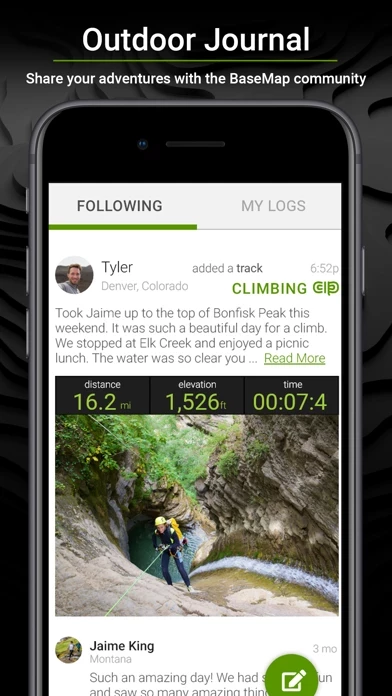
- Outdoor Journal that allows users to capture, log, and share all their outdoor adventures with the BaseMap community
- Harvest Log that allows users to log their hunts as detailed as they'd like
- Huntwind & Weather Center that provides wind forecast to better plan the hunt and know the exact day and time to hunt a particular stand
- Offline GPS and Tracking that allows users to cache maps for offline use and use anywhere, even without service
- Geardrop that allows users to drop their marker closest to the GearDrop marker and win free gear
- In-App 3D Satellite Imagery that allows users to see the terrain from every angle
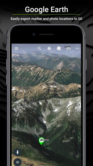
- Google Earth Integration that allows users to export markers and view them right in Google Earth
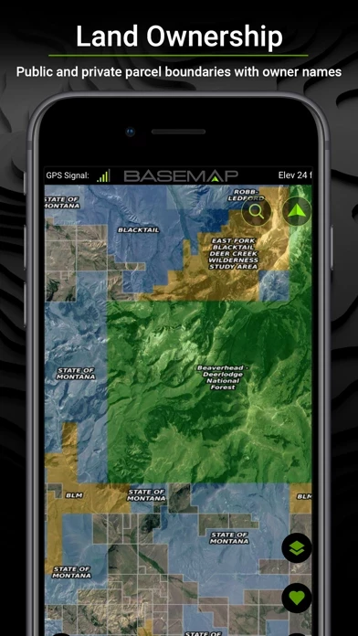
- Map Layers that include over 700 layers and growing, nationwide color-coded Govt lands, nationwide private parcel boundaries & owner names, water depths for East coast, West, Coast, Gulf coast, & over 4,000 U.S. lakes, nationwide hiking trails, nationwide wildfires & timbercuts, nationwide wilderness & roadless areas, state-specific hunting layers including hunting unit boundaries, private hunting opportunities, WMA’s & more, and multiple topography & satellite imagery basemap options
- Better Experience that includes nationwide plans so users never have to be restricted to just one state, fastest layer rendering speed, and sync all map data between the phone and the BaseMap web application
- Subscriptions that include Basic (Free), Pro ($9.99/mo or $34.99/yr), and Hunting Research ($9.99/yr) with different features and benefits.
Official Screenshots


BaseMap Pricing Plans
| Duration | Amount (USD) |
|---|---|
| Billed Once | $27.24 |
| Monthly Subscription | $9.99 |
| Yearly Subscription | $0.00 |
**Pricing data is based on average subscription prices reported by Justuseapp.com users..
Product Details and Description of
***Now the Official Hunting App of the Bone Collector Brotherhood*** this app is the only outdoor app you will ever need. Turn your phone into a GPS and compass to map your outdoor adventures and interact with the this app community. MOBILE GPS • Know your exact location even without cellular or WiFi service • See where you are in relation to property boundaries, roads, trails, peaks, or boundaries • Navigate to trail heads, favorite places, markers, or anything you need to locate with our powerful Search and GoTo features. XDR (Exact Direction & Range) NAVIGATION TOOL • Immediately know the exact distance between you and your desired destination. OUTDOOR JOURNAL • Capture, log and share all your outdoor adventures with the this app community • Real-time location sharing so friends can see where you are in case of emergency (connection reqd.) • SmartMarkers - Automatically capture the weather conditions at the time you add a marker. HARVEST LOG • Log your hunts as detailed as you'd like. Record your hunt type, species/size, weapon, unit/GMU & much more. HUNTWIND™ & WEATHER CENTER • Wind forecast to better plan your hunt. • Know the exact day and time to hunt a particular stand and visualize wind direction and scent drift in relation to your location. • Forecasts, temperature, moon phase, sunrise/sunset, wind, and more. OFFLINE GPS and Tracking • Cache maps for offline use and use anywhere…even without service. • Save as many offline maps as you want with unlimited caching (Pro). • Know exactly where you are in real time even without cellular coverage. GEARDROP • Drop your marker closest to the GearDrop marker & win free gear. IN-APP 3D SATELLITE IMAGERY • As close to boots-on-the-ground as you can get • Tilt & rotate the map to see the terrain from every angle GOOGLE EARTH INTEGRATION • Export markers and view them right in Google Earth • View the terrain in true 3D MAP LAYERS • Over 700 layers and growing • Nationwide Color Coded Govt Lands • Nationwide Private Parcel Boundaries & Owner Names • Water depths for East coast, West, Coast, Gulf coast, & over 4,000 U.S. lakes • Nationwide Hiking Trails • Nationwide Wildfires & Timbercuts • Nationwide Wilderness & Roadless Areas • State specific hunting layers including hunting unit boundaries, private hunting opportunities, WMA’s & more • Multiple Topography & Satellite Imagery this app options • Much more BETTER EXPERIENCE • Nationwide plans so you never have to be restricted to just one state. • Fastest layer rendering speed • Sync all your map data between your phone and the this app web application. SUBSCRIPTIONS Basic (Free) • No Ads • Connect with friends • Nationwide parcel boundaries • Hybrid 3D Imagery (map tilt). • GoTo Navigation • Nationwide Roads, Trails & Points Of Interest • Nationwide Lakes, Rivers & Streams • Hunting Units • GPS Location & Tracking • Multiple Topo & Imagery this app options Pro ($9.99/mo or $34.99/yr) • Everything in Basic plan • Access to over 700 Layers • Unlimited Data & Offline Use • Nationwide parcel owner names • Nationwide color-coded government lands • 3D Earth view • Google Earth Integration • Import/Export KML and GPX with this app online application • Real-Time location sharing Hunting Research ($9.99/yr) • In-depth hunting research tools • Filter hunting units by species • Hunting season dates for every unit and species • Detailed harvest success graphs for Western big game species • Subscriptions automatically renew unless auto-renew is turned off at least 24-hours before the end of the current period. • Subscriptions and auto-renewal may be turned off any time in your Apple account • Your Apple account will be charged for renewal within 24-hours prior to the end of the current period, and identify the cost of the renewal. For questions or more information, contact us at: support@this app.com Privacy policy: https://www.this app.com/privacy-policy/ Terms of use: https://www.this app.com/terms-of-use/
Top Reviews
By warriorsrus
Simply AMAZING!
For years I have been looking for a way or an app so that I could view boundary lines in real time and not just wonder where I was in relationship to them. This app solves that and so much more. I have been searching for land for the past few years to fit the house that I’m looking to build. Not only will this app allow you to measure the distance of the boundary lines, you can also draw shapes on it to see how your home or project will fit on it. Another handy feature is the ability to cache and save an area so that when you’re off-line you have a way to view and use. The online videos are short and extremely helpful to get using this app in less than five minutes. The only drawback I have found after using for a week is that some of the land ownership information is a bit out of date, sometimes as much as four years. You are not supposed to have access to this information in the basic free version however when you use the cache map you can see it, that’s how I know. Also read other reviews That mentioned the same issue. Not a huge concern for me and considering I’m using the basic, free version. In summary, I just can’t say enough good things about this app period. What have you got to lose.....try it!
By dallinh64
The BEST mapping app out there!
Great app! Much more detail and options for layering than other apps currently on the market! It honestly is the best hand held mobile app there is. I have TONS of experiences with the competition and this app takes the cake! With so many more layering and in depth mapping options it’s worth every little penny for the membership and it’s a fraction of the cost of most other applications. And the newest addition of the GearDrop is so nice! Literally all you have to do is have the app downloaded, drop a pin and you can win hundreds of dollars in FREE gear no strings attached! If you’re sitting in the fence with downloading the app, just do it! Sign up for the free trial and I promise you you’ll not stop there. For this price it’s a no brainer current and the most accurate info for all 50 states is at the palm of your hands.
By BeyonderHill
Still trying to figure it out
The potential is incredible. I can't figure out how to make a map section available offline, or know which maps have offline availability. I was just up the canyon this morning trying to use it but I didn't have a signal and suddenly the whole app became useless because I couldn't see anything. So trying to control offline content is my current focus of attention. The online content is awesome. Just awesome. On my motorcycle I would use this over my Garmin if I could get it to update a bit quicker. Also, I still have to buy another app in order to get disbursed camping sites. No disbursed camping info. I want to use this to find out of the way places to camp and it almost does it all. But not quite. This only four stars.