Pocket Earth PRO Software
Company Name: GeoMagik LLC
About: GeoMagik developes high performance geoinformation systems utilizing community driven open data
sources.
Headquarters: Santa Cruz, California, United States.
Pocket Earth PRO Overview
What is Pocket Earth PRO?
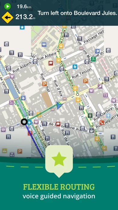
Pocket Earth is a travel app that provides detailed worldwide maps and travel guides, topographic contour maps for the outdoors, and works completely offline even with GPS. It is great for use abroad or in the wilderness, with no data roaming charges. The app also offers online routing with offline voice guidance and many other features.
Features
- Beautiful Retina quality maps at a fraction of the size
- Detailed and interactive worldwide maps with more than 100,000 places
- Access to maps online and offline, saving on data roaming costs
- Personalization of maps to show the desired information
- Online routing with voice-guided turn-by-turn directions and the ability to save multi-stop itineraries for offline navigation
- Online street address search and contacts integration
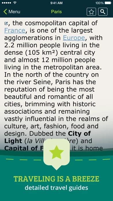
- More than 25,000 detailed Wikivoyage Travel Guides and more than 1 million Wikipedia articles in 7 languages, all offline
- Customizable pins and favorites groups with the ability to add notes and mark and share favorite spots
- Share maps links and current location via SMS, Facebook, WhatsApp, Email, etc.
- An in-app purchase option for topographic maps with high performance, high accuracy 10m / 50ft contour display worldwide
- Hiking and cycling maps, great for geocaching and getting off the track
- GPS track recording to see the route taken, great for hikes, cycling, and off-road
- Import/export support for GPX and CSV files, share with friends using PE Archives
- Displays and lets you search for map coordinates, including DD, DDM, DMS, MGRS, UTM/UPS, GeoHash, and what3words
- Numerous GPS settings for preferred configuration, including compass and heading arrow or rotation, look ahead mode, accuracy, and recording settings.
Official Screenshots


Product Details and Description of
• Detailed worldwide maps and travel guides • Topographic contour maps for the outdoors • Works completely offline even with GPS • Great when abroad or in the wilderness, NO data roaming charges • Online routing with offline Voice Guidance and much more! « Reviews » “I love this technology” – Natali Morris, Tech Reporter, NBC’s Today Show Editor's Pick Best Offline Map App – thedigitaltrekker.com “The best travel app in the world… Don’t leave home without it!” – bonvoyageurs.com “Very impressive app with unmatched features.” – toptenreviews.com « Maps » • Beautiful Retina quality maps at a fraction of the size! The fastest and most beautiful offline maps on the App Store! • Detailed and interactive worldwide maps! More than 100,000 places & completely free! • Access your maps online and offline! Saves on data roaming costs! • Personalize the maps to show the info you want! • Online Routing with voice guided turn by turn directions. Save your multi-stop itineraries for offline navigation! • Online street address search and contacts integration! • Did we mention everything is offline? Works anywhere- cities, small towns, even in the middle of nowhere. Never any roaming charges. We dare you to try it! « For the Traveler » • Find out about thousands of interesting places - hotels, restaurants, bars, tourist sites, even get metro and public transit info! • Our super wide area Nearby search is also super fast! • Have all the travel info you need with more than 25,000 detailed Wikivoyage Travel Guides and more than 1 million Wikipedia articles in 7 languages! All offline of course! • Customizable Pins and favorites groups! Add notes and mark and share favorite spots! • Share maps links and your current location (SMS, Facebook, WhatsApp, Email, etc)! « For the Adventurer » • An in-app purchase option offers topographic maps. Get high performance, high accuracy 10m / 50ft contour display world-wide. The ONLY offline app that lets you download large areas, even entire countries! Contours are displayed on our existing maps for all Activities. • Hiking and Cycling maps! Great for geocaching and getting off the track! • GPS track recording lets you see what route you took! Great for hikes, cycling and off road! Never get lost again! • Import/Export support for GPX and CSV files! Share with friends using PE Archives. • Displays and lets you search for map coordinates (including DD, DDM, DMS, MGRS, UTM/UPS, GeoHash, and what3words)! • Numerous GPS settings for your preferred configuration including compass and heading arrow or rotation, look ahead mode, accuracy and recording settings. ...and much more - so try it out! « How's it Work? » Just select the cities, regions, or even whole countries you want to download, and it will be available for offline use, complete with information on thousands of POIs (Points of Interest), travel guides and Wikipedia articles. To do this we utilize community driven open data from a number of amazing projects. We use some magik to compress and package it in a format optimized for mobile devices. Pocket Earth then renders its beautiful vector maps on your device using our OpenGL ES based MagikMap technology. To learn more about Pocket Earth or the community driven open data sources that we use, please visit our website. Don’t forget this: 1. Using the GPS features of this app can significantly affect battery life. Only leave GPS enabled when you need to use it. Continued use of GPS running in the background can dramatically decrease battery life. Pocket Earth only uses GPS in the background for route navigation and gps track recording features. 2. This app uses data from the amazing community driven open mapping project called openstreetmap.org! Coverage detail may vary by region, please visit our website to check the map detail for your regions of interest. 3. Does not currently support all asian texts on the map (Chinese, Japanese, etc).
Top Reviews
By Dan Philly
Best offline maps solution
This might be my first app review but I felt compelled to write one because I don’t believe this app gets enough recognition. I like to do a lot of hiking and of all the apps I’ve tried (All Trails, Gaia, Avenza, OffMaps, MapMyHike, etc..) this is by far the best and most feature-filled one. Downloading maps is a breeze and the amount of detail that can be seen is surprising give how little storage space the downloads occupy. It’s very easy to import and save gpx tracks and saving offline driving directions is a cool feature you don’t see in other apps. One feature I would love to see however is the ability to draw/plan routes within the app (with distance and elevation gain stats). In addition to all the cool feature, this is also the cheapest solution considering that it’s a one-time payment instead of a subscription based model. I seriously can’t recommend this app enough!!
By Jmeador74
Great Offline Maps
Great to use on older phones that no longer have cellular service. Load the app, download the maps and just use the internal gps with the map software. For $5 you can download the topographical maps, if you know how to read them. I’ve always just wanted mapping software that didn’t rely on having data available. Now I can just download while on WiFi and go. If you are running low on memory, you can just download the states you are in or visiting individually. From time to time I have noticed that maps are deleted when the app is updated. I did have to reload maps, but if I was already out and about I would just download the state and I can always restore my purchase of the topo maps and be on my way. Have fun, enjoy and get out and go explore.
By Peas and Tea
Love it - and I'm a map geek
I LOVE this map. I first used it many years ago with my iTouch and now have the Pro version on my iPhone. You can navigate with iPhone even if you have no cell coverage; the GPS still works. I always pre-download maps when I travel. I can then navigate off line, which saves data fees as well as battery. The ability to switch which maps are downloaded is great, and very easy. I can for example download British Columbia topo maps for a backcountry trip; then later remove it before downloading Italy for my next trip. The level of detail and the number of "points of interest" is fantastic! I’ve even used it to navigate the Paris metro system! I d like to see more icon choices for “favorites” I save. A way to indicate a trailhead, or a picture of a car come to mind. Another update I’d like to see is that I’d like to be able to search for routes or tracks that are “Nearby”. The only way to find them currently is to search “Groups & Filters” by name date or user. Since I have dozens if not hundreds of Tracks and Routes, this is cumbersome. I usually don’t remember the name or date, and the user is always me, so I must scroll through the entire list.