Magic Earth Navigation Maps Overview
What is Magic Earth Navigation Maps? Magic Earth is a navigation app that offers optimal routes for driving, biking, hiking, and public transportation. It uses OpenStreetMap data and a powerful search engine to provide accurate and reliable directions. The app also features offline maps, AI dashcam, CarPlay compatibility, traffic info, public transport options, and weather forecasts.
Features
- Offline maps powered by OpenStreetMap for 233 countries and regions
- 2D, 3D, and Satellite map views
- Detailed route information including surface, difficulty, distance, and elevation profile
- Points of interest information from Wikipedia articles
- Nearby parking spot suggestions
- Regular free map updates
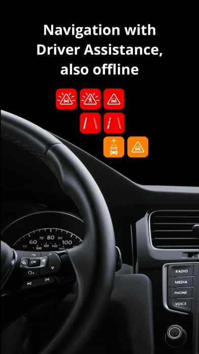
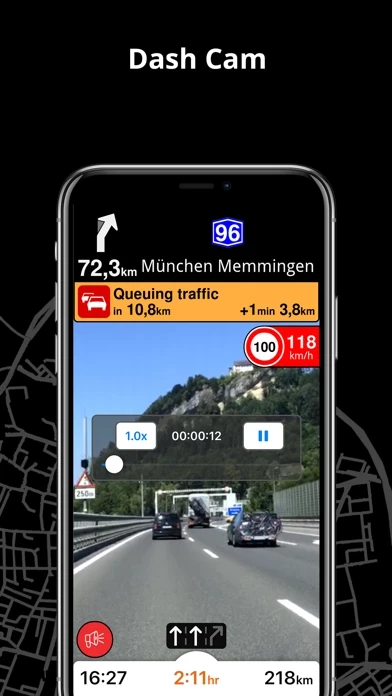
- AI dashcam with Driver Assistance warnings and Dash Cam functionality
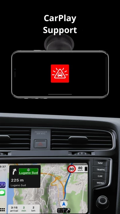
- CarPlay compatibility
- Fastest or shortest route options for driving, biking, walking, and public transportation
- Multiple waypoints planning
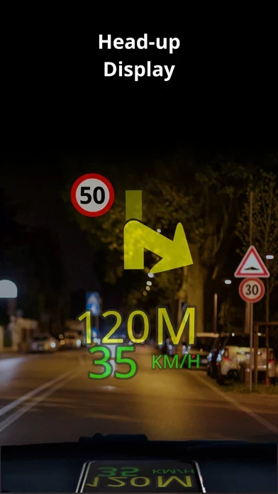
- Head-up Display (HUD) feature for safe driving
- Precise turn-by-turn navigation and lane assistance
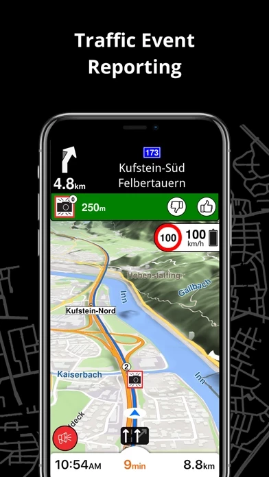
- Speed camera notifications and current speed limit information
- Real-time traffic info and alternative route suggestions
- Public transportation options including walking directions, transfer times, departure times, number of stops, and cost
- Wheelchair or bike-friendly public transportation options
- Local weather forecasts for favorite locations
- Privacy-first policy with no tracking, profiling, or trading of personal data.
Official Screenshots
Product Details and Description of
Find the best route to your destination even without an internet connection. Magic Earth uses OpenStreetMap data and a powerful search engine to offer you the optimal routes for driving, biking, hiking, and public transportation. PRIVACY FIRST! • We do not track you. We do not profile you. We do not trade in your personal data; moreover, we do not have it. MAPS • Save big on mobile internet costs and navigate reliably with offline maps powered by OpenStreetMap. 233 countries and regions are ready to be downloaded. • Choose between 2D, 3D, and Satellite map views. • Get ready for travel and know every detail of your route like surface, difficulty, distance and elevation profile. • Learn more about the points of interest near you from Wikipedia articles. • Spot nearby parking places to easily park your car. • Stay up-to-date and enjoy regular free map updates. AI DASHCAM • Improve safe driving and avoid accidents. Receive alerts to potential problems on the road and record your trip. • AI DashCam features Driver Assistance warnings and Dash Cam functionality. • Avoid collisions and accidents with Driver Assistance warnings: Headway Warning, Forward Collision Warning, Pedestrian Collision Warning, Lane Departure Warning, Leaving Lane Warning, Stop & Go Assist. • Record the road ahead during navigation to have an aid in the event of a collision or incident. • Driver Assistance warnings and Recordings are available when the device is on a car mount in landscape mode, with a clear view of the road ahead. CARPLAY compatibility • Connect to Apple CarPlay and enjoy the ultimate navigation experience. NAVIGATION • Find the fastest or the shortest route to your destination when you travel by car, bike, on foot or with public transport. • Plan your route with multiple waypoints. • Stay safe with the free Head-up Display (HUD) feature which projects the most important navigation info onto the windshield of your car. • Know in advance which lane to take with precise turn-by-turn navigation and lane assistance. • Get notified about speed cameras and stay up to date with current speed limits. TRAFFIC INFO • Get real-time traffic info, updated every minute. • Discover alternative routes that avoid traffic jams and save you time on the road. PUBLIC TRANSPORT • Get around town quickly and easily. Choose from public transit routes that combine all transportation modes: bus / metro / subway / light rail / train / ferry • Get walking directions, transfer times, departure times, number of stops. And when available, the cost. • Find wheelchair or bike-friendly public transportation. WEATHER • View current temperature and local weather forecasts for your favorite locations. • See what weather conditions to expect in the next hours and view the forecast for the next 14 days. NOTES: * Some features are not available in all countries. * Some features require internet connection.
Top Reviews
By Hllakcn
Top1 in Class
I have been using this company’s navigation in nearly 20 countries and 6 United States since 2007 (Route66, Navigate and finally Magic Earth). The good part is the city center and suburban roads selected by the application are always reasonable and had the best views in a touristic road trip. It is the excellent and number 1 application for navigation. I wish Safety Lens could be used without extra hardware with only camera and internet connection.
By Alabama doc
Excellent Program and Versatile Map Library
I have used this application in many countries. This is an excellent program that you can use off-line by downloading Maps for the country or region you need. Unlike some programs, you can be more specificabout which maps to download so that you do not fill up your iPhone with much larger maps than you need.
By luisluigi639
Best App Ever
I love this app, this app is so useful for my when I’m routing her and there with no problems, it’s better that some other apps (like Karta) which doesn’t update its maps as regularly. The graphics are good to and I like the turning lane symbols at the bottom. The only thing that’s needed is that there is no reference to state routes on the map. I’d be cool if they added them.