PRO CHARTS Overview
What is PRO CHARTS?
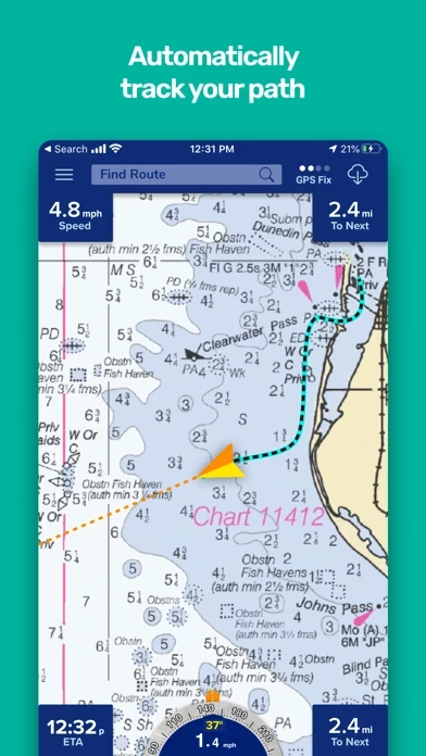
MiraTrex PRO CHARTS™ is a marine navigation system that helps fishermen, sailors, divers, and other water enthusiasts to navigate safely. The app provides high-resolution NOAA nautical chart coverage with depths for all U.S. coastal areas, the Great Lakes, major U.S. river systems, and Brazil plus global high-level nautical charts. It also offers easy one-touch Waypoint and Route creation, Buddy-tracking feature, Float Plan creation, point-and-steer navigation, and fully indexed point of interest (POI) database. The app is available for iPhone and iPad and can be used offline without an internet connection.
Features
- High-resolution NOAA nautical chart coverage with depths for all U.S. coastal areas, the Great Lakes, major U.S. river systems, and Brazil plus global high-level nautical charts
- Easy one-touch Waypoint and Route creation
- Buddy-tracking feature to see and meet up with friends on the water
- Float Plan creation and location history forwarding to search and rescue personnel in case of an emergency
- Point-and-steer navigation with a large on-screen compass and red heading bug
- Offline use without an internet connection
- Real-time position tracking and track history recording
- Fully indexed point of interest (POI) database including weather, aids to navigation (markers and lights), obstructions, tides, currents, and more
- Base app with limited features is free
- 14-day trial of all premium features is free
- All premium features (Monthly) - $2.99
- All premium features (Annual) - $29.99 (Save 16%, about 2 months free)
- Automatic chart updates based on NOAA chart corrections
- Third-party Bluetooth GPS units are available to enable GPS for iOS devices such as WiFi-only iPads that do not include a GPS receiver
- Privacy policy and terms of use are available on the app's website.
Official Screenshots


PRO CHARTS Pricing Plans
| Duration | Amount (USD) |
|---|---|
| Monthly Subscription | $2.99 |
**Pricing data is based on average subscription prices reported by Justuseapp.com users..
Product Details and Description of
MiraTrex PRO CHARTS™ is a powerful, yet easy-to-use marine navigation system. Whether you’re a fisherman, weekend cruiser, sailor, diver, jet-skier, or an offshore captain needing to find an exact location hundreds of miles offshore, PRO CHARTS™ will get you there and back home safely – with nothing more than your iPhone or iPad. Key Features: • High-resolution NOAA nautical chart coverage with depths for all U.S. coastal areas, the Great Lakes, major U.S. river systems, and Brazil plus global high-level nautical charts. Charts are automatically updated based on NOAA chart corrections. • Easy one-touch Waypoint and Route creation. Pre-plan your routes at home or create them at sea with equal ease. Just touch the screen to create new waypoints and routes. • Find your friends on the water. With our new Buddy-tracking feature, you can see and meet up with your friends while you’re out on the water. If you’re on your secret spot and don’t want to be seen, you can hide your location with the touch of a button. • Stay safe. Easily create and send a Float Plan of your trip to a friend or family member. Your Float Plan and location history can be forwarded to search and rescue personnel in case of an emergency. • Easy point-and-steer navigation. The red heading bug on the large on-screen compass always directs you to the next point on your route. Navigation is as easy as pointing your boat at the heading bug to stay on course. • No Network. No Problem. PRO CHARTS™ is designed so no internet connection is required to view your charts while out on the water. You simply download in advance any charts you’ll need at sea with the touch of a button. • Record your tracks. Track your position in real-time and later view your track history. • Fully indexed point of interest (POI) database including weather, aids to navigation (markers and lights), obstructions, tides, currents, your buddies, and more. Website: www.miratrex.com -------------------- Plans: Base app with limited features - Free 14 day trial of all premium features - Free All premium features (Monthly) - $2.99 All premium features (Annual) - $29.99 (Save 16%, about 2 months free) -Payment will be charged to your iTunes Account at confirmation of purchase. -Your subscription automatically renews unless auto-renew is turned off at least 24 hours before the end of the current subscription period. -You will be charged for renewal within 24 hours prior to the end of the current period, for the same duration and at the current subscription rate for that product. -You can manage your subscriptions and turn off auto-renewal by going to your Account Settings in the Apple Settings app after purchase. -No cancellation of the current subscription is allowed during active subscription period. This does not affect your statutory rights. -Any unused portion of a free trial period, if offered, will be forfeited when you purchase a subscription. -We will be collecting information about your use of the app both when you are online and offline. To find out more please see our privacy policy. -------------------- By purchasing a subscription or downloading an app you agree that you have read and accept our Privacy Policy and Terms of Use. http://www.miratrex.com/this app/terms-of-use/ http://www.miratrex.com/this app/privacy/ NOTE: Continued use of GPS running in the background can dramatically decrease battery life. Though PRO CHARTS™ will function without a GPS as a chart reader, a GPS-enabled device is required for point-to-point navigation. Third-party Bluetooth GPS units are available to enable GPS for iOS devices such as WiFi-only iPads that do not include a GPS receiver. For offline use where no Internet connection is available, charts must be pre-cached while still on-line and connected, any charts downloaded while online will be available for offline use.
Top Reviews
By ShibumiCaptn1
simple charting app review...
Over the past few months I have tinkered with several charting apps available ranging from free to upwards of $30 and I have come to the conclusion that simple charts is by far the easiest to use and most complete app available. The app is the perfect compliment to my onboard system and functions smoothly as I go in and out of cellular or Internet service. As the name indicates is fairly easy to operate and the learning curve is low as I compare it to most of the others. The feature set is much more than I anticipated and caters very well to my needs. The documentation is on the light side but I found the FAQ section useful, the support email allowed me to contact the developers and get the remaining questions I had answered. I was pleasantly surprise at the quick turnaround on the email and the tone and level of detail provided led me to believe they actually cared. highly recommended.
By ELN9798
Simple charts review
Very impressed with the app. We have taken it along on a handful of trips down the ICW from southern VA to Key Largo. The instruments panel including location, speed, distance, etc has matched my garmin installed onboard in every instance that they were side by side. Love the detail in the raster charts rather than the electronic charts on the garmin much more appealing to look at. My wife and I really enjoyed the course export functionality that allowed us to share our course with friends which has come in handy. Really like the app and have already gotten more than $10 worth of enjoyment out of it. Hopefully the developers will continue to add new features. We requested several features which we would find useful and think others on the water would as well. They stated that they would be adding these features to a list of enhancements they have planned so time will tell if they get added.
By CaptBeerye
Fozen
Decent but often freezes and every time I try to contact support I never receive a response