Pocket Earth Maps Overview
What is Pocket Earth Maps? Pocket Earth is a travel app that provides detailed worldwide maps and travel guides, topographic contour maps for outdoor activities, and works completely offline even with GPS. It is great for use abroad or in the wilderness, with no data roaming charges. The app offers online routing with voice guidance and many other features. It is available for download on the App Store.
Features
- Beautiful Retina quality maps at a fraction of the size
- Detailed and interactive worldwide maps with more than 100,000 places
- Access to maps online and offline, saving on data roaming costs
- Personalization of maps to show the information you want
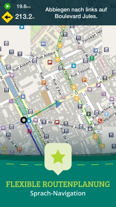
- Online routing with directions and the ability to save multi-stop itineraries for offline voice-guided navigation
- Online street address search and contacts integration
- More than 25,000 detailed Wikivoyage Travel Guides and more than 1 million Wikipedia articles in 7 languages, all offline
- Customizable pins and favorites groups, with the ability to add notes and mark and share favorite spots
- Share maps links and your current location
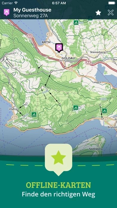
- In-app purchase option for topographic maps with high performance, high accuracy 10m/50ft contour display worldwide
- Hiking and cycling maps, great for geocaching and getting off the track
- GPS track recording to see the route taken, great for hikes, cycling, and off-road activities
- Import/export support for GPX and CSV files, with the ability to share with friends using PE Archives
- Displays and lets you search for map coordinates in all common formats
- Numerous GPS settings for preferred configuration, including compass and heading arrow or rotation, look ahead mode, accuracy, and recording settings.
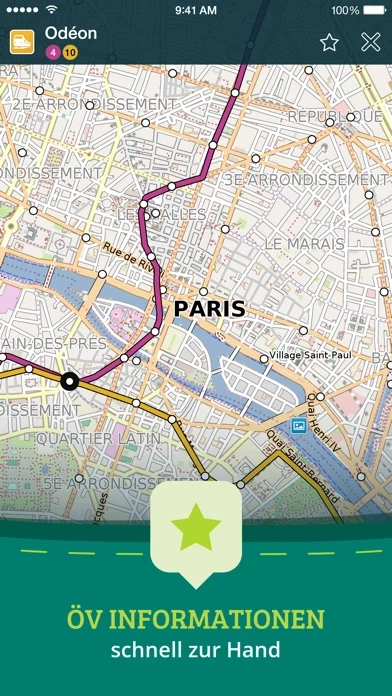
Official Screenshots


Product Details and Description of
Have fun getting lost with Pocket Earth! • Detailed worldwide maps and travel guides • Topographic contour maps for the outdoors • Works completely offline even with GPS • Great when abroad or in the wilderness, NO data roaming charges • Online routing with Voice Guidance and much more! • We give you one offline city for free, in-app upgrade to access unlimited worldwide offline maps and topographic maps feature. Bonus: All of Africa Standard maps are always free, and other rotating locations. « Reviews » “I love this technology” – Natali Morris, Tech Reporter, NBC’s Today Show Editor's Pick Best Offline Map App – thedigitaltrekker.com “The best travel app in the world… Don’t leave home without it!” – bonvoyageurs.com “Very impressive app with unmatched features.” – toptenreviews.com « Maps » • Beautiful Retina quality maps at a fraction of the size! The fastest and most beautiful offline maps on the App Store! • Detailed and interactive worldwide maps! More than 100,000 places! • Access your maps online and offline! Saves on data roaming costs! • Personalize the maps to show the info you want! • Online Routing with directions. Save your multi-stop itineraries for offline voice guided navigation! • Online street address search and contacts integration! • Did we mention everything is offline? Works anywhere- cities, small towns, even in the middle of nowhere. Never any roaming charges. We dare you to try it! « For the Traveler » • Find out about thousands of interesting places - hotels, restaurants, bars, tourist sites, even get metro and public transit info! • Our super wide area Nearby search is also super fast! • Have all the travel info you need with more than 25,000 detailed Wikivoyage Travel Guides and more than 1 million Wikipedia articles in 7 languages! All offline of course! • Customizable Pins and favorites groups! Add notes and mark and share favorite spots! • Share maps links and your current location! « For the Adventurer » • An in-app purchase option offers topographic maps. Get high performance, high accuracy 10m / 50ft contour display world-wide. The ONLY offline app that lets you download large areas, even entire countries! Contours are displayed on our existing maps for all Activities. • Hiking and Cycling maps! Great for geocaching and getting off the track! • GPS track recording lets you see what route you took! Great for hikes, cycling and off road! Never get lost again! • Import/Export support for GPX and CSV files! Share with friends using PE Archives. • Displays and lets you search for map coordinates in all common formats (including DD, DDM, DMS, MGRS, UTM/UPS, GeoHash, and what3words)! • Numerous GPS settings for your preferred configuration including compass and heading arrow or rotation, look ahead mode, accuracy and recording settings. ...and much more - so try it out! « How's it Work? » Just select the cities, regions, or even whole countries you want to download, and it will be available for offline use, complete with information on thousands of POIs (Points of Interest), and optionally, topographic maps, travel guides and Wikipedia articles. To learn more about Pocket Earth or the community driven open data sources that we use, please visit our website. Don’t forget this: 1. Continued use of GPS running in the background can dramatically decrease battery life. Only the GPS Route Navigation and GPS Track Recording features will use the GPS when running in background. 2. This app uses data from the amazing community driven open mapping project called openstreetmap.org! Coverage detail may vary by region, please visit our website to check the map detail for your regions of interest. 3. Does not currently support all asian texts on the map (Chinese, Japanese, etc).
Top Reviews
By Dave The candy man
Great maps
Great site. You find where your going and open the map then keep that spot and your set
By Drbobgold
One of my favorite Apps
Before leaving for a Danube River cruise, I downloaded all of the maps for the Eastern European countries, as well as several for the USA. They didn't take up much space, but were incredible, both while walking and driving. I was amazed to find out how much additional information was available everywhere with Wikipedia references that were quite extensive and that went far beyond what our local guides had given us, even in remote locations that I had never even previously heard of. While walking I was able to put in a street or address, and find my way to the location while offline. This worked well, but of course the one much to be desired improvement would be the ability to get turn by turn directions while offline, as the destination is drawn as a straight line from location to destination. However it is constantly upgraded as you move in the direction of your destination, so that it does take you there. We are a traveling family, and I have urged everyone to make the purchase. It is probably the best few bucks I have ever spent.
By calmanp
Great map for foreign holiday
Used this App extensively during a recent 7 week hiking and cycling holiday in Europe. Used it daily. Wouldn't want to be without it. How I used it: 1. Offline maps. If you have a limited data plan or are traveling in an area with poor cellular data, the offline maps function is huge. You can put your phone in airplane mode and still have full map functionality. Google maps will not work in areas without cellular data. Even if you have lots of data, putting your phone in airplane mode saves tons of battery power, keeps your charge up through long days of touring. 2. GPX functionality. I downloaded some cycling routes from a web site and was able to upload these on my iPhone and visualize these on the Pocketearth App. Similarly, I was able to record my rides and save them as GPX files, which I could then share with friends. This is an inexpensive introduction to the world of digital mapping and GPX. 3. Hiking. We downloaded GPX files of our hiking route and during the hike were able to check we were on the right path. Given that we were hiking on unmarked trails, this was incredibly reassuring that we would not get lost. Could also track how many miles we walked. 4. Altitude. The altitude was within a few metes of both the topographic map and a friend with a $200 altimeter. Amazing that you can get this for only $10! One criticism: cannot follow an existing GPX track AND simultaneously record one's own track.