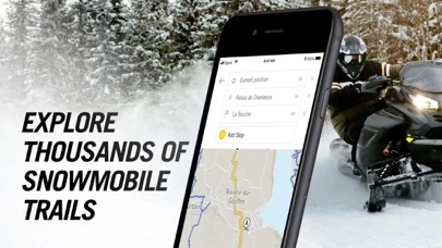
The snowmobile trails are only visible when you zoom way in on the map. What good is that for? When you’re needing to decide the best way from point A to B, you need to zoom out on the map to determine the best route and which trail to take. As you zoom out, the trails disappear and the map program shows only streets and highways. I’m on a sled for gods sake, I don’t give a rip about highway roads. I need the SNOWMOBILE trails! It is a snowmobile trail mapping app for crying out loud! Have the developers of BRPGOMapsNavigation ever snowmobiled? All this development on BRPGOMapsNavigation about saving your ride so your friends can see where I rode? Huh? Who cares about that? Have any of you ever wished “Boy, I wish I could have Google Maps save my trip to the store today so my buddies could see which way I drove my car today.” “Look Charlie, George rode 8.2 miles to work today and he went by Larry’s farm on the way!” Who does that? Maybe they should hire me, a snowmobiler, to help tell them how snowmobile trail map software should operate. Ever think of adding gas stations to the map? Novel concept.
Ok. I came back and I’m editing this review one month later…
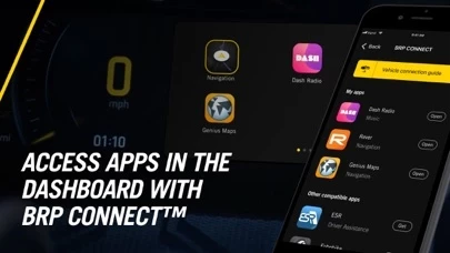
I’ve got to hand it to the developers, they have listened and made BRPGOMapsNavigation actually very nice while plugged in to the snowmobile cluster. The trick is, and I implore all of you to go buy a new charging cord from your phones manufacture, not a generic cheap one, and clean the lint out of your phones charging female plug before connecting to your snowmobile cluster. The bouncing around over the trails will cause your old/worn cord to not plug into your phone tight enough to keep a good connection. Once you use a new cord, BRPGOMapsNavigation works great on the cluster. The turn by turn navigation over the trails here in northern Minnesota is a game changer. It works great and once you get used to how the developers want you to use the phone to plan your route, or go to a destination, it is nothing but fantastic. No more cold hands digging your phone or trail map out of your pocket. And keeping your phone charged all day is a nice bonus.
Now how about the developers allow community edits on the map to add parking spots, gas, food, or most importantly trail conditions? It would be nice to tell my fellow Ski Doo riders where the groomer has been, or more importantly where not to go if trails are rough.
Good job developers, you’ve updated and fixed BRPGOMapsNavigation very nicely!