TrailLink: Bike, Run, Walk Reviews

TrailLink: Bike, Run, Walk Reviews

Published by on 2023-07-14

About: TrailLink is the ultimate trail-finder app to help you stay active and get
outdoors. Enjoy full-length trail descriptions, reviews, photos, and detailed
trail maps not found anywhere else! Discover amazing trails near you that are
perfect for cycling, jogging, walking, workouts and more.


About TrailLink


What is TrailLink? TrailLink is an app that helps users find and explore trails for outdoor activities such as cycling, jogging, walking, and hiking. The app offers full-length trail descriptions, reviews, photos, and detailed trail maps. It also provides information on trail amenities such as exercise stations, trailheads, tunnels, and drinking fountains. TrailLink is powered by Rails-to-Trails Conservancy (RTC) expert trails database, which offers unique trail-finder functionality. The app is available for download on iOS and Android devices.


Features


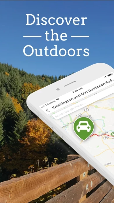
- Discover trails near you that are perfect for outdoor activities

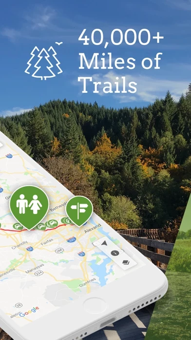
- Explore over 40,000 miles of multi-use trails in the US

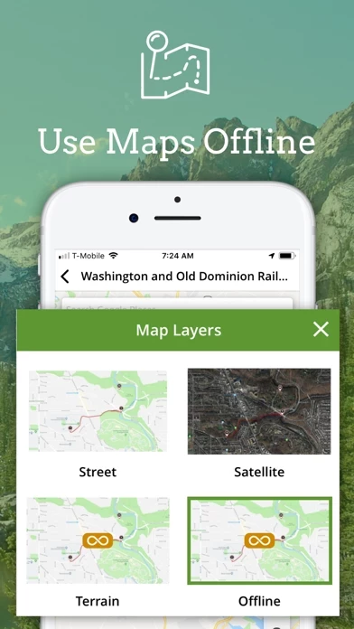
- Subscribe to TrailLink Unlimited for detailed offline trail maps and trail amenity waypoints

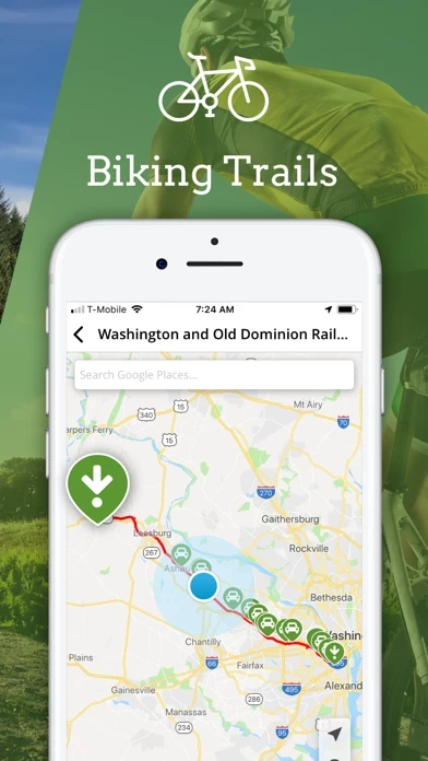
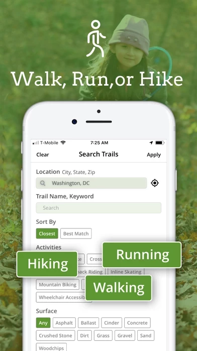
- Find walking trails with exercise stations, biking trails with great views, and more

- Empower your next on-the-trail adventures, whether you’re hiking, biking, jogging, or walking

- Search for trails near you or by location

- Download trail maps for offline use

- Read RTC's expert trail descriptions and trail reviews

- Upload trail photos and share trails with friends

- See your location on the trail and generate driving directions

- Sync your account with TrailLink's website

- Support the mission of Rails-to-Trails Conservancy

- The app offers the Unlimited subscription in the app directly through your iTunes Account for only $29.99 for 12 months of unlimited offline map downloads.


Overall User Satisfaction Rating


Negative experience
52.5%

Positive experience
47.5%

Neutral
16.6%

~ from Justuseapp.com NLP analysis of 6,342 combined software reviews.

Key Benefits of TrailLink

- Trails connect different areas and provide access to nature and historical components

- Some trails are well-maintained and have benches for rest

- Converting old train tracks into bike trails can bring life back to small towns and connect people to nature


21 TrailLink Reviews

4.6 out of 5

By


Trail terrain

It would be a great improvement to trails if areas with gravel were replaced with hard pack or short stretches of asphalt. The gravel makes it impossible for people who need to used a mobility scooter and those folks NEED to be able to access the trails too. I ride my bike and have gone from trailhead on 230 in Elizabethtown on Conewago to trail head by Southhills Park in Lebanon, the Lebanon Rail Trail. Nice that the trails connect up. Lebanon County trails are better maintained and have many benches so walkers, bikers, etc. can stop for a rest. Lancaster County needs to step it up with benches and trail maintenance for the Conewago. The entire stretch is scenic. I love going on the two trails but wish it was made more accessible for those who have special needs and use scooters. One more thing, I think electric bikes do not below on the trail. Just my opinion.


By


Better than we expected

Gorgeous with interesting historical component with commentary about Lewis and Clark journey. Close to shore and pounding waves yet accessible to a commercial area if you want to buy lunch. Some sharp blind curves with tall salt grasses that hide oncoming bikes and peds. Ideal for moderately paced, low stress rides.

We parked at Beard’s Hollow trailhead and accidentally started over the wooden bridge and up the dirt path. Steep and slippery. Ideal for MTB but not our gravel bikes. When we came back to the parking lot we chose the asphalt trail which featured a relatively flat asphalt surface through the tall grasses and pines. After riding to the end of the trail (Lewis & Clark carved tree) we rode back through Beards Hollow parking lot and cycled up to the North Head lighthouse. Great spin through a dense forest. Well designed and maintained trail.

If we lived here, we’d do this trail ALOT.


By


Ssucon Valkey Rail Trail

This trail is excellent and well maintained. My comment is in regard to one specific trail entrance - The Coopersburg Living Memorial Park is not handicapped friendly. My wife is handicapped and requires a tricycle as she lost her ability to balance a bike from Parkinson’s Disease. The entrance is filled with pot holes, road grindings (some the size of baseballs) water and mud. My road bike was fine to maneuver around these obstacles but my wife’s 66 lb tricycle just couldn’t get through without my pushing it to the trail marker. To be fair, perhaps the powers that be may not have gotten to this issue as of yet. We have found most trails to be handicapped friendly. I rarely write a review and complain but, if you’re one of many handicapped people who use these trails, I recommend you avoid this particular entrance.


By


Great Trail!

Our cycling group tried this trail for the first time this weekend. We started at the Chiefland trailhead and headed to Fanning Springs! Note: there’s no restrooms at the Fanning Springs trailhead. We then headed towards Old Town and rode to the bridge over the Suwannee River. Take the time to look out over the river and take in the beauty! Then we turned around and rode towards Trenton. Rode to the old train depot and there’s restrooms there! Yay! Then we headed back to Chiefland and rode a total of 41 miles. The trail is nice, maintained with a few bumps here and there. It was not heavily trafficked on a Friday afternoon and was a beautiful trail. We would ride this trail again. Pack water! Side note: there’s a hole in the wall bbq place right by the Fanning Springs trailheads that has great food! Get out and enjoy!


By


National Grid destruction

This was once a magnificent trail with an astonishing variety of plant and shrub species that in no way comprised the integrity of the power lines running above it and through a wetland that supported a myriad of mammals, reptiles, insects and birds. However this past winter of 2020 National Grid cut it down to the ground and all that’s left are dead sticks and stumps. They completely destroyed a thriving ecosystem. It was a crime and done against the will of the Georgetown Conservation Commission and residents who complained. Herbicides luckily have not been used and at least the wood ducks returned this spring, but it is a depressing sight. I can only hope that in time nature will endure and re-establish what was once there and that utility companies will be prevented from ever doing anything like this again, something I am working to help ensure.


By


Rapid River Trail

Hiked about 3 miles back from the trailhead. Beautiful hike, I’d call it moderate. Lots of up and down, some of the trail runs along the cliff, but my wife doesn’t like heights and she managed it just fine. The trail runs along the Little Salmon River and the river is beautiful here coming down the canyon. Lots of rapids and falls. We ran into a couple of hikers that warned us about a rattlesnake on the trail but we never saw him. I heard later that the area is known for rattlesnakes so if you take your dog you might want to keep him on a leash. We saw a mother turkey and about 5 or 6 babies. We were there on Saturday of Memorial Day weekend but it wasn’t real busy. We saw fewer than 10 hikers.


By


Trout Run Trail

Stayed in Decorah Iowa on way home to Missouri. The town is very quaint with restaurants and breweries nearby. The trail is a 11 mile loop and we enjoyed it a lot. We went both ways on the trail for extra miles and enjoyed the change of direction Countryside scenery for the most part although there is a couple miles that went by businesses and rock quarry but the trail is still well worth it. Very hilly in sections but we were on our ebikes in first assist gear and it was easy. Would have been a little challenging but doable for me on my road bike. We stayed at Hotel Winneshiek which is an old historic place and found it very nice. Stopped at Toppling Goliath Brewery for a beer and snack. Pretty cool place with big selection. Ate dinner at La Rana Bistro, also excellent. All in all a good day


By


Good info. Needs refinement.

App contains good info on trails. Once the UI is learned, navigation is fair. It's a pretty good resource for finding rail trails. I use it to find (gravel) rail trails for bike rides.

However, there are a few areas that could use improvement. First, the area map only shows trail beginnings. If you're looking at a place that's part of a trail that's hundreds of miles long, unless you know where the trail starts, you wouldn't even know there's a trail.

Additionally, some trails (like the entire east to west) are broken down into sections of sub trails, so you not only need to know where the trail starts, you need to know the start of that section according to TrailLink 's data. There needs to be a way to show the trail on the big map, not just within the trail details.

Trail info lacks elevation info. Nothing on elevation change and no elevation profile graph. Makes planning difficult. Need to have elevation graph with info, and, better yet, also a way to correspond point on graph with map and vise versa.

Finally, no native iPad app seems opportunity lost. Map exploration could use the extra screen real estate.

Good info. Good start. Good potential. Hope to see more improvement.


By


Skunk Creek Trail

Love the trail....Am somewhat concerned that fast bike riders are taking over the trail...While walking I have almost been hit from behind by bike riders that seem the trail is only built for bikes...Many slow walkers and joggers are in constant jeopardy by these fast bikes that in some cases run us off the trail...There are many families with small children enjoying the trail only to be bullied off the trail by some bikes....Their easy to identify with their tour-de-France type bikes...Something needs to be done before there are more accidents...I thought most of our streets have bike paths for these types...I guess there not content with these arrangements, and are bound to run walkers and joggers of the trail.


By


Excellent bike trail outstanding View

I have to say who ever worked on this trail they did a great job very nice trail I am so happy that it’s getting open ,For those negative people technically the trail it’s not open to the public for our safety manners we should be happy that Let us use it while they’re working this trail means a lot it’s connecting far away all the way down to the Bronx I am from Mahopac NY and I just ride the trail back-and-forth for 30 miles I can’t wait until it gets done if there is more stars I will give them more thank you so much guys for working so hard to finish our bike trail , this trail has a excellent ride nice and smooth


By


Recent Update Still Buggy

Thanks to the Developer for contacting me. I will get in touch with you later today. I’ll take screenshots of the issues I’m coming across. Catch up with you soon.
_______________

Thanks for the recent update. Initially after the recent update I had trouble logging in, couldn’t access my Favorites, I couldn’t add any new Favorites, and I couldn’t access my Downloads. As well, I would keep getting a message saying there is an error with the Format. While I am able to do the above now, there still are some bugs. For example, My Favorites show up a (0) but when I click into Favorites they are there. I still keep getting that Format error whenever I try to access anything Trail or Map related.


By


THE BEST WAY TO RECYCLE TRAIN TRACKS

I am not always sure getting rid of trains for transportation of goods/products was a good idea. Especially when one considers all the man power it took to lay them. Let alone all the tractor trailers now on our highways due to their closings. There is no better way to reuse them in my opinion then to convert them for bike riding and walking. It connects us humans to nature and each other. In some cases it’s bringing small towns, that were left behind during the rails decline, back to life. All while preserving our national heritage of the folks that built these great tracks. Where’s your bike taking you next?


By


Love the app but have one suggestion

I love TrailLink. We just got into biking this year and have enjoyed trying out new routes. I prefer biking on trails more than roads and have downloaded a dozen maps so far. They are very useful since most trials don’t have adequate signage and therefore we can use gps with TrailLink .

My only complaint is this. We prefer to ride a minimum of 20 miles at a time. If I see a trail that is only 3 miles long I will skip it. Not worth the drive. But I’ve realized that a lot of these continue where another trail ended. It’s really hard to see this on TrailLink . Would be nice to have a filter on TrailLink that would show all the trails in an area.

All in all I love TrailLink. Can’t wait to go out and explore more trails.


By


One of our Favorites

We have been riding our hybrids on the CVT for several years. It is our “go to trail” on hot days because of long stretches of wooded areas.
Recommend starting at any of the southern access points which begin in Watkins Glen. Then ride north toward Horseheads. Each of the access
areas has adequate parking.
From Montour Falls to Millport it is slightly and consistently inclined. It has beautiful woodland views with wildflowers that change throughout the seasons. On the return northern ride it will be all downhill with a wonderful breeze.
There is very light bike and pedestrian traffic which is appreciated during this summer of Covid.


By


Wonderful hike

We did this hike while my daughter was attending you pen. It was fabulous and we did it in the early fall before the leaves came down. I would love to see it again at one of the seasons when leaves are down or in the complete fool with all the colors. This is well worth the walk. It would be better now because when we went we had an uphill 1.5 mile hike to get a bus back to Germantown. Now with Uber‘s active it should be a lot easier.
I would encourage anyone to do this hike it’s absolutely stupendous. Can’t wait to drag my best friend down here and walk it again.


By


First time user > forever user

My boyfriend & I took our dog on this hike. It was so much fun. Make sure that you follow the signs because there are so many different trails intertwining throughout the hike. Using the map is ideal in a few places but mostly, just follow the signs. It was an amazing day hike, however; I’d recommend going earlier during the day because we got to the end of the trial & it was sunset. The most beautiful sunset view I’ve seen in a while. We walked back through the neighborhood because it was dark, that was also beautiful & very well lit. We will definitely be back.


By


Always beautiful.

I rode this trail once again, 8/6/21, and it did not disappoint.
Since I rode it last, from Rupert to Granville, it has been resurfaced with crushed rock. It is consistent, and allows for a wider pathway than the former surface, two narrow ruts between a center gas’s strip.
I wouldn’t recommend a skinny tire bike, but my hybrid with wider tires was a comfortable ride.
The diverse scenery- swamp with birds and cattails, pastures with cut hay, old factories slowly settling into oblivion, lots of running water next to the trail - always captivates me. I find this southern portion of the D&H is a very special, quiet, remote place. Always beautiful, whatever the season.


By


Disappointed

Full of annoyances and problems. Big icons cover and obscure map, very poor map navigation, oversimplified trail maps, very few (and confusing) display options, repeated annoying pop up, always resets to Washington DC, rife with outdated info, iPad version displays only portrait view, Trails Near Me shows trails hundreds of miles away in other states. Local governments do such a poor job of their own trail web sites that it leaves the door open for poor apps like this. While TrailLink is not a complete waste of time, I’ll be on the lookout for a better app for sure! NEXT DAY RESPONSE FROM THE DEVELOPER states their opinion that my review is “overly critical”! Wow, not only a very poor site, but a very, very testy developer! I certainly don’t expect improvement after such a smug response! (Adjusted rating down to one star.)


By


Trail link app

I ordered the Florida map and then loaded TrailLink while I’m waiting for the paper map ( I love paper maps) and found TrailLink to be super cool easy to use and has a ton of biker useful features. To unlock all the features you have to spend a little cash but even if you don’t do that you have access to all the maps. Becoming a member and getting access to the full features allows you to save the trails, comment add pics etc. Plus have off line access to the maps. I will most likely subscribe for this as well.


By


5 Miles on Homestead “Express” Trail

I only rode this 5 miles from the TH by the bar “The Rail,” but it was very pleasant. The trail starts being paved but turns to limestone approximately 1 mile. There were turkeys and babies within that one mile, which is partially shaded. The trail outside of Beatrice is well shaded for the first couple of miles. This makes for a cool breeze while hammering the pedals. You’ll cross four wooden bridges in those 5 miles, tracing Indian Creek part of the ways. I even spotted a fawn drinking from the creek.
The only down side was the brush sticks out too far when crossing the roads. The city need to trim it. I highly recommend surfing Homestead “Express” Trail for a reconnection with nature and a blast into Gage County history!!


By


Newest Update resolves previous issues

I love this app. It is my go to resource for finding new trails in new locations. TrailLink allows me to find suitable trails for my road bike, and then helps me easily navigate to them. The maps, trail info, and reviews are extremely valuable to me.

It will still take me a little more time to get used to the new UI, but the developer seems to have fixed the problems I previously had. Thanks, this app, for reaching out to me and working to make TrailLink awesome again.

******** previous review: Most of my favorite functionality is gone in the new update. I hate that I can no longer “redo search in this area” to search for trails in the area I have showing on the map. I am a truck driver and pretty much search for new trails every day, depending on where I happen to be that day.

The search location screen is disastrous. If I try to tap one of the autofill suggestions, entirely different cities and states are filled in. I also hate that I can no longer just scroll around the map and see all the trails in the country.

I know, with new updates it takes a while to get the wrinkles ironed out. I have faith the developers will fix these problems. Hopefully soon, as this is one of my most often used apps! *******end of previous review


By


Challenging trail

I love OCA! But it’s not a walk in the park and if you are looking for a cardio training path you might be disappointed with the stops and starts. The terrain can be rough with rocks and roots and erosion damage especially after heavy rain. Thicker tires are necessary. Certain spots also have a lot of pedestrian traffic and they are often oblivious to their surroundings with earbuds drowning out your approach warnings. I’ve had people wander right in front of my path even as I’m shouting “on your left!!”

It is beautiful, though! Lots of deer and other critters watch silently as you pedal past.


By


Update

The new update is too buggy. You search a place for location it pops up so you click it and another place (not even listed) shows up???

Update: new release seems to have fixed the problem


By


Good Resource

Since I travel a lot, I find TrailLink useful for zeroing in on trails that I can enjoy while in new places. TrailLink saves me time by providing local information & helpful hints to maximize my experience. Thanks!!

Also, I cannot understand how anybody could ever complain about paying a bit for work that others do, to make your life more enjoyable. Seriously, TrailLink creator/manager seems to be communicative w users & wants to improve TrailLink ongoing.


By


Waste of time and money

At this moment, if I could give it no star, I would. Download TrailLink , was using it as well as the website on a regular computer, found them both rather clumsy to use but was able to pick out a few potential trails. I realize that to be able to download them for off-line use, I would need to make a purchase of the unlimited version which I did. When a couple of days later it came time to need to use TrailLink on the trail, I could not login with my same credentials, could not reset the password, could not access my favorites and certainly not the downloaded maps that I spent some time on. Beyond frustrating.


By


Please make an iPad native version...

The iPad version is simply a scaled up version of the iPhone version. Very annoying. I tried to write a review for the extension of the Bruce Freeman Rail Trail in Acton, MA, and I was limited to about 3 lines of text without a scrolling capability. I was unable to complete my review because I could not see what I was typing. Too bad, because I was attempting to post a 5 star rating for the trail but TrailLink let me down. TrailLink also only works in portrait mode 😕 which is VERY annoying. Perhaps these issues are why I had removed TrailLink from my iPad (I needed to re-download TrailLink to post a review). Please fix it!


By


Much easier to travel.

When I took a trip to Maine three months ago to ride the rail trails I didn’t have this app Unlimited. I did not print out the trail info and maps that I needed in order to navigate effectively. As a result I rode one of the trails all day thinking it was 28 miles in length when really it was 38. All the pedaling aggravated my knee and I was nearly exhausted. I never wanted this to happen again. Now that I have this app Unlimited I have no real fear of a mishap.


By


Hidden gem:)

Absolutely loved this trail. I ended up running the trail while most ppl were biking. Both are easily done! The trail has crushed rocks but mainly level. The views are breathtaking and make you forget where you are with the turns and bends on the path. The trees provide great shade for most of it. I parked at the outlets and managed to get a 6.0 mile run (turned around about a half mile into the neighborhood the trail opens up into).
Enjoy!!


By


Love this site/app

When I travel I like to know where there are trails in the areas I will be in. this app outdoor maps help me find trails that suit my desired distance and surface depending on what I will use them for. It is nice that there are photos posted from other users that even help out even more since I can see what I will get to see on my journey!! Love TrailLink and have used it for years.


By


A Bike Riders Must-have Tool

I have used this app website and app for a number of years. (I have an annual subscription.) I have used this app to find greenways rail trails. It’s a valuable resource that I have used to find and ride trail in Georgia, South Carolina, Tennessee, North Carolina, Mississippi and Florida. The trail descriptions and very useful. Downloading the trail brochures are also a great reference for parking, trailheads and relief breaks.

Yes it is very appropriate to say, “Try it you’ll like it.”


By


Horrible App

While in a mountain range that has a plethora of hiking, camping, ATVs, etc. I just downloaded TrailLink for peoples reviews of the options around here and if they had any tips on where to park and what trails allowed dogs.. well, I downloaded TrailLink, put in my location and absolutely none of the local hiking anything popped up.. if I hadn’t already hiked in the area I’d have been completely steered in the wrong direction and finding myself driving BACK DOWN THE MOUNTAIN to go hiking... that doesn’t even make sense. I immediately deleted TrailLink. A complete waste of space on your phone; find another app.


By


Horrible for ATV trails

Googled “ATV trails near me”. This website/app was one of the first to pop up. So, I downloaded TrailLink , signed up and when I search for ATV trails, it says no results found. I’ve tried every city I know has ATV trails and my current location. Even tried leaving the location blank. Also, there is a completely different tab to search for trails. You can’t just refine what’s showing on your map. Deleted almost as quickly as I downloaded. Seems to have plenty of mountain biking trails so that probably works just fine but that’s not the reason I downloaded it.


By


Greed

I have to pay for each individual trail map, but there are other apps that offer the same service for free, or just an initial app purchase, also without having to deal with logging in. No thanks, deleted.

Edit: To the developer response; If that's the case then just charge initially for TrailLink purchase, I would be more than happy to do that. But this is freemium BS and it's deceptive. And why in the world do I need a freaking login for a TRAIL APP. This trend of creating an account for everything is tired and unnecessary. This is why I deleted your app and gave it one star.


By


Useful app with easy UX

Downloaded TrailLink while on vacation to find some good running trails. The map and search functions are great. I like that I can favorite trails for later and the community reviews are helpful. I wish you could download more than one map for free, but I get it. It is a service that should ultimately be paid for.


Korjagin Susan   2 years ago


How do you stay logged in? Each time I open the app I have to renter my username and password.


Is TrailLink Safe?


Yes. TrailLink: Bike, Run, Walk is very safe to use. This is based on our NLP (Natural language processing) analysis of over 6,342 User Reviews sourced from the Appstore and the appstore cumulative rating of 4.6/5 . Justuseapp Safety Score for TrailLink Is 47.5/100.


Is TrailLink Legit?


Yes. TrailLink: Bike, Run, Walk is a totally legit app. This conclusion was arrived at by running over 6,342 TrailLink: Bike, Run, Walk User Reviews through our NLP machine learning process to determine if users believe the app is legitimate or not. Based on this, Justuseapp Legitimacy Score for TrailLink Is 64.1/100..


Is TrailLink: Bike, Run, Walk not working?


TrailLink: Bike, Run, Walk works most of the time. If it is not working for you, we recommend you excersise some patience and retry later or Contact Support.


Pricing Information

**Pricing data is based on average subscription prices reported by Justuseapp.com users..

TrailLink Unlimited

- Price: $29.99 for 12 months of unlimited offline map downloads

- Features:

- Detailed offline trail maps

- Tens of thousands of trail amenity waypoints

- Search Google Places for easy access to trail-side businesses

- Ability to cancel subscription at any time and manage it in Account Settings.


How was your experience with TrailLink: Bike, Run, Walk? Post a Review

Leave a comment:


Alternatives