🏷️ About:
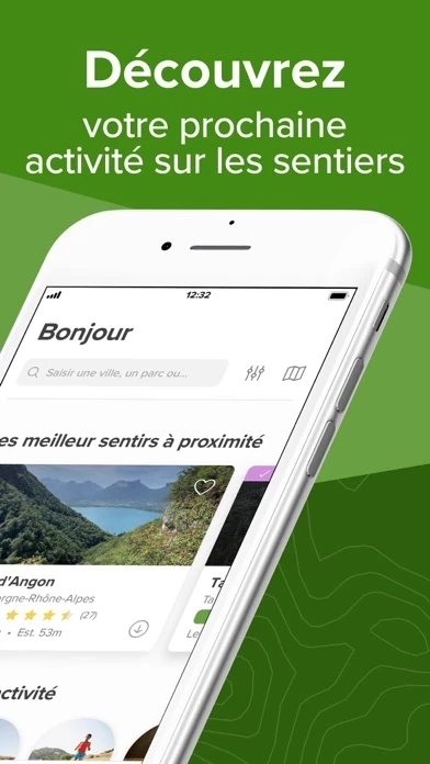
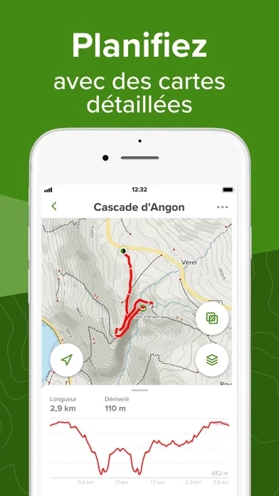
AllTrails is an app that helps users discover the best hiking, running, and biking trails around the world. It offers hand-curated trail maps, reviews, and photos crowdsourced from millions of hikers, mountain bikers, and trail runners. Users can find dog-friendly or kid-friendly trails, record their adventures, save their favorite trails, and get detailed GPS driving directions directly to the trailhead. AllTrails Pro is also available as an annual subscription, offering additional features such as offline maps, off-route notifications, and real-time map overlays.
- Provides reviews and recordings from real people
- Keeps someone in the know of user's whereabouts
Read 33 Customer Service Reviews 👿🤬😡😠💢😤
4.9 out of 5
Not happy ending!
2022-05-22
by Aramiamo
I have been using this app for quite a while, let me makes this clear, this was my 5 star app to go with all the time! And still is, BUT! There was an issue popping up on my app, I tried to figure it out myself, didn’t work. Then reached out to the support, they told me there was no issue and everything looked great on their side! (Felt like they were blaming me) so after too many back and forth emails finally we decided to screen record the steps I was taking on AllTrails from beginning to the end (because they thought that was me rather than AllTrails ), they finally believed me and accepted there was an issue! Phew! They wanted me to delete AllTrails (actually I was the one who asked them if I should) and they were like: oh yeah! You have not done that yet??? So I did, and dowloaded it again, it temporarily fixed the issue! But deleted some of my saved hikes and folders, and duplicated some others at least 20-30 times, but all empty! Then I thought that was my phone being old and glitchy (iPhone 8 plus, with no technical or any other issues) so I switched to iPhone 13 pro Max! Guess what, that issue still accruing ! Oh and I am a PRO subscriber as well… so now I dont know where to get help from. Apparently this app has only one person who is responding to these kind of issues, and I think we are done!
Love the features. Old UI was iffy. New UI is bad.
2022-06-23
by Euphorbia Monstrose
I am a generally happy all rails pro subscriber - it’s made my COVID-inspired outdoorsiness possible! But the new UI is ...oh, not good. I loved the simple Record button. Now when I manage to find the button through Navigate (which is not the right word! I’m not navigating, just starting to walk from wherever I am and want AllTrails to capture it), and press Pause, doesn’t leave it paused. .The old version often stopped my recording when I only wanted to pause - and I couldn’t get back in and tell it Nope, so I would end up with two hikes split up because I couldn’t opt to continue where I left off. But,the new design is worse, because not only is it completely unintuitive to even find the button to start a recording, now if you don’t press and *hold* to stop/save, and simply hit pause (perhaps because you don’t care if you save the recording), it just seems to keep recording. So I wound up with a ~80mi hike the other day because it captured my entire drive for the day after I had thought I stopped the recording, and the walk itself was maybe half a mile. So now I had to delete the entire hike, which is not a huge deal but now my iPhone health app thinks I was some kind of superwoman for a single day and will forever compare me to it, unfavorably. I love AllTrails. But please get some more experienced ux folks to review these designs.
Maps on watch need improvements
2022-07-24
by Leftquark
The this app iPhone all is pretty much a 5-star app. My biggest gripe is probably the long load times to lunch AllTrails . I have the latest version which was supposed to improve app launch times but instead I’m seeing some of the slowest launches to date. Today I paused a recording to take some photos and when I came back to AllTrails it took nearly 30 seconds on an iPhone 11 Pro Max. Considering AllTrails was open and running 10 seconds earlier, with a recording paused, I would have expected AllTrails to launch instantaneously. Please fix this, especially when re-launching a paused recording.
But my ultimate 3 star review is for the watch app. I love that I can finally see the map on my wrist without having to pull out my phone, but then to shrink the map so small with superfluous information below it, makes the map nearly useless. The watch screen is so small as it is, so having the map shrink to a small square means I can barely see any detail in what’s coming up in the trail. I like that I can select what information is displayed below the map, but I want a “none” option so I can see the map as large as possible!
Otherwise I love AllTrails - mostly because it has a bazillion high quality maps and I can easily search and find a trail to hike!
Will be looking for another app...
2022-08-25
by SnowMonkey28
Overall AllTrails is great! Easy to use, helpful to find new trails, pretty great tracking and mapping. The only complaint I have, and it is a deal breaker for me, the save and clear buttons are right next to the record button. When you pause, and then go to start again there is a chance you’ll end your current ride, walk, etc. Terrible placement for those. It is common we will ride, and at some point pause for water, session, snack, and then the save button is accidentally hit or even sweat falling on the phone has cleared a current ride. It’s insanely frustrating when you want the recorded 10-15 mile path for reference or whatever and it is cleared from accidentally hitting save. I feel like that is a really terrible issue to even have to worry about. Even having a “You sure?” after selecting save would be great; then you could back out of it. Started looking into other apps to use and found I really enjoy Strava. Great community with that app. I recommend checking it out and using it.
The clear button does have a “You sure?”, but save doesn’t. I like that someone reached out to me about the issue, and again, AllTrails is great overall. Although I responded, there was never a response from them.
My overall impressions of AllTrails have been good, however, since the most recent update, there seems to be a glitch with automatic syncing. I use my Garmin watch to track activity and it is automatically synced to this app. this app is consistently adding an extra mile to each hike from what is tracked in Garmin. If Garmin Connect tells me I’ve hiked 8 miles, this app lists it as 9 miles. This has only been an issue since the new update; everything matched prior. This has been incredibly annoying since the mileage is not accurate. I’ve been uploading the GPX files but also new, this app is not recognizing the time and pace info (even though I’ve previously uploaded GPX files with that info). I contacted this app but they didn’t have much have an answer. Rep mentioned this app uses “smoothing” but it doesn’t make sense that “smoothing” would add distance. Is anyone else having this issue? Hope it gets fixed, but it makes me less inclined to use this app to track hikes.
Update: this app “addressed” my issue but ended up completely missing the point. They wrote that our phones have “noise” but my issue is this app is incorrectly and randomly adds distance to my Garmin synced files. Why would they add distance to a synced file? That seems to be an issue with their app specifically.
Great app with one major flaw
2022-10-27
by EvoRacer37
I’ve been using this app for a couple months now and I love it. It is a 5 star app by far, yet that is not my rating for it. There are a few quirks I have with the UI, but they are not worth mentioning as they are minor and do not effect AllTrails use whatsoever. My only real issue, which caused my 4 star rating (which killed me to do so), is the fact that you CANNOT LAUNCH AllTrails WITHOUT A CELLULAR OR WIFI CONNECTION!! It is ridiculous, plain and simple. I am a Pro subscriber to this app. I did this solely so I could download trail maps prior to going in case I lost service on the trail. That feature works beautifully. But let’s say you download your map, head out to your trail, arrive and go to open app to use the map that is already saved on your phone. Guess what?? Unless you have service, you can’t open AllTrails ! So it’s essentially useless. The last thing I want to do is have to add “open this app prior to leaving home” to my to do list to get ready. this app, lets be real for a minute. Hiking, biking, exploring, etc. are all off the grid things! Chances are you won’t have service if you are in a remote location. Fix this issue!! Make an offline version of your app so that paid users who have already downloaded maps can actually use them! With that said, this is an amazing app that is worthy of 5 stars. It is just failing miserably in one particular area that is critical to its use.
Good app, but ...
2022-11-28
by Mt_shasta_hiker
I have been using AllTrails for hiking and mountain biking. It´s very valuable and makes you feel really confident and worry free, that you are following the right trail and that you will get home safely. Although, I have found 2 things, which need improvement : 1) I was recording my day hike and when I got back to my car, I wanted to save the hike, review it etc. But, there was no cell phone signal, which typically there isn’t, when you hike, so the application wouldn’t let me finish the process of saving/reviewing/adding comments. Then I drove back to town and wanted to finish this process. But the application, was basically asking me, if I want to continue recording, if I said “no”, the only choice it gave me, was to clear the data. Of course, I don’t want to add car drive to my hiking trip ...., 2) The other improvement is related to it. I think, if one is recording hiking trip and then forgets to save it, when gets back to car, the application should automatically detect, that obviously one is not hiking anymore, since the speed is > 10 miles/hour. It should then, ideally, ask you, if you want to make the car ride part of your recording or not. Actually, this happens to me a lot, that I forget to stop recording or that I’m not able to save the trip, because of missing cell phone signal.
Moderate Hikerbiker
2022-12-29
by HungryEater0329
The trail suggestions and information are very good and useful. I use AllTrails for both casual biking and hiking. (As it’s advertised for both. Some suggestions. 1) Would be nice for the recorded route tracing to be a heat map showing pace along the way. Note, this also helps determine direction in intersecting and overlapping lines in a route. This is especially useful for biking and running. It would also to have heat mapped pace to be recorded on elevation diagram to see where I can use improvement. (How I’ve improved on uphill portions of routes, for instance). 2) I just went on a 1:18 route on my bike, recording and using the map for directions. iPhone X went from 90% power to 17% power. Another app I use for the same purpose has WAY LESS battery consumption. I would really like to use the Pro version of All Trails for biking, but this level of battery consumption will be prohibitive. 3) Would be great to have hike/walk, run, bike settings for All Trails. While most of the settings would be the same, I might not need always on map for running or hiking, and sampling rate may be different. 4) Integration with FitBit and/or Apple Watch.
Get the Details, Hike with Confidence!
2023-01-30
by RoseCityCat
This beats a trail book for excellent topo maps. The recent user trail comments are incredibly helpful for understanding current trail conditions. Love the posted photos so you can get an idea of views you will encounter. I love the fact that Printed maps show an elevation guide. Very cool that you can view a trail, and then see “nearby trails” allowing you to quickly assess what’s available in a given area. The reason for 4 stars is that the program needs several improvements 1) the trail creation features are not simple to access and use and can snap onto the wrong segment and can be problematic to close on loop trails for accurate distance measurement. 2) maps only print at specific ratios (not perfectly zoom customizable) so often trail is printed too small or large. I often have to split trail into 2-3 pages to get good detail. 3) the chosen route prints as a continuous red line and covers up the forest service trail numbers... forcing you to hand label printed maps with the #s if you are linking trails etc. Those deficiencies aside, this app is an amazing tool to plan. It’s given me the confidence to discover and hike trails I would have never attempted otherwise. App is nice for downloaded trail map. GPS point can help confirm current location which is reassuring!
Been a loyal user for many years and recently upgraded to pro. There’s a lot to like about AllTrails, albeit a little confusing at times. However, one thing that absolutely must be fixed, is the recently introduced app crash while navigating (or recording your route). Just spent three days/2 nights out on trail and the navigation crashed every bit of 4 times each day. We missed miles upon miles of recording because it would crash while in my pocket. Read a few other reviews where customer support told them to fix by making sure All Trails was the only thing running on their phone. I’m here to say I tried this and it continued to crash (also, that it’s a bit ridiculous that this be the explanation, considering Google maps and Waze can handle constant navigation for prolonged periods with multiple other apps open). It’s a huge miss if your trail navigation app can’t reliably navigate you on the trail.
Also, the watch app is utterly useless and has never been reliable. Although, this is merely a nice-to-have, not a need.
MUST HAVE APP!
2023-04-01
by OriginalRedlayce
I absolutely LOVE AllTrails!! I hike alone 90% of the time and I love this for finding new trails, staying in trail and keeping someone in the know of my whereabouts. I love the pictures, reviews and recordings submitted by real people so I can understand whether it’s something I think I could handle or not. The only downsides I’ve come across so far are 1) when you’re flipping through submitted photos, you can tap in the white area near the persons name who submitted it in order to see how long ago it was (ie a month, week, year etc) BUT! Be careful!! I’ve accidentally hit “suggest hide” on a couple photos and you can’t undo that!!!! Super frustrating!!! I’m not trying to flag or hide anyone’s photos! I just wanna know when it was taken. I’m sorry people! 2) when you’re looking for trails in your area using the map, you have to zoom in/out to the perfect spot for the trail markers to pop up. They disappear really easily if you zoom in or out too much in the slightest or if you move the map position even a tiny bit. I feel like those are both easy fixes. I recommend any outdoorsy people download AllTrails . It’s fun to pick hikes for each other when you live states away and then chat about them after you’ve completed them! I love AllTrails!
Above and beyond
2023-05-03
by Pocket Frogzzz!!!!!!! :D
I’ve been using AllTrails for a short amount of time and I love it! Trying to google hiking trails only brings up 2 or 3 around my city that are usually overcrowded and not that great, but AllTrails has over 100 listed in my little town. It has everything that I could ask for and more—filters to search certain trails (bike route, allows dogs, waterfall/rivers, etc), difficulty ratings, weather forecast, reviews, photos, trail length, personal stats, and more. Some of these trails are in the middle of nowhere and you can pull up directions to drive to the start. It tracks your time, elevation gain, miles, and your route. You can save your favorite trails, and the ones that you have completed will show up on your profile. I haven’t been hiking a whole lot in the past, but now I have been going several times a week and I still have a lot of trails saved that I want to try! It’s like a social media app for hikers. If you like to hike (or if you think you want to start), I would recommend downloading AllTrails. It exceeds my expectations and I have never been so motivated to go out and explore!
AllTrails saved me a rescue.
2023-06-03
by Stephb11188
A couple years back I took on an ambitious 13 mile day hike by myself on beautiful sunny day in the Colorado Rockies. While I was familiar with the area, I had never done this specific route before. I had not brought a compass or my SpotX (dumb move) so I had this app pulled up running in the background of my phone so I could refer to the GPS on the map. I had made it over the mountain pass and was making my way down the other side back down to treeline to discover the trail had been washed out. I didn’t think anything of it and started following the creek thinking it ‘ah it’s probably just down here.’ I walked about a half mile before I realized I wasn’t in the right place. I got completely turned around and had no idea which way led back up to where I came from and I had zero cell service. After a brief moment of panic, I remembered I had this app was running so I pulled out my phone and slowly but surely followed the little blue dot as I moved through the woods. According to the map, it was close but I still couldn’t see it. After about 15 minutes, I heard voices and saw people walking above me. I had found the trail! I bushwacked up, took a deep breath and continued on my way.
Thanks to this app, I manage to right my path and get back to where I need to be. While it’s not accurate 100% of the time, it truly is a great resource.
Excellent App Useful for Horseback Riding
2023-07-05
by Horsinjohn
I use AllTrails as an adjunct to Horse Rider for horseback riding. Checked it out on a 9.5 mile horseback ride at Lizzie Lake near St. Cloud, FL. One other rider has AllTrails also. At the northern end of this trail is a series of relatively short loops that would be easy to get mixed up in. AllTrails worked perfectly for the main trail and all the little loops. The big plus for my usage is that it shows your position on an this app map. It seems to be accurate. However, in some local trails that I frequently ride, I have seen some instances where the this app map is not quite up to date. However it does show paths that people actually use, which are not always the same as the park or reserve on line maps. I use Horse Rider to record my track, which includes the path, speed, and in my case heartbeat, calories, distance, etc. The great thing about Horse Rider is that it automatically shows your path on a satellite map. These make a great pair, as you can instantly check your position on the this app app without scrolling through a lot of stuff. Local to the places I ride, the maps are generally complete and accurate.
I love AllTrails and have been using it for years now. It is by far the best GPS tracking app I can find. The maps are detailed and accurate and the descriptions and directions are excellent. Over the years some great upgrades have been made, some of my favorites include being able to download tracks for offline use, marking distance and elevation along a specific track, and being able to create a map by selecting certain trails.
There are still some frustrating faults with AllTrails, however. For example, in order to record and keep a GPS recording a track a hike has to be part of an existing trail which can get annoying when I do infrequent or bushwhacking hikes. Having an option to keep tracks privately would be very helpful.
One upgrade I would love to see is the ability to edit or add to a track after I finish. Many times in the past I have forgotten to end a track and drove away, the result was an inaccurate GPS track. Also as AllTrails currently is I can’t track multi-day trips, I can pause a track when I stop for lunch, but if I stop for the night my progress disappears. I would like to be able to add to a completed or paused track to be able to record multiple day trips.
My go to app for outdoor adventures
2023-09-06
by Vtdogguy
I’ve had all trails pro for over a year and planned several hikes on it and tracked them. I have not found any other app with as many trails or as complete. I absolutely love the ability to download various maps prior to my trips because they are usually in areas without cell service. No where else has all the types in one place or as easy to find. The tracking on the downloaded maps has saved me and my son’s Boy Scout troop miles in areas where it gets more difficult to stay on trail. In addition to hiking (day and multi day) I like to take my truck out on trails and the reviews here have been great on helping to decide where to go .....and not.
All that great stuff said there are a couple things I’d like to see. First would be the ability to plan hikes on my IPad or phone. On the same vein the ability to see and update my account on iPad and phone. The biggest things I would like to see is the location of springs/ water sources with icons maybe 2 icons 1 for drinkable and one for filtering and maybe something to indicate if it’s conditions depending or always there. Also an icon for camp site locations. These would make planning longer multi day hikes easier.
Never Ending Trails
2023-10-08
by Mopfdt
I love it! I’ve moved to a new town about a year ago and I’ve only ever known my town hiking spots. So to move somewhere new and not know anywhere to go was frustrating! I love bringing my dogs hiking and even better to find spots they can swim or frolick in the water. BUT once I go somewhere I feel accomplished and ready for the next. So to find so many varieties and close by places to hike is amazing! Whatever town I’m in I just look up what’s around. Whenever I’d Google placed to go there was NOTHING. Or very short and disappointing places. AllTrails is great because it will give you direction right in AllTrails instead of trying to Google Maps it yourself. You can map your rout and GPS where you are to ensure you stay on track and don’t get lost. I’m so much more comfortable going alone when I can see where each path leads and about how long it should take me. People also are great at providing pictures and comments of the trails so it is so easy to find. My biggest annoyance is not being able to find the place to begin with! GPS is all good and dandy but sometimes it will just bring you to the location but the location isn’t clarified. So by people uploading their photos let’s you get a visual of what you’re looking for. Overall, the best app!
Crashing on Course
2023-11-08
by Spencer99Jones
Hello! Pro member here and have some concerns. AllTrails keeps crashing while I’m in the middle of 20-30 mile hikes. This is dangerous when you rely on this app to alert you when you’re off course and have a lifeline feature engaged so your husband can track your progress from work! I am also frustrated because when it crashes, it also leaves me with gaps in my recordings till I figure out that it’s not working. I prefer to be enjoying the surroundings and not constantly checking if AllTrails is recording and connected. I have been a Pro member over a year and have had no major issues till recently. Just sent an email to this app about this concern. Thought maybe leaving a review would get a quicker response. A few notes to eliminate user error when the crashes occur - My phone battery has plenty of charge. No other apps are open on my phone. It literally has an error message that something went wrong. this app please help! Please fix! Also, I’m discovering that some of the maps underestimate mileage up to a few miles. Have been planning on those underestimates because they’re unreliable when planning how much daylight a hike may require and the quantity of supplies to bring.
Few issues lately. Oct 2018
2023-12-10
by DaniG1973*
Removing the check-in was a bad idea. Hiding it in the “...” was worse, didn’t know it was there and my history is now not accurate, and now I have to make up a name for each recording on the fly. Waste of time. Please put check-in back where it belongs, it’s a critical feature, and right map loads with the name of the trail on the saved history. I also agree with the other user about trail hopping. In New England many trails connect but are listed separately. If you are no longer on the same one you started it appears you are just going rogue on the map. How about auto loading the newly entered trail? Also being able to edit history would be helpful. There’s been a couple times where I started driving home and forgot to hit pause and save. And why the “pause” button when the trail is complete? It’s a weird way to “finish” or “end hike”. Big issue with crashing during use lately. Thought I was recording and it had crashed once phone was put away. If I didn’t stop to take a pic early i would have gone pretty far without noticing. Stinks for tracking distance 😐. Overall I do love and use and recommend AllTrails almost daily to find trails and track my history. Can’t live without it but its been acting weird lately.
I absolutely love AllTrails. It really does show you trails that you cannot find online. Sometimes the map is a little bit off where you need to park but other than that it’s absolutely amazing. If you get the paid version it’s even better. It will track you where you are and it’ll send an alert to whoever is on your list of contacts that you approved to show where you are and if you take too long it will give that person alert and where you are. I really like this feature because sometimes you never know what will happen and it could save your life. On the paid version it even let you download the map so even if your phone goes out of service you can still follow yourself and make sure you’re on the path. If you are reading this and you are the creator of AllTrails I have a suggestion maybe put in an area where people can put if there’s a bathroom or not at the beginning and if it’s a porta potty or regular bathroom. Some people are nervous right before they go hiking and it’s always nice to know. But other than that your app is absolutely amazing and I do suggest it to everyone that hikes near me
Buyer Beware
2024-11-18
by Emilypcut17
I bought AllTrails a couple of days ago and tried to use it for a backpacking trip in a nearby national forest. Firstly, AllTrails ’s maps didn’t match the park’s trail maps AT ALL, so I decided to take both with me of course. As I went on, it seemed like the this app version was just random gps points that had been made up. We were somewhat in the general area but absolutely could not have used it to find our way anywhere out there. I tried it again on another trail when we got back just to see and it wasn’t accurate either! Most of them have been, but if even some of them aren’t, then I cannot trust it. I planned to use this product for multi-day trips but it seems super unsafe now. The worst part is, when I went to request a refund for the above reasons, I got immediate denied (without anyone even looking into my claim) and it’s near impossible to get ahold of anyone at this app. So, that’s $60 that I’ll never see again for a product that I’ll certainly never use. I do not recommend this product! The free version for simple day hikes was great. But if you want it for anything more in depth, this is not the right app for you!
Good phone app with a garbage watch app
2024-11-18
by Kernal_Pan1c
AllTrails itself is the best I’ve found so far at finding trails. This probably because of the wider user support compared to other apps. It does hit your battery a smidge harder than other hiking apps I’ve tried but so far I haven’t had that be a real problem. However, I cannot for the life of me understand the thought behind the watch app design. All you can do is start/stop a recording and then check some basic stats. No map integration for you to quickly check and see what way you should go at the fork in the trail, which seems to me to be most of the reason you’d want this on your wrist. Most of the other options on AllTrails store offer this. Also, still no health integration? Not vital but cmon it’d be nice.
Overall I recommend it for finding popular trails and helping you get along while hiking as they’ve got pretty good user support. But man, it’s not updated very often and when new features are added they’re not very well thought out. I’m coming up on the time where I need to renew pro and I’m not sure I will. I might just use google to find the trails and use another more well thought out and feature rich app for the hiking itself.
It has a few good qualities
2024-11-18
by Jfdexghffsgvhfdd
I like AllTrails, it helps me with planning my hikes. There are a fair amount of accuracy issues though that keep me from considering upgrading to Pro though. First is the fact that there are a fair amount of trails that are well out of date. From what I understand users can suggest edits, but only through the website on a computer. I personally am rarely on my computer so am unable to submit the edits, and I feel this is against good trail management practices because it encourages people to use trails that are closed to prevent erosion and overuse. In addition the trail names on the map are more often than not completely different from official trail names so in the event of an emergency that could cause some issues.
My second issue is there is no way that I can find to flag inappropriate comments on a trail review. Saying a trail has been “ ruined by Mexican trash and their families” should be able to be flagged for deletion.
Lastly for now, I don’t like how you can pick only one trail when you record. I trail hop frequently and just one trail option isn’t very suitable for me and in the community aspect it isn’t helpful with helping others plan their hikes.
Free version is good wasn’t impressed with PRO at all
2024-11-18
by Jsmzm
I would give the free version 5 stars but the paid version 2-3. The free version allows me to see the maps I need and the standard trail when I’m within service areas or no signal just fine. I’ve used the free version for over 10-15 long hikes outside of cellphone service areas. I purchased the pro access today before an attempted long hike and it made absolutely no difference when I was in the middle of trying to hike a trail at 11,000 ft altitude snowshoeing through snowed over trails with way over 5 feet of snow. My main objective was accessing the topography maps and weather overlays. I downloaded the maps before hitting the trail, but once I was I was on the trail I didn’t have access to them since there was no signal. I got the same features as I did with the free version so I was somewhat disappointed. AllTrails also constantly resets so you have to bring up the map several times which isn’t ideal if you out hiking trying to make sure you stay on track, while also looking out for wildlife.
I have used AllTrails for a couple of years now with the pro version. In the beginning it might have had issues but I think they are tied to performance issues of the phone and the network and satellite hardware. I have been to many trails and it has worked great. This new lifeline feature is going to be great especially for my wife since I usually hike alone. It has helped me get back on the trail in areas where the trail is poorly marked or no real markings at all like out in West Texas.
I took a turn off a trail ( not on purpose) thinking that was the trail. It was the most dangerous turn possible. I finally sat down and pulled out my phone and looked at my all trails plot. I was way off but too dangerous to back track. So I plotted a way across the steep mountain side to reconnect to the actual trail.
On thing that would be nice is if would tell me when I have diverged from the trail with a voice warning kinda like google maps or tell me I’m at an intersection and take the left turn again via a voice notification.
A helpful friend into unknown territory
2024-11-18
by Chmepl
I would never be doing the amount of hiking and places I’m exploring if it weren’t for this app app and website. Could not imagine a couple years ago all the different places I would see and many within just a couple hours drive which I was unaware of. When hiking alone, best to know exactly where you can park and condition of trails and this does a fantastic job with the amount of pictures and detailed reviews left by the this app community.
The recording feature is great to have to help you remember what you saw after doing many trails (upload photos, mark various waypoints, etc). You can even map out a custom map in advance and load it into the recorder so will notify you if you start getting off course. The various stats it displays are a nice encouragement as well in comparing past hikes/months to see how much to further challenge yourself.
Absolutely love AllTrails! I can’t imagine how many more people are probably getting out there more often because of this app. Well done!
AWESOME APP but Needs One Addition
2024-11-18
by Todd_M_Peterson
I love AllTrails! I ride an Adventure Bike (GS 1200) and the reviews are great to research various trails to determine if I’m able to do them or how much effort the trail will require. The GS 1200 is a BIG motorcycle and I like knowing if there are “Rock Gardens”, massive ruts, steep declines, etc. Other users often give distances to significant trail challenges which comes in handy!!! Of course, remember that trail conditions change constantly so don’t ride wild based on reviews...
The one addition that is needed (in my opinion) is an additional FILTER Category of “Adventure Riding” or “Off Road Motorcycling”. It’s easy enough to use “Off Road Driving” to identify trails that are open to Off Road Riding but the numerous trail user write ups is mostly from rock crawlers or 4x4’ers. I often read these when I’m out and about riding the trails and it would make reviewing up and coming trails much quicker.
I upgraded to the Pro version last year and it is the best money I have spent on an app!
Concerns About GPS and Route Recording
2024-11-18
by Rhnotte
I saw another comment on here complaining about All Trails and his GPS signal being lost, as well as his routes not being recorded. This has nothing to do with the All Trails app, and there’s nothing this app can do to fix this issue. It has to do with the strength of the GPS receiver in your phone. If the GPS signal is lost because of cloud cover or whatever, this app will stop recording your route because it cannot locate you while your GPS receiver is unable to connect with the GPS in orbit around Earth. Sometimes it doesn’t matter how good your GPS receiver is, and the signal connection will still be lost. If your phone is constantly losing GPS connection, either your phone’s receiver is low quality, the weather is impeding the connection, or you’re simply in a location where a GPS receiver is going to constantly drop connection no matter how good your receiver is. I hope this helps.
Very useful!
2024-11-18
by Legallybonnie
Love AllTrails for 3 main reasons- one it forces me to find new trails instead of just sticking to the same ones I know. Two, it makes finding new trails easy, especially with the filters. And third, it makes me feel safe because I can download the map before I go and when I’m on the trail with no reception, I can track exactly where I am and where I’m headed - it’s saved us quite a few times from getting lost on some of the trails! Couple of suggestions: 1) have a “daily report” that people can update in regards to conditions of that hike on that particular day/week (don’t always want to scour reviews for that) - we went on a hike that was incredibly overgrown over the summer and encountered a bees nest in the midst of it and really did not enjoy it. 2) be able to tick off trails we have done and have a “past trails” list or “history” list that isn’t tied to recordings or anything. Otherwise, great job! Thanks!
AllTrails is awesome, I use it every time I hike, which is at least once a week. Well worth the price of the Pro version IMO. Still needs some work though. What I’d love to see, is some sort of intelligence built in, so it knows when you’re driving in a car versus walking. Sometimes after a long hike I’m exhausted, and forget to turn off the recorder. AllTrails then records my ride home, and adds it to my hike. This has also screwed up my stats, and it makes a mess of the trail I’ve just recorded.
I’d also love to see more levels of maps able to be saved offline. I’m out of cell service often when hiking in the mountains. Yes the map is saved to my phone, but at only one zoom level. If I try to zoom in to see more details about where I am, and I have no service, the map doesn’t redrawn. My cell phone has 200GB of available storage, id love to be able to fill it up with maps!
Invaluable hiking app
2024-11-18
by RoyaLewis
I don’t know how people found the trailhead or the way back to their cars after hiking without the this app app. this app has literally saved my life. I tend to get excited when I’m hiking and go for the most beautiful or strenuous looking climb, and that’s how I get turned around and lost- every time. this app has mapped out every trail and I do believe I could use it to call for help. Also, being a new hiker and trying trailrunning I’d love to know my specs. this app logs every mile, the time and elevation I climbed. I love seeing my progress. this app also has located 500 trails near me. I live in a city and I had no idea there were this many opportunities to get out into nature and explore. AllTrails changed my life, I hike every weekend and I just started trail running. Being out in nature, using AllTrails , has taken priority over everything else I used to do on weekends. I love it. Thank you this app.
If you backpack....
2024-11-18
by Cavin Ledouche
This is the best app. Besides the old map and compass, you have the ability to track your gps location on the marked trail you can download from each hike. Keep in mind GPS is run by satellites in space so cell reception is unnecessary to use which saves your phone battery and can track every step to make sure you’re on the path. I recently did a technical alpine lake wilderness hike and ran into 6 groups of lost hikers from excess snow and brush blocking the trail which allowed me and my dog to have an entire crystal blue lake all to ourselves for 2 days. If it wasn’t for AllTrails , I wouldn’t have been able to navigate the trail as effectively and knowing within 10 feet if I had stepped off of it. Pay the 30 dollars for the pro membership and save yourself from getting lost and also epic states of solitude are in your favor like mine thanks to this also application. 🤙🏾
It’s a pretty good app
2024-11-18
by Cyrus Blades
The maps are good, you can find lots of hikes already on the map or just create your own and suggest the trail be added.
One of my BIGGEST complaints is that you can not ask questions or comment on peoples reviews. You can’t direct message people... why??? What if you’d like to know some information someone just hiked a trail could answer for you? Or try to meet up with other members for hikes? Or just comment and praise other people for their reviews and photos? Really a huge downfall so I had to remove a star for that.
Additionally, it’s crazy how you can NOT drop pins, or markers to mark different locations, potential campsites, shelters, water sources, bridges, downed trees or passages blocked. And you can NOT click on any of the map details for information. Very basic short comings... :/
It would be great if these could be future updates, people could search for pins others have dropped, water sources and shelters. Users could verify one another by confirming those things are accurate and there, earning points and giving other people searching for pins the options to pick from the most reliable pins (most verified) or most reliable people (person that always leave correct information) this would also boost followers for people that are active and add this useful information.
Is AllTrails Safe? 🤗🙏
Yes. AllTrails: Hike, Bike & Run is very safe to use. This is based on our NLP (Natural language processing) analysis of over 971,650 User Reviews sourced from the Appstore and the appstore cumulative rating of 4.9/5 . Justuseapp Safety Score for AllTrails Is 78.4/100.
Is AllTrails Legit? 💯
Yes. AllTrails: Hike, Bike & Run is a totally legit app. This conclusion was arrived at by running over 971,650 AllTrails: Hike, Bike & Run User Reviews through our NLP machine learning process to determine if users believe the app is legitimate or not. Based on this, Justuseapp Legitimacy Score for AllTrails Is 100/100..
AllTrails: Hike, Bike & Run works most of the time. If it is not working for you, we recommend you excersise some patience and retry later or Contact Support.
Payments 💸🤑💰
**Pricing data is based on average subscription prices reported by Justuseapp.com users..
Pricing Plans
Amount (USD)
AllTrails+
$35.99
AllTrails+
$35.99
AllTrails+
$35.99
AllTrails+
$35.99
AllTrails+
$35.99
AllTrails+
$35.99
AllTrails+
$35.99
AllTrails+
$35.99
AllTrails+
$35.99
AllTrails+
$35.99
How was your experience with AllTrails: Hike, Bike & Run? Post a Review
Features
- Discover 300,000+ hiking trails and mountain bike routes with hand-curated GPS and topo maps
- Browse photos and reviews from the community of hikers, cyclists, and trail runners
- Filter trails by dog friendly, kid friendly, and wheelchair friendly
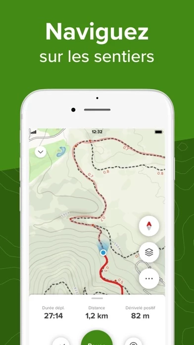
- Record your adventures and turn your phone into a GPS activity tracker
- View your hiking, running, and cycling stats at a glance
- Share your outdoor adventures with friends and family on social media
- Save your favorite trails and follow other users
- Get detailed GPS driving directions directly to the trailhead
- AllTrails Pro offers additional features such as offline maps, off-route notifications, and real-time map overlays
- AllTrails Pro is available as an annual subscription with the option to turn off auto-renewal
- AllTrails allows users to automatically export information about their recordings to the Apple Health app