MarineTraffic Overview
What is MarineTraffic? MarineTraffic is an app that displays near real-time positions of ships and yachts worldwide. It covers most major ports and shipping routes using the largest network of land-based AIS receivers. The app offers features such as vessel tracking, wind forecasts, port arrivals and departures, vessel management, photo browsing, satellite tracking, augmented reality, and route planning. It also offers auto-renewable subscriptions for starter plan, nautical charts, weather maps, and advanced density maps.
Features
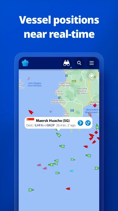
- View vessels on the live map and search for ships, boats, and seaports
- More than 170,000 vessels per day report their positions via MarineTraffic AIS
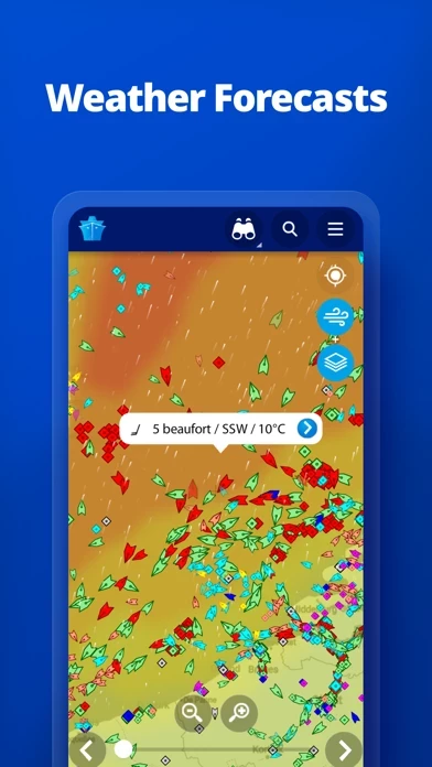
- View live wind and 48-hour wind forecasts on the map
- Animated playback of vessel's track
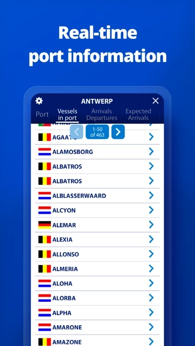
- Port arrivals and departures live for over 4,000 ports and marinas
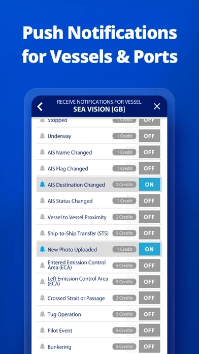
- Manage your list of vessels ("My Fleet"), shared with all your devices and MarineTraffic.com
- Browse 2.5 million photos of ships, harbors, lighthouses, and more
- Upload photos to MarineTraffic directly from your device
- Identify and track vessels sailing beyond the range of land-based AIS receiving stations, using satellite tracking, with Access Plus 24 (in-app purchase)
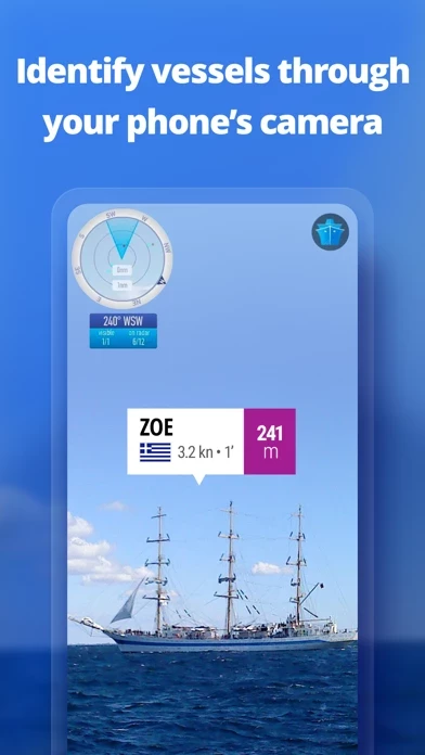
- Identify vessels around you at a glance with the augmented reality tool
- Use the route planner tool to plan a route on the map, measure distances, and calculate ETA
- Auto-renewable subscriptions for starter plan, nautical charts, weather maps, and advanced density maps
- Payment will be charged to iTunes Account at confirmation of purchase
- Subscription automatically renews unless auto-renew is turned off at least 24-hours before the end of the current period
- Account will be charged for renewal within 24-hours prior to the end of the current period, and identify the cost of the renewal
- Subscriptions may be managed by the user and auto-renewal may be turned off by going to the user's Account Settings after purchase
- Terms of Use: https://www.marinetraffic.com/en/p/terms
- Privacy Policy: http://www.marinetraffic.com/en/p/privacy-policy
Official Screenshots
MarineTraffic Pricing Plans
| Duration | Amount (USD) |
|---|---|
| Billed Once | $9.82 |
**Pricing data is based on average subscription prices reported by Justuseapp.com users..
Product Details and Description of
this app displays near real-time positions of ships and yachts worldwide. Using the largest network of land-based AIS receivers, the app covers most major ports and shipping routes. • View VESSELS ON THE LIVE MAP, search for ships, boats and seaports and see what's near you! • More than 170,000 VESSELS PER DAY report their positions via this app AIS • View live wind and 48-hour WIND FORECASTS on the map • ANIMATED PLAYBACK of vessel's track • PORT ARRIVALS & DEPARTURES live for over 4,000 ports and marinas, current conditions in ports and estimated time of arrival for the boats & ships. • Manage your list of vessels ("MY FLEET"), shared with all your devices and this app.com • Browse 2.5 MILLION PHOTOS of ships, harbours, lighthouses and more! • Upload photos to this app directly from your device. • Identify and track vessels sailing beyond the range of land-based AIS receiving stations, using satellite tracking, with ACCESS PLUS 24 (in-app purchase) • Identify vessels around you at a glance with the AUGMENTED REALITY tool Just point your device's camera to the horizon and get all the information you need about vessels, ports and lighthouses in your area: name, flag, speed, distance from you and a lot more. • Use the ROUTE PLANNER tool to plan a route on the map, measure distances and calculate ETA • this app now offers auto-renewable subscriptions for Starter Plan, Nautical Charts, Weather Maps and Advanced Density Maps: Starter Plan - Unlock unlimited features like extended vessel and port details, vessel track, Advanced Search, Vessels near me, Augmented Reality and more Subscription name: Starter Plan Annual Cost: $9.99 (USD) Renewed every year i.e. you will be charged annually Get access to the marine environment with Nautical Maps - Pilotage information such as sea bed, sea marks and landmarks - Port details such as berths, dry docks and terminal location - Position and characteristics of buoys, lights, lighthouses - Depths of water and heights of land Subscription name: Nautical Charts Monthly Cost: $6.99 (USD) Renewed every month i.e. you will be charged monthly Subscription name: Nautical Charts Annual Cost: $66.99 (USD) Renewed every year i.e. you will be charged annually Unlock real-time & forecast weather information with Weather Maps - Wind contours - Wind flow & gusts - Temperature - Wave metrics - Clouds and Precipitation - Ocean currents - More than 20 key metrics - 7-days sea meteogram Subscription name: Weather Maps Layers Monthly Cost: $8.99 (USD) Renewed every month i.e. you will be charged monthly Subscription name: Weather Maps Layers Annual Cost: $95.99 (USD) Renewed every year i.e. you will be charged annually Advanced Density Maps - Dig into global shipping traffic data, filtering by vessel type. Subscription name: Advanced Density Maps Monthly Cost: $1.99 (USD) Renewed every month i.e. you will be charged monthly Subscription name: Advanced Density Maps Annual Cost: $17.99 (USD) Renewed every year i.e. you will be charged annually For all the above subscriptions: • Payment will be charged to iTunes Account at confirmation of purchase • Subscription automatically renews unless auto-renew is turned off at least 24-hours before the end of the current period • Account will be charged for renewal within 24-hours prior to the end of the current period, and identify the cost of the renewal • Subscriptions may be managed by the user and auto-renewal may be turned off by going to the user's Account Settings after purchase • Any unused portion of a free trial period, if offered, will be forfeited when the user purchases a subscription to that publication, where applicable Terms of Use: https://www.this app.com/en/p/terms Privacy Policy: http://www.this app.com/en/p/privacy-policy Join the great this app community!
Top Reviews
By ldels
Glad I took the leap
After using the desk top version of this I decided to download the app. I almost didn’t after reading reviews stating you had to pay for info on each vessel. After downloading I ran into the same issue, HOWEVER there is a super simple fix to see the vessel names/basic stats. For some reason the app does not default to this; but if you go to settings-map options- you will see “vessel names”, you just have to toggle that on and you will be able to see them for free. A few took a few minutes to update but overall it is working just as the desktop version does.
By viking621956
Your recent update seems to have turned off the ability to filter vessels...
Right now I am using this app to track a single vessel on which I will soon be taking a cruise. I used to be able to filter out all other vessels as a default. Now with your recent update, while I can still do this, it doesn’t stay that way and all vessels keep on coming back. This clutters up the map a bit, and it is annoying to constantly have to go back and reset this filter. Other than that this is a great app and I enjoy it very much. Thank you.
By Winjama
Tracking Made Easy!
I’m an old Navy Radarman from before everything was computerized. This software has revolutionized the ocean shipping industry as far as being able to keep track of vessels of concern. I know we could have used this as an additional tool that would have proven itself in short order. I live in Belize and like to track the vessels coming down here from Florida so I can keep track of where items might be at that I’ve purchased and shipped down. It makes for a fun hobby too - kinda like train spotting used to be.