How to Cancel MarineTraffic
Published by MarineTraffic.com on 2023-12-06We have made it super easy to cancel MarineTraffic - Ship Tracking subscription
at the root to avoid any and all mediums "MarineTraffic.com" (the developer) uses to bill you.
Complete Guide to Canceling MarineTraffic - Ship Tracking
A few things to note and do before cancelling:
- The developer of MarineTraffic is MarineTraffic.com and all inquiries must go to them.
- Check the Terms of Services and/or Privacy policy of MarineTraffic.com to know if they support self-serve subscription cancellation:
- Cancelling a subscription during a free trial may result in losing a free trial account.
- You must always cancel a subscription at least 24 hours before the trial period ends.
How easy is it to cancel or delete MarineTraffic?
It is Impossible to Cancel a MarineTraffic subscription. (**Crowdsourced from MarineTraffic and Justuseapp users)
If you haven't rated MarineTraffic cancellation policy yet, Rate it here →.
Pricing Plans
**Gotten from publicly available data and the appstores.
-Starter Plan Annual
Cost: $9.99 (USD)
Renewed every year
- Nautical Charts Monthly
Cost: $6.99 (USD)
Renewed every month
- Nautical Charts Annual
Cost: $66.99 (USD)
Renewed every year
- Weather Maps Layers Monthly
Cost: $8.99 (USD)
Renewed every month
- Weather Maps Layers Annual
Cost: $95.99 (USD)
Renewed every year
- Advanced Density Maps Monthly
Cost: $1.99 (USD)
Renewed every month
- Advanced Density Maps Annual
Cost: $17.99 (USD)
Renewed every year
Potential Savings
**Pricing data is based on average subscription prices reported by Justuseapp.com users..
| Duration | Amount (USD) |
|---|---|
| If Billed Once | $9.82 |
How to Cancel MarineTraffic - Ship Tracking Subscription on iPhone or iPad:
- Open Settings » ~Your name~ » and click "Subscriptions".
- Click the MarineTraffic (subscription) you want to review.
- Click Cancel.
How to Cancel MarineTraffic - Ship Tracking Subscription on Android Device:
- Open your Google Play Store app.
- Click on Menu » "Subscriptions".
- Tap on MarineTraffic - Ship Tracking (subscription you wish to cancel)
- Click "Cancel Subscription".
How do I remove my Card from MarineTraffic?
Removing card details from MarineTraffic if you subscribed directly is very tricky. Very few websites allow you to remove your card details. So you will have to make do with some few tricks before and after subscribing on websites in the future.
Before Signing up or Subscribing:
- Create an account on Justuseapp. signup here →
- Create upto 4 Virtual Debit Cards - this will act as a VPN for you bank account and prevent apps like MarineTraffic from billing you to eternity.
- Fund your Justuseapp Cards using your real card.
- Signup on MarineTraffic - Ship Tracking or any other website using your Justuseapp card.
- Cancel the MarineTraffic subscription directly from your Justuseapp dashboard.
- To learn more how this all works, Visit here →.
How to Cancel MarineTraffic - Ship Tracking Subscription on a Mac computer:
- Goto your Mac AppStore, Click ~Your name~ (bottom sidebar).
- Click "View Information" and sign in if asked to.
- Scroll down on the next page shown to you until you see the "Subscriptions" tab then click on "Manage".
- Click "Edit" beside the MarineTraffic - Ship Tracking app and then click on "Cancel Subscription".
What to do if you Subscribed directly on MarineTraffic's Website:
- Reach out to MarineTraffic.com here »»
- Visit MarineTraffic website: Click to visit .
- Login to your account.
- In the menu section, look for any of the following: "Billing", "Subscription", "Payment", "Manage account", "Settings".
- Click the link, then follow the prompts to cancel your subscription.
How to Cancel MarineTraffic - Ship Tracking Subscription on Paypal:
To cancel your MarineTraffic subscription on PayPal, do the following:
- Login to www.paypal.com .
- Click "Settings" » "Payments".
- Next, click on "Manage Automatic Payments" in the Automatic Payments dashboard.
- You'll see a list of merchants you've subscribed to. Click on "MarineTraffic - Ship Tracking" or "MarineTraffic.com" to cancel.
How to delete MarineTraffic account:
- Reach out directly to MarineTraffic via Justuseapp. Get all Contact details →
- Send an email to [email protected] Click to email requesting that they delete your account.
Delete MarineTraffic - Ship Tracking from iPhone:
- On your homescreen, Tap and hold MarineTraffic - Ship Tracking until it starts shaking.
- Once it starts to shake, you'll see an X Mark at the top of the app icon.
- Click on that X to delete the MarineTraffic - Ship Tracking app.
Delete MarineTraffic - Ship Tracking from Android:
- Open your GooglePlay app and goto the menu.
- Click "My Apps and Games" » then "Installed".
- Choose MarineTraffic - Ship Tracking, » then click "Uninstall".
Have a Problem with MarineTraffic - Ship Tracking? Report Issue
Leave a comment:
Reviews & Common Issues: 1 Comments
By Phillip cozens
2 years agoPlease cancel my account as I do not require the services , Many thanks for you help in this service Regards Phil Cozens , Can you please confirm the above 0413 703 200
What is MarineTraffic - Ship Tracking?
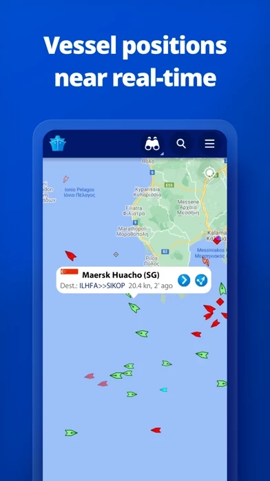
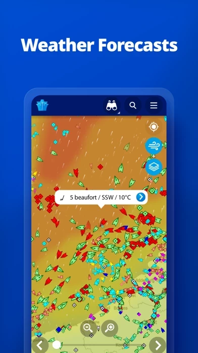
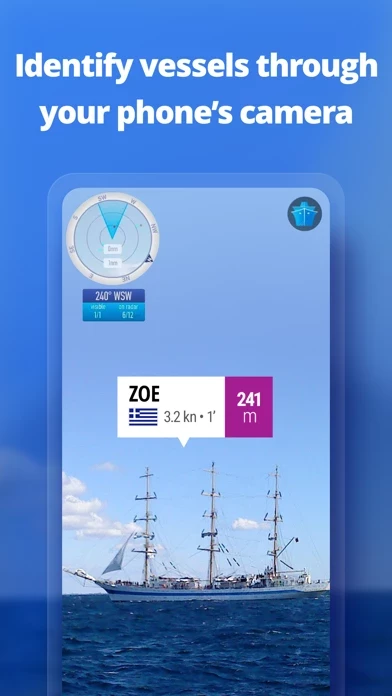
this app displays near real-time positions of ships and yachts worldwide. Using the largest network of land-based AIS receivers, the app covers most major ports and shipping routes. • View VESSELS ON THE LIVE MAP, search for ships, boats and seaports and see what's near you! • More than 170,000 VESSELS PER DAY report their positions via this app AIS • View live wind and 48-hour WIND FORECASTS on the map • ANIMATED PLAYBACK of vessel's track • PORT ARRIVALS & DEPARTURES live for over 4,000 ports and marinas, current conditions in ports and estimated time of arrival for the boats & ships. • Manage your list of vessels ("MY FLEET"), shared with all your devices and this app.com • Browse 2.5 MILLION PHOTOS of ships, harbours, lighthouses and more! • Upload photos to this app directly from your device. • Identify and track vessels sailing beyond the range of land-based AIS receiving stations, using satellite tracking, with ACCESS PLUS 24 (in-app purchase) • Identify vessels around you at a glance with the AUGMENTED REALITY tool Just point your device's camera to the horizon and get all the information you need about vessels, ports and lighthouses in your area: name, flag, speed, distance from you and a lot more. • Use the ROUTE PLANNER tool to plan a route on the map, measure distances and calculate ETA • this app now offers auto-renewable subscriptions for Starter Plan, Nautical Charts, Weather Maps and Advanced Density Maps: Starter Plan - Unlock unl...