MarineTraffic Présentation
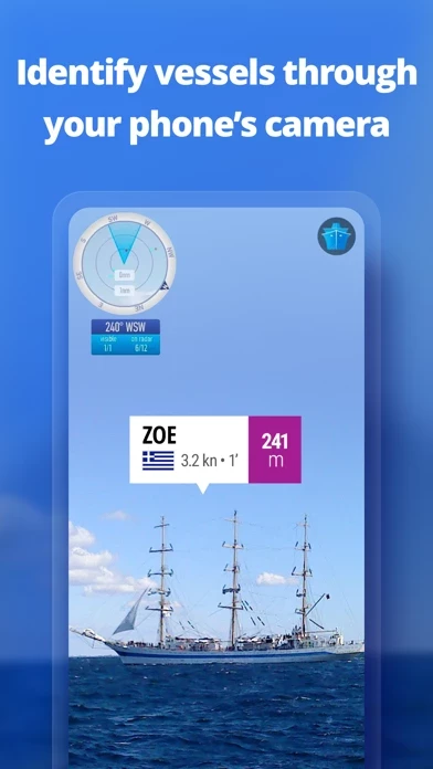
Just point your device's camera to the horizon and get all the information you need about vessels, ports and lighthouses in your area: name, flag, speed, distance from you and a lot more.
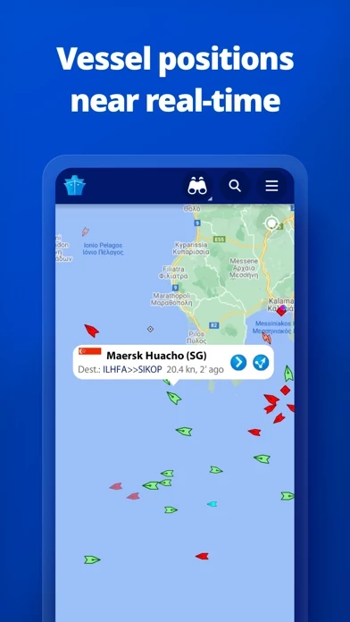
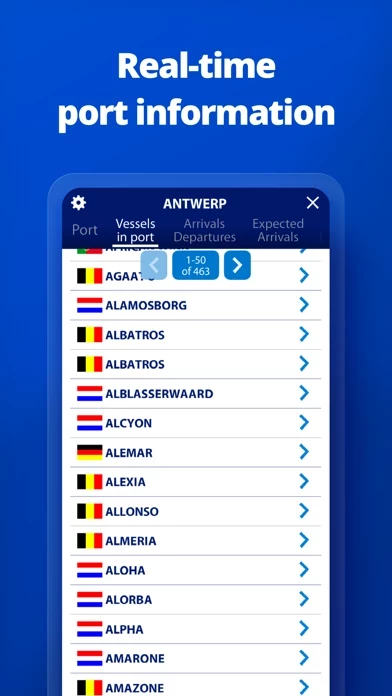
• PORT ARRIVALS & DEPARTURES live for over 4,000 ports and marinas, current conditions in ports and estimated time of arrival for the boats & ships.
Using the largest network of land-based AIS receivers, the app covers most major ports and shipping routes.
Captures d'écran officielles
MarineTraffic Forfaits tarifaires
| Durée | Montant (USD) |
|---|---|
| Facturé une fois | $9.82 |
**Les données de tarification sont basées sur les prix d'abonnement moyens indiqués par les utilisateurs de Justuseapp.com..
Détails du produit et description de
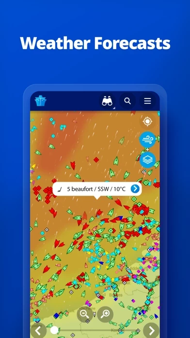
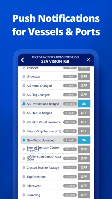
l’application displays near real-time positions of ships and yachts worldwide. Using the largest network of land-based AIS receivers, the app covers most major ports and shipping routes. • View VESSELS ON THE LIVE MAP, search for ships, boats and seaports and see what's near you! • More than 170,000 VESSELS PER DAY report their positions via l’application AIS • View live wind and 48-hour WIND FORECASTS on the map • ANIMATED PLAYBACK of vessel's track • PORT ARRIVALS & DEPARTURES live for over 4,000 ports and marinas, current conditions in ports and estimated time of arrival for the boats & ships. • Manage your list of vessels ("MY FLEET"), shared with all your devices and l’application.com • Browse 2.5 MILLION PHOTOS of ships, harbours, lighthouses and more! • Upload photos to l’application directly from your device. • Identify and track vessels sailing beyond the range of land-based AIS receiving stations, using satellite tracking, with ACCESS PLUS 24 (in-app purchase) • Identify vessels around you at a glance with the AUGMENTED REALITY tool Just point your device's camera to the horizon and get all the information you need about vessels, ports and lighthouses in your area: name, flag, speed, distance from you and a lot more. • Use the ROUTE PLANNER tool to plan a route on the map, measure distances and calculate ETA • l’application now offers auto-renewable subscriptions for Starter Plan, Nautical Charts, Weather Maps and Advanced Density Maps: Starter Plan - Unlock unlimited features like extended vessel and port details, vessel track, Advanced Search, Vessels near me, Augmented Reality and more Subscription name: Starter Plan Annual Cost: $9.99 (USD) Renewed every year i.e. you will be charged annually Get access to the marine environment with Nautical Maps - Pilotage information such as sea bed, sea marks and landmarks - Port details such as berths, dry docks and terminal location - Position and characteristics of buoys, lights, lighthouses - Depths of water and heights of land Subscription name: Nautical Charts Monthly Cost: $6.99 (USD) Renewed every month i.e. you will be charged monthly Subscription name: Nautical Charts Annual Cost: $66.99 (USD) Renewed every year i.e. you will be charged annually Unlock real-time & forecast weather information with Weather Maps - Wind contours - Wind flow & gusts - Temperature - Wave metrics - Clouds and Precipitation - Ocean currents - More than 20 key metrics - 7-days sea meteogram Subscription name: Weather Maps Layers Monthly Cost: $8.99 (USD) Renewed every month i.e. you will be charged monthly Subscription name: Weather Maps Layers Annual Cost: $95.99 (USD) Renewed every year i.e. you will be charged annually Advanced Density Maps - Dig into global shipping traffic data, filtering by vessel type. Subscription name: Advanced Density Maps Monthly Cost: $1.99 (USD) Renewed every month i.e. you will be charged monthly Subscription name: Advanced Density Maps Annual Cost: $17.99 (USD) Renewed every year i.e. you will be charged annually For all the above subscriptions: • Payment will be charged to iTunes Account at confirmation of purchase • Subscription automatically renews unless auto-renew is turned off at least 24-hours before the end of the current period • Account will be charged for renewal within 24-hours prior to the end of the current period, and identify the cost of the renewal • Subscriptions may be managed by the user and auto-renewal may be turned off by going to the user's Account Settings after purchase • Any unused portion of a free trial period, if offered, will be forfeited when the user purchases a subscription to that publication, where applicable Terms of Use: https://www.l’application.com/en/p/terms Privacy Policy: http://www.l’application.com/en/p/privacy-policy Join the great l’application community!
Haut Avis
Par beb alberto
A quand la version française
A quand la version en français urgente
Par 1coorect
Bien mais...
Très bien MAIS On croit que c’est gratuit pour un an une fois qu’on a payé l’appli et après il faut payer toutes les 24 heures !!!!!!!!
Par Éner
Appli très intéressante
Habitant en face des îles de Hyères, cette appli permet de connaître et reconnaître les bateaux qui croisent en face de chez moi et même parfois très loin de chez moi..... Les photos et les indications sont intéressantes, dommage que pour les bâtiments militaires il faille prendre les jumelles, relever leur matricule et aller sur le net pour voir de quel navire il s’agit!!! Pour moi très bonne appli Merci