FlyQ EFB Software
Company Name: Seattle Avionics, Inc.
About: Spectralux Avionics is an aviation & aerospace company providing data link communication equipment.
Headquarters: Redmond, Washington, United States.
FlyQ EFB Overview
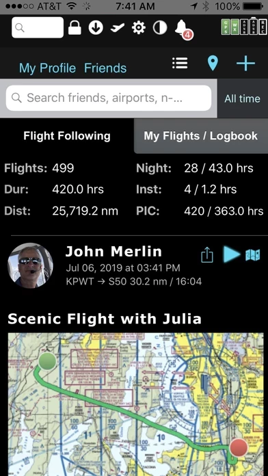
What is FlyQ EFB? FlyQ EFB is a top-rated aviation app that integrates powerful features to make flying easier and safer. It offers a Global Digital Map, 4D Predictive Weather, Augmented Reality, Slingshot wireless ChartData system, Visual Logbook, and Post Flight Playback/Analysis Graphs, among others. The app supports more than 20 ADS-B and in-panel devices and includes split screen, 3D synthetic vision, plates on the map, more than 4,600 airport diagrams, rich Documents support, extended runways, distance measurement, fuel prices, NOTAMS, wind-optimized flight planning, and plates/diagrams for Mexico and Central America.
Features
- Digital, 2D maps, 3D Syn Vis, Augmented Reality
- Sectionals and IFR charts
- Photo, road, terrain maps
- 17 Weather Layers
- Flight Track
- Fuel Prices
- TFRs
- Obstacle and Terrain Avoidance
- ADS-B Traffic and Weather
- Extended runways with right-pattern indicators
- Procedures on map
- Rings / Extended Course Line
- CAP grid
- Heli and Gulf of Mexico charts
- VFR Flyways
- Syn Vis includes HITS boxes, EFIS display, TAWS, Obstacles, and AHRS support
- Night Mode
- Split screen (iPad only) and single screen
- Seattle Avionics geo-referenced approach plates and apt diagrams
- Annotate plates and diagrams with colored lines and text
- Flight Planning that Saves Time and Money
- CAP/SAR patterns
- Exchange flight plans with Dynon SkyView, Avidyne, and Aspen
- Practice with X-Plane or MS Flight Sim / Prepar3D
- Amazing "4D Predictive Weather"
- Graphical Wind Optimizer
- Extensive gallery of weather images
- Airport Information
- More than 4,600 SA Airport Diagrams
- Data Manager
- Free 30-day subscription
Official Screenshots


Product Details and Description of
FlyQ EFB is a top-rated aviation app because it makes your flying easier and safer by thoughtfully integrating powerful features in a way that minimizes the number of screen taps and uses larger fonts to increase readability. The new Global Digital Map shows airports, airways, airspace, navaids, and waypoints from all around the world. Text rotates so it's always right-side up and the level of detail adapts to the zoom level. Our exceptional "4D Predictive Weather" system uses a Timeline and Altitude Slider to help you analyze weather at different times - both past and future - and at different altitudes. 17 weather layers from both the Internet and ADS-B (e.g. Radar, Icing, Turbulence, PIREPs, Winds Aloft, Surface Winds, Surface Analysis, Satellite, and more), many tied to the Timeline and Altitude Slider, give you unprecedented pre-flight and in-flight safety. Supports more than 20 ADS-B and in-panel devices: Stratus 3, Avidyne, Dynon, Stratux, and more. The exclusive Augmented Reality (AR) feature provides situational awareness you'd previously only seen in sci-fi movies. The Slingshot wireless ChartData system means FlyQ supplies maps, plates, and apt diagrams wirelessly to certified systems from BendixKing. The Visual Logbook and Post Flight Playback / Analysis Graphs add a whole new dimension to your flying. Optionally connect with your friends to "see" and even replay their flights. CFI's can track student progress and remotely send endorsements. Other key features include split screen, 3D synthetic vision, plates on the map, more than 4,600 airport diagrams, rich Documents support, extended runways, distance measurement, fuel prices, NOTAMS, wind-optimized flight planning, and plates/diagrams for Mexico and Central America. > Maps Your Way + Digital, 2D maps, 3D Syn Vis, Augmented Reality + Sectionals and IFR charts + Photo, road, terrain maps + 17 Weather Layers + Flight Track + Fuel Prices + TFRs + Obstacle and Terrain Avoidance + ADS-B Traffic and Weather + Extended runways with right-pattern indicators + Procedures on map + Rings / Extended Course Line + CAP grid + Heli and Gulf of Mexico charts + VFR Flyways + Syn Vis includes HITS boxes, EFIS display, TAWS, Obstacles, and AHRS support. Night Mode preserves your night vision. Split screen (iPad only) and single screen. > Procedures FlyQ includes the same Seattle Avionics geo-referenced approach plates and apt diagrams that we certified for FAA DO-200A compliance with certified avionics from BendixKing and Aspen. Split screen can show a map and a procedure simultaneously. Swipe to switch procedures or tap to list all procedures at an airport. Overlay procedures on a map. Annotate plates and diagrams with colored lines and text. > Flight Planning that Saves Time and Money 1. Automatically uses recently cleared ATC routes (IFR only) 2. Automatically plans fuel stops based on lowest cost and uses expected winds to plot the fastest course, saving time and money on every flight. 3. CAP/SAR patterns 4. Exchange flight plans with Dynon SkyView, Avidyne, and Aspen. 5. Practice with X-Plane or MS Flight Sim / Prepar3D > Weather Amazing "4D Predictive Weather" uses a Timeline and Altitude slider to make detailed pre-flight and in-flight analysis easy. The Graphical Wind Optimizer uses red and green bars to show the headwind or tailwind at different altitudes. Also includes an extensive gallery of weather images. > Airport Information The Airport screen concisely shows key operational info, sat images, and runway diagrams on a single screen. weather, approach procedures, A/FD, and FBO info are just a tap away. Includes more than 4,600 SA Airport Diagrams. > Data Manager FlyQ makes it painless to download new data every month: spin and zoom a 3D globe to visually select the states you're interested in. > Try it before you buy it Experience everything FlyQ EFB offers with a free 30-day subscription.
Top Reviews
By Xxcxxxxxccxcccxccx
Reliable easy to use and capable.
App Store for FlyQ For the past year I have used FlyQ in our Cessna 182 with the G1000 Nav III package along with the Merlin ADS-B receiver and have found it extremely easy to use and very reliable. Having flown for more than 50 years as an instrument rated pilot it is stunning how much information is presented in such a usable fashion to help get the needed big picture and then drill down to the details needed for accurate planning in challenging conditions. It is also gives me a great sense of security knowing that despite having an excellent Nav system and back up instruments that the FlyQ/Merlin system gives me a completely independent system for back up using my tablet to navigate if the G1000 goes dark would be my first choice, the back up instruments would be a fall back because the AHRS in the Merlin package is so stable. I am using another EFB system as well but prefer the FlyQ for inflight use and preflight planning.
By The original Bob2
New VFR user
I sampled 3 EFBs before deciding on FlyQ. I found it to be the easiest to learn and use. I actually used the 30 day free trial and my wife's old iPad to fly a Piper Cherokee 140 from First Flight airport (FFA) in North Carolina to Guthrie Edmond Regional (GOK) in Oklahoma. As soon as I got home, I bought my own iPad mini and paid my annual subscription for FlyQ. I also canceled my VFR Chart subscription with Sportys. That alone will more than balance the cost of the FlyQ annual subscription. I have always had current paper charts but now I can pay less once a year and have ALL the charts. I'm not really looking forward to buying ADS-B out. But I am looking forward to having ADS-B in because of the in-flight weather and traffic. I expect a high percentage of general aviation to forgo ADS-B out, but at least I'll be able to see all commercial and regional traffic right on the iPad! I feel safer already. Thanks to all those at Seattle Avionics for making FlyQ EFB such a great app. It has it all and I love it. One year later... I built the dual band Stratux ADS-B-In receiver using the Raspberry kit. All for under $100. It works perfectly with FlyQ!!! Now I see traffic and weather on the latest sectional charts and my actual flight path. Very slick! Seattle Avionics keeps getting better. I expect to get the least expensive ADS-B-Out when it is required. Maybe the new uAvionix wingtip unit or a Garmin GDL 82.
By Straight Tail 172
Great EFB
I’ve been using FlyQ for several years now and I really like it because of the essential features and ease of use. I compared FlyQ to another EFB app but found the other app had more features that were of no interest to me and it seemed a bit more complicated than it needed to be. Also, FlyQ includes geo-referenced charts that the other app didn’t in its basic product (you would have to pay for the higher priced version if you wanted this feature). Like one other review that I’ve read, I’m not crazy about the Version 4 release. I’m a firm believer in the KISS principle. For me personally, a few tweaks to the pre-Version 4 release will really make this an outstanding product. Lastly, customer support at Seattle Avionics is very good.