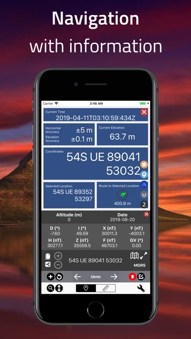
Coordinates Overview
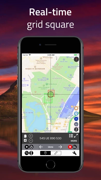
Not only the app specifies Longitude / Latitude, but also supports a number of coordinate formats and systems, i.e., Universal Transverse Mercator Coordinate System (UTM), Military Grid Reference System (MGRS), World Geographic Reference System (Georef), etc.
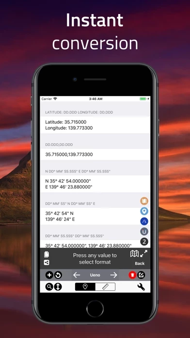
Transform point coordinates from one coordinate system to another, including datum transformations using PROJ.4 cartographic projections library.
Payment for subscriptions will be charged to your iTunes Account at confirmation of purchase Subscription automatically renews unless auto-renew is turned off at least 24-hours before the end of the current period.
The app is able to transform coordinates within EPSG , ESRI, IAU2000 references from online database, and convert X & Y coordinates, geodetic datums and projected systems.
Official Screenshots
Product Details and Description of
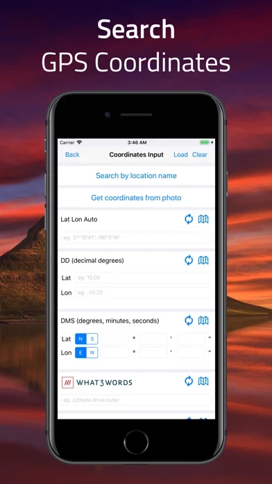
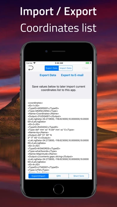
Simple and Easy App to determine various-format this app # User-friendly Design # Your current location will automatically appear as the point of intersection of two grey lines, and can also be manually indicated via value-input, location search, and import from clipboard functions as well. # Support of Various Coordinate Formats # Not only the app specifies Longitude / Latitude, but also supports a number of coordinate formats and systems, i.e., Universal Transverse Mercator Coordinate System (UTM), Military Grid Reference System (MGRS), World Geographic Reference System (Georef), etc. # Datum Conversion # The app is able to transform this app within EPSG , ESRI, IAU2000 references from online database, and convert X & Y this app, geodetic datums and projected systems. # Tracking and Navigation # Pin your desired location on the map to start navigation. Real-time bearing/distance update and large coordinate readout for on-the-field usage are available. # World Magnetic Model Calculator # The app utilizes World Magnetic Model WMM 2015 and/or WMM 2015v2, and is able to compute geomagnetic-field values: i.e., magnetic declinations, intensity, magnetic grid variation, etc. # Elevation / Altimeter # Elevation/altitude data is accessible within landmass area. # Import / Export - AirDrop supported # - Export current this app list. - Import previously-created file to migrate or backup this app data between devices. - .gpx file supported # Distance measurement # Distance is measured by pinpointing locations, or drawing lines to create your own route. # Bearing Calculation # Initial bearing and final bearing between this app points can be calculated. # PROJ.4 Calculator # Transform point this app from one coordinate system to another, including datum transformations using PROJ.4 cartographic projections library. # Apple Watch Support # Apple Watch support is available, view the this app of your current location in various formats. # Supported Input / Output # Latitude and Longitude in Decimal Degrees Latitude and Longitude in Degrees and Decimal Minutes Latitude and Longitude in Degrees, Minutes, and Seconds Standard UTM NATO UTM MGRS / USNG Georef QTH Locator / Maidenhead (WGS84) World Mercator (WGS84) Web Mercator Geohash what3words Global Area Reference System (GARS) Ordnance Survey National Grid [BNG] OSGB36 ISO 6709 Natural Area Code Irish Grid Reference Irish Grid this app Plus Code (Open Location Code) Mapcode Dutch Grid ECEF Indian Kalianpur 1975 Open Postcode Geohash-36 Guatemala GTM RT90 SWEREF99 Indian 1975 QND95 / Qatar National Grid IRENET95 / Irish Transverse Mercator KOSOVAREF01 HD 72 / EOV Kertau (RSO) / RSO Malaya (m) Timbalai 1948 / RSO Borneo (m) EST97 Estonian 1997 LKS92 / Latvia TM NZGD49 NZGD2000 CH1903 CH1903+ GGRS87 ETRS89-extended / LAEA Europe NTF (Paris) / Lambert zone II French DFCI Grid ARINC 424 FMS ARC1950 Search by location name Photo location metadata Proj.4 formats # Subscriptions # “this app – GPS Formatter,” including all of its features, is completely FREE to use. You can subscribe to this application to remove ads Device subscriptions are available in these plan and will renew automatically each month, six months or year, unless cancelled (Per month) $2.99 (Per six-months) $15.99 (Per year) $28.99 Price may vary by location. Payment for subscriptions will be charged to your iTunes Account at confirmation of purchase Subscription automatically renews unless auto-renew is turned off at least 24-hours before the end of the current period. Subscriptions may be managed by going to your iTunes Account Settings after purchase or by clicking the “Purchase / Manage Subscription. Auto-renewal may be turned off by going to Account Settings after purchase. Subscription cannot be cancelled during the active subscription period Privacy policy: https://mapnitude.com/privacy-policy Terms of use: https://mapnitude.com/terms-of-service
Top Reviews
By charlesuh60m
Address to mgrs
I’m a military medevac pilot and would love if I could put in an address or intersection and the the mgrs for it. Having that could better help save lives.
By M. Ali Patwary
Works with Apple Watch
Really enjoy the simplicity of this app. You can get grid coordinate on your watch. Makes life easier.
By scenographer
Excellent tool for SAR
Great app! Simple, fast access to various datum and coordinate systems for communicating with other resources or support units, who may be using a different system from your SAR operation.