Fishing Points - Lake Maps Software
Company Name: Bist LLC
About: BIST Group is an IT and audio visual solutions where every customer is an individual.
Headquarters: Bingley, Bradford, United Kingdom.
Fishing Points Overview
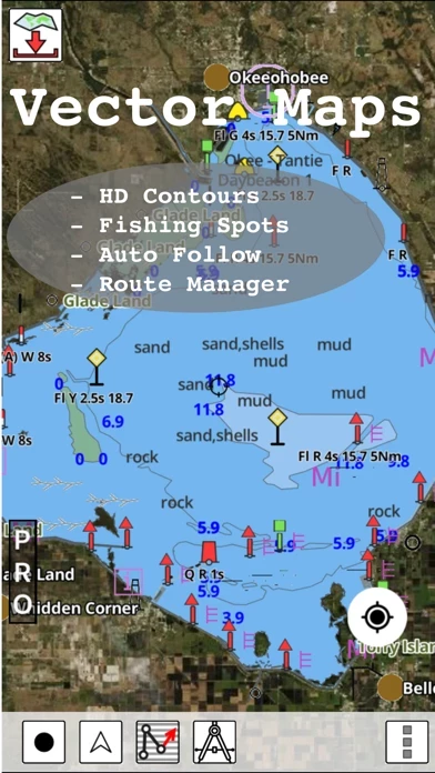
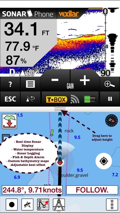
Coverage includes NOAA marine vector charts,freshwater lake maps,USACE inland river maps (HD/1ft/3ft bathymetry.
This App offers access to Fishing Lake Depth Maps & Marine Charts for USA, Canada (other regions coming soon).
Official Screenshots
Product Details and Description of
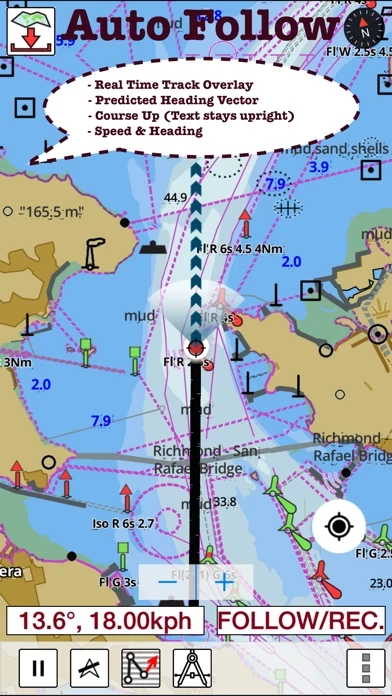
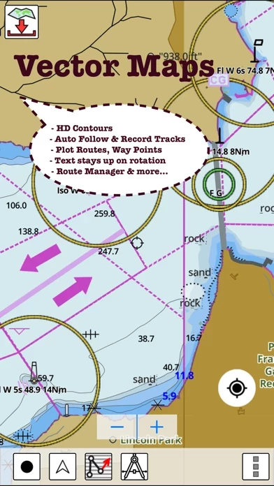
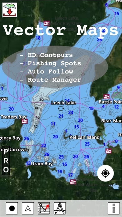
This App offers access to Fishing Lake Depth Maps & Marine Charts for USA, Canada (other regions coming soon). Coverage includes NOAA marine vector charts,freshwater lake maps,USACE inland river maps (HD/1ft/3ft bathymetry. First marine GPS app to have route assistance with Voice Prompts for marine navigation. You can create new boating routes or import existing GPX/KML routes. It supports Nautical Charts course up orientation. Includes Tide & Currents prediction. ►FEATURES √ Beautiful & detailed Hardware/GPU accelerated vector charts (text stays upright on rotation) √ Long press to query the details of Marine object (Buoy,Lights,Obstruction etc). √ Customizable depth(Ft/Fathom/Meter) & distance units(km/mi/NM) √ Customizable Shallow Depth. √ Record tracks,Autofollow with real-time track overlay & predicted path vector. √ Voice Prompts for marine navigation (requires GPS ) √ 1ft / 3ft depth contour maps for anglers for selected lake maps. √ Supports GPX/KML for boating route editing/import. √ Tide & Currents prediction. √ Seamless chart quilting of marine charts √ Enter or import Waypoints. ► MAPS It includes unlimited updates for 1 year. √ Florida Lake Maps & Nautical Charts ►ROUTE MANAGEMENT / TRIP PLANNING √ Create New Route/Edit Existing Routes √ Move Points √ Add points to an existing route leg √ Delete / Rename points √ Import GPX,KML & KMZ files √ Plot/Edit Routes √ Enter Waypoints √ Share/Export Routes,Tracks&Markers √ Reverse Routes ►GPS FEATURES √ Auto Follow * Real Time Track Overlay * Predicted Path Vector * Course Up(Text stays upright) * Speed & Heading √ Route Assistance With Voice Prompts * Prompts when approaching a boating route marker * Continous distance & ETA updates * Alerts when sailing/boating off route * Alerts when boating in wrong direction √ Record Tracks ►TIDE & CURRENTS * For US, Canada, UK, Germany & New Zealand * High/Low Tides * Tidal Current Prediction * Active Current Stations ► SHARING * Share tracks/routes/markers on Facebook & Twitter * Export tracks/routes/markers as compressed GPX files. Sample Charts √ KISSIMMEE, Lake Apopka, ISTOKPOGA, SEMINOLE, TOHOPEKALIGA, Lake Tohopekaliga, HARRIS, Lakeocklawaha, √ East Lake Tohopekaliga, Bighenderson, GRIFFIN, MONROE, TALQUIN, Lake Eustis, EUSTIS, WEOHYAKAPKA, √ ORANGE , HARNEY, MICCOSUKEE, HATCHINEHA, SANTA FE SWAMP, Farm 13 Stick Marsh, Weir, √ LOCHLOOSA , Crooked Lake, MARIAN, DEER POINT , HANCOCK, ROSALIE, √ DORA, POINSETT, CROOKED , SANTA FE , RIVER STYX, Lake Yale, √ YALE, CYPRESS , Lake Louisa, KERR, ARBUCKLE, PIERCE, June, JACKSON, PANASOFFKEE, √ ALLIGATOR , DOCTORS , REEDY , OKAHUMPKA SWAMP, Jackson, Forest North, ROUSSEAU, MARION, √ WASHINGTON, JOHNS , TARPON, Lake Minnehaha, HAMILTON, WOODRUFF, TIGER , √ DEXTER, PARKER, SAMPSON, COBB MARSH, Lake Minneola, GENTRY, DORR, BUTLER, Kingsley, √ WINDER, TRAFFORD, BUFFUM, Josephine, TIBET, CLINCH, OKAHUMPKA, √ LITTLE SANTA FE , ELOISE, Cherry Lake, BEAUCLAIR, MATTIE, CONWAY, SOUTH , √ OTTER SLOUGH, Bigsand, ASHBY, ARIANA, Hampton, CYPRESS CREEK, JULIANA, , PLEASE NOTE: Continued use of GPS running in the background can dramatically decrease battery life.
Top Reviews
By ZOOMBIE CAT
Love it !!!!!!
Today was the day I used this app out on the water and I have to say it worked flawlessly. I would recommend to anyone as a matter of fact I have had are whole fishing group ask me the name of the app as they were also super impressed.
By CCCanal11
Scituate, MA
I’m an inexperienced boater in a small Boston Whaler sailing through rock infested waters. This app was discovered by my daughter while we were maneuvering at mid tide back to the harbor. The app showed depths and obstacles all around us. This app is more than advanced technology. This app brings us now into the realm of Harry Potter.
By DJSmitty88
Very satisfied
This helped very much since I was unable to bring my fish finder on my fishing trip this year. Had fished the lake before but did not know exactly where the 15' channel was where the fish usually were.