Fishing Points Overview
What is Fishing Points?
The Fishing Points app is designed to help anglers prepare for their fishing trips by providing solunar data, tide prediction, and weather forecast. The app allows users to save and find their favorite fishing and hunting locations, spots, trotlines, and trolling paths. It also provides worldwide nautical charts, suitable for both saltwater and freshwater anglers. The app enables users to create a fishing log and save the details of every catch, including photos, weight, and length.
Features
- Save fishing locations, hotspots, waypoints with 40+ new markers and 10 colors to choose from
- Record trolling paths and trotlines
- Draw trolling routes and tracks
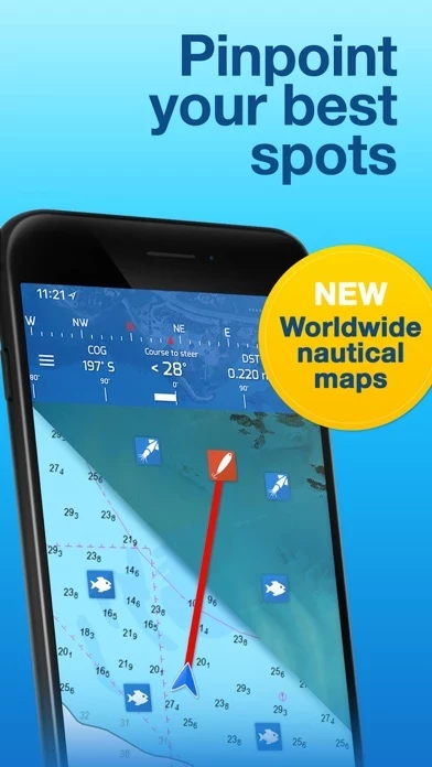
- Find saved locations with GPS
- Worldwide nautical charts
- Measure distances
- Set anchor location, monitor your movements, and get alerted if you exceed allowed distance
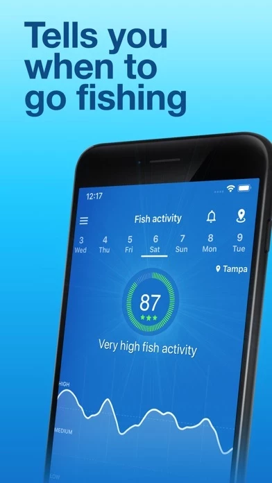
- Daily fish activity forecast
- Best fishing times calendar
- Feeding times (major and minor times)
- Hourly waves forecast (waves, swell, wind waves)
- Sea temperature (SST)
- Sea currents
- Current weather conditions and hourly forecast
- Wind forecast
- Severe weather alerts
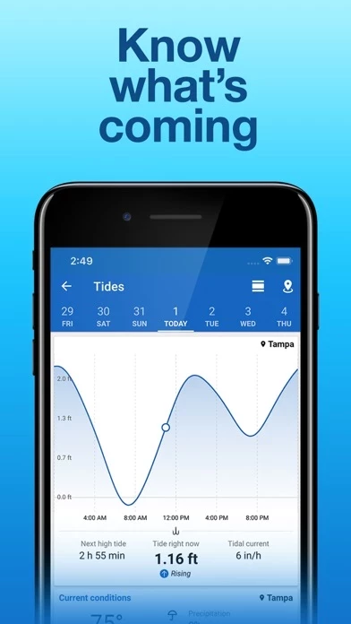
- Tide prediction charts
- Barometer and hourly air pressure data
- Sunrise and sunset times
- Sun positions
- Moonrise and moonset times
- Moon positions
- Moon phases
- Almanac
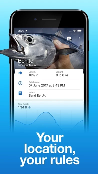
- Save catches and create fishing log
- Share catch photos
- Import kmz or gpx files from GPS devices or other apps
- Share your locations with friends
- Free to download and use
- Premium version available on a yearly or monthly subscription basis with additional features.
Official Screenshots
Fishing Points Pricing Plans
| Duration | Amount (USD) |
|---|---|
| Billed Once | $17.99 |
| Yearly Subscription | $31.23 |
**Pricing data is based on average subscription prices reported by Justuseapp.com users..
Product Details and Description of
Prepare for fishing trip and find the best fishing times using solunar data, tide prediction and weather forecast. Fishing Points app enables you to save and find your favourite fishing and hunting locations, spots, trotlines and trolling paths. Enjoy the best satellite view from Google Maps or use offline mode with nautical charts (US - NOAA) for boating. Suitable for saltwater anglers (inshore or offshore fishing at open seas and oceans) and freshwater anglers (lakes, rivers) applying various fishing techniques fly fishing, bass fishing, boat fishing, kayak fishing, ice fishing. Know your depths, fish smarter, find and catch more with worldwide nautical charts. Create a fishing log and save the details of every catch (photos, weight, length). Weather, sun, moon, marine, waves and tide information are added automatically. FIND YOUR LOCATIONS • Save fishing locations, hotspots, waypoints with 40+ new markers and 10 colours to choose from • Record trolling paths and trotlines • Draw trolling routes and tracks • Find saved locations with GPS • Worldwide nautical charts • Measure distances • Set anchor location, monitor your movements and get alerted if you exceed allowed distance FORECAST • Daily fish activity forecast • Best fishing times calendar • Feeding times (major and minor times) MARINE FORECAST • Hourly waves forecast (waves, swell, wind waves) • Sea temperature (SST) • Sea currents WEATHER & TIDES • Current weather conditions and hourly forecast • Wind forecast • Severe weather alerts • Tide prediction charts • Barometer and hourly air pressure data SOLUNAR DATA • Sunrise and sunset times • Sun positions • Moonrise and moonset times • Moon positions • Moon phases • Almanac FISHING LOG • Save catches and create fishing log • Share catch photos SHARE • Import kmz or gpx files from gps devices or other apps • Share your locations with friends Note: App uses your location for navigation, path recording and weather forecast. Continued use of GPS running in the background when navigating or recording paths can dramatically decrease battery life. The download and usage of Fishing Points App is free of charge. Upgrade to Premium version is available on a yearly or / and monthly subscription basis (price may vary between locations). Should you choose to upgrade to Premium version, payment will be charged to your iTunes account at confirmation of purchase. Your subscription renews automatically unless auto-renew is turned off at least 24 hours prior to the end of the current period. Your account will be charged for renewal within 24-hours prior to the end of the current period, and identify the cost of the renewal. Subscriptions can be managed and auto-renewal may be turned off in your Account Settings in iTunes after purchase. Once purchased, the current period cannot be canceled. Any unused portion of a free trial period, if offered, will be forfeited when the user purchases a subscription to that publication, where applicable. The subscription will renew at the same cost. Privacy policy: https://this app.app/privacy Terms of Use: https://this app.app/terms
Top Reviews
By Sara Isaacs
Great app
This app is incredibly handy. I would like to see the ability to quickly mark depth to make a contour map. I run rivers in my jet boat, so being able to quickly mark waypoints is important. I have used it to mark fishing spots, catches, and to keep track of fish. It should come in handy when ice fishing.
By S.C. Fisherman
Good app
The fish activity and all the information seems to be accurate and it’s my go to app when I’m about to go fishing and trying to get a idea of the water conditions and fish activity.
By 14259982
To Jaydyahoo
Your complaining about the app because it doesn’t show you were to catch fish? You must be joking. Maybe you want the app to reel in your catch also. Smh