Swiss3D Pro Overview
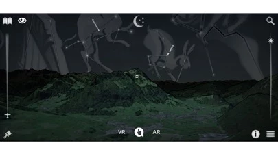
It also rebuild the current time sky and shows all brightest stars, solar system planets and all constellations.
Official Screenshots
Product Details and Description of
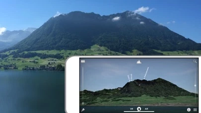
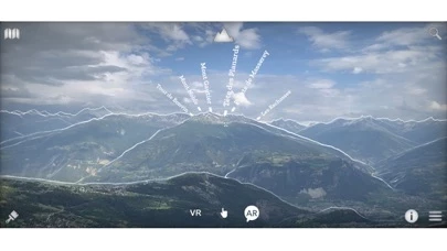
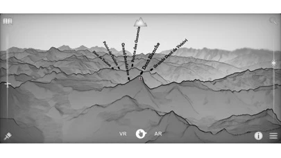
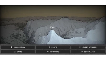
*** Appreciated by "Le Nouvelliste", "mac4ever.com", "iPhone-blog.ch" and perhaps you! *** "Best of Swiss Apps Award 2017" nominated - At which altitude and distance is the cliff over there? - What is the name of this small town below? - How is called the peak we are seeing? - What is the altitude of the Grimsel pass? - Which mountain is the highest of the region? - Is there a camping or a mountain refuge nearby? - What is the name of this glacier or that lake? - Is it Jupiter right over this peak? - The region on this hill has a lot of sun? - How much walk time is needed to reach that crest, is it steep? - Is there any message posted by somebody in this area? - I am asking myself where is the Mattherhorn from here? - What view do we have from the top of this mountain? - Is it full moon and where is the moon? - Is this whole valley over 1000m? ... It is a question list sample that can be answered with Swiss3D! Swiss 3D is a, fully offline, precise, real time, virtual 3D map of Switzerland. It reconstructs your surrounding landscape with accuracy and displays all peaks, towns, cities, places, lakes, passes, glaciers, mountain huts, ... It also rebuild the current time sky and shows all brightest stars, solar system planets and all constellations. The app contains an VR and AR mode that enable you to see the environment as seen through binoculars. You can also share your current favorite position to everybody. Reading a map has never been that fun and easy! Features: ▫ no internet connection required ▫ virtual and augmented reality (ARKit) or manual mode ▫ accurate Swisstopo data ▫ 54000 places, 15000 peaks, 9000 stars, pass, lakes, mountain huts, ... ▫ landsat satellite imagery ▫ summer and winter ▫ search function ▫ dynamic aerial view ▫ easy controls ▫ map ▫ flight simulator ▫ share and comment your favorite location ▫ target information: distance, altitude, slope, sun time, walk time... ▫ only on iOS ▫ made in Switzerland for Switzerland -> iPhone 6s (A9) and more required for the AR! Source: Office fédéral de topographie / geonames Satellite Image: Modified Copernicus Sentinel data [2019] swisstopo, NPOC Elevation Data: ViewFinderPanoramas Stars: Bright Star/Hipparcos catalogue, Jean Meeus Constellations: Stellarium / Johan Meuris pictures Cockpit: Vertical Reality Simulations
Top Reviews
By mel.mike
RO Coverage
Just purchased the Pro. version while hiking in Romania. Unfortunately, the app does not work, even when connected on WiFi. It works in Austria but doesn’t in E Europe. Quite disappointing.
By drrich100
piece of junk
Seems incomprehensible, and mainly designed for Switzerland.. I demand my money back!