Swiss Pro Map Software
Company Name: Andreas Garzotto GmbH
About: Nowy Friends is a mobile app that uses peer-to-peer proximity to power nearby notifications.
Headquarters: Swiss, West Virginia, United States.
Swiss Pro Map Overview
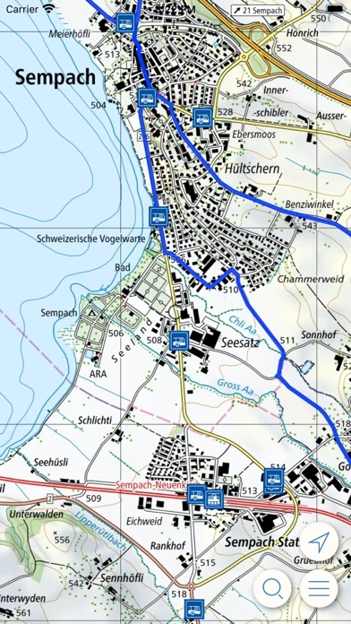
What is Swiss Pro Map? Swiss Pro Map is a map app designed for outdoor activities in Switzerland. It offers offline maps and useful functions for mountain sports, hiking, cycling, and aviation. The app supports important functions such as altitude display, distance and area measurement, search for locations and coordinates, route recording, import and export, offline route planning, etc. The app is free for two weeks from installation, after which a subscription is required for unlimited use.
Features
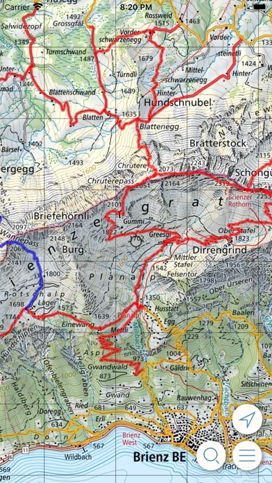
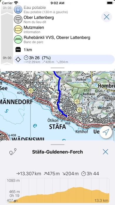
- Offline maps of Switzerland, including the Swiss National Map
- Objects on the map such as hiking trails, public transport stops with timetables, SAC huts, parking spaces, and location descriptions
- Altitude display, distance and area measurement, search for locations and coordinates, route recording, import and export, offline route planning
- Designed for outdoor activities such as mountain sports, hiking, cycling, and aviation
- Free for two weeks from installation, after which a subscription is required for unlimited use
- Yearly subscription available for purchase
- Automatic renewal of subscription unless turned off at least 24-hours before the end of the current period
- Subscriptions can be managed and auto-renewal can be turned off in Account Settings
- Privacy policy and terms of use available on the app's website.
Official Screenshots


Product Details and Description of
Swiss Pro Map is the map app for Switzerland: offline maps and useful functions for outdoor activities such as mountain sports, hiking, cycling and aviation. Maps such as the Swiss National Map, as well as objects on the map, such as hiking trails, public transport stops incl. timetable, SAC huts, parking spaces, location descriptions and much more, once loaded, remain usable offline on the device. The app supports important functions for outdoor activities such as altitude display, distance and area measurement, search for locations and coordinates, route recording, import and export, offline route planning, etc. Swiss Pro Map is free for two weeks from installation. After that, a subscription is required for unlimited use: * The subscription enables unlimited use of the app and finances its maintenance and further development. * It is valid for one year from the date of purchase. * Price of the yearly subscription: See In-App-Purchases * You will be charged with the payment method specified for your Apple ID * The subscription will automatically renew, unless auto-renewal is turned off at least 24-hours before the end of the current period * The account will be charged for renewal within 24-hours prior to the end of the current period, and identify the cost of the renewal * Subscriptions may be managed and auto-renewal may be turned off by going to the Account Settings after purchase * Privacy policy: https://garzotto.com/privacy_en.html * Terms of use: https://garzotto.com/termsofuse_en.html
Top Reviews
By Peregine
Awesome Maps
These are the best topo maps I have ever had the pleasure of using. The detail and clarity are great. The app makes it easy (not cheap, but you pay for convenience, and besides, this is switzerland) to access these maps. The interface has a few oddities, and more color might not be amiss, but I think these are great maps. The biggest downside is that they aren't available elsewhere!
By Chochichaeschtli
Crashes while downloading tiles
3.01 crashes while downloading tiles. At approx. 8,000 tiles the app crashes and has to be restarted. 3.0 had no problems downloading all tiles at once. Please fix the download bug in 3.01. Thank you very much. (Using iPhone 4, iOS 4.1.)
By Randfein
Very useful
For $34, I was able to unlock all 1/25k topographic maps covering a large area for hiking near Interlaken, including the Eiger, Jungfrau, and other areas nearby, along with hiking trails and Swiss Mobility information about public transit, lodging, and points of interest. All of the information is available for offline use, including train, tram, and bus schedules, and can take advantage of my iPad's GPS capabilities. An equivalent amount of paper information would cost considerably more, be much less convenient, and offer much less functionality. The product would be vastly improved by the addition of some basic documentation, but I was able to figure it out in about 20 minutes anyway.