GPS Hiker Overview
It supports GPS track logging, GPX file import/export and offline maps (Open Street Map, Open Cycle Map, Hike Bike and Custom Map Image) download and viewing.
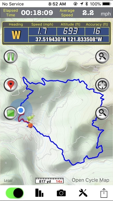
While in the outdoors and without cellular service, you can display currently logging tracks and previously logged tracks made by other parties simultaneously on the offline map to make sure you are on the right track.
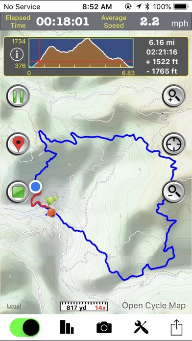
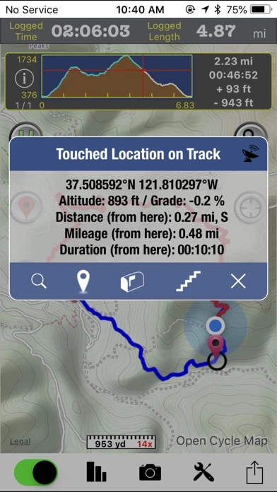
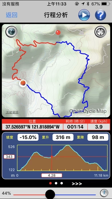
• Trip Analysis allows you walk through the imported tracks in minutes and learn the related mileage, altitude and time information.
Official Screenshots

Product Details and Description of
GPS Hiker is a great and free application for outdoor activities. It supports GPS track logging, GPX file import/export and offline maps (Open Street Map, Open Cycle Map, Hike Bike and Custom Map Image) download and viewing. Camera, twitter and email features are integrated as well. While in the outdoors and without cellular service, you can display currently logging tracks and previously logged tracks made by other parties simultaneously on the offline map to make sure you are on the right track. Photos taken during the logging session can be displayed on the map and saved for later use. You can also follow the previously logged track to assist your navigation and check the mileage and altitude information for reference. GPS Hiker is proudly field-tested at Mission Peak, Fremont, CA, USA. Features: • GPS status (location, speed, heading, altitude) display. • GPS logging & real-time trip information (time, distance, altitude gain/loss. ...) update. • Tracks and marks are stored in the standard GPX format. • You can manually add GPX files to the application via iTune File Sharing. • Import GPX file you download from community websites and display its tracks and marks on map. • Simultaneously display current track logged by yourself and imported track logged by others on map to make sure you are on the right track. • Follow the track of the imported trip to assist your navigation. • Photo Marks: photos taken during the trip will be displayed on the map. Title and description can be added to photos. • Press-To-Find: long-press on the main map to find EveryTrail trips within the visual range of the map. • Press-To-Mark: long-press anywhere on the main map to create marks for your trip. • Multiple color and transparency options to display imported tracks on the map. • Support online maps and offline maps (Open Street Map, Open Cycle Map, Hike Bike and custom map image). • Trip Analysis allows you walk through the imported tracks in minutes and learn the related mileage, altitude and time information. • Trail log to record your hiking activities. • Interactive Altitude Profile Viewer. • Universal Locate button to locate current location, last mark, current trip and imported trip. • GPS switch allows user to switch off GPS, when not in use, to save battery power. • Support WGS84-UTM, WGS84-DMS, WGS84-DEG, TWD67-TM2, TWD97-TM2 coordinate formats. • Take geo-tagged photos with the built-in camera function. • Email your trip to friends after the trip is done. • TweetMark: Tweet your current location and last-taken photo (within 3 minutes) to Twitter. • GPS tracking continues to work in the background while you listen to music or use another application. • Support QR code to download trips. Notice: • This application may continue to use GPS in the background, which can dramatically decrease battery life. • You need to connect your iOS device with iTunes and enable the Application File Sharing feature to add GPX files and custom map images to the application or to retrieve the GPX files for your trips. • This application is not intended for precise navigation. Please use it with good judgement and at user's own risk.
Top Reviews
By F5d7
Fantastic App
After spending hours cobbling together a poor solution using for-fee apps I found GPS hiker and it *rules*. The gpx download worked just as advertised via Itunes. In addition, it automatically caches map tiles near the gpx route so map data is available offline when in the backcountry away from internet. They dont even brag about doing this, it just works! Keep up the great work and many, many thanks. Also, the other 2 reviews available for GPS hiker when I downloaded it are ridiculous. One complains about GPS reliability, a function of your phone, not this app. The other didnt understand that it allows you to turn off GPS whenever you want.
By PW2ofPA
Lots of functionality
I downloaded this app before going on a business trip. I used it to follow the track of my flight from Denver to Las Vegas, which went over the magnificent landscape of southern Utah. I found that I had to experiment with the app to discover its features. After connecting to my phone’s GPS receiver, by tapping an icon on the main screen the app starts logging latitude, longitude and altitude as well as velocity (speed & direction). Touch the camera icon to enable taking a photo which is geotagged and displayed as a marker on the track. You may also add additional markers by tapping a different icon. You may save the log at the end of the trip. The log is stored as a .gpx formatted text file.I was able to drag and drop this file into Google Earth on my Mac. Even though I was not connected to the Internet while I was in the air, it displayed a fairly detailed map. (There is a screen that suggests one may upload some maps into the app, but it isn’t clear to me how this works.) All in all a great app that takes a few minutes to figure out 80% of its capabilities.
By egrier40
Outstanding!
This app is outstanding. It takes some time to learn the interface and all the functionality, but once you get the hang of it, nothing comes close. I use it for both mountain biking and hiking. I run Strava and a couple other bike apps and the elevation numbers are always suspect. I use GPS Hiker for tracking distance as well as elevation and compare to the bike apps. The distance is always close, but the GPS Hiker elevation numbers are much more accurate, i.e., reasonable based on known elevation levels. On a couple occasions the track recorded was a straight line between two points, but I believe it was because the app paused because I stopped for an extended period of time or lost the GPS signal when I was in a covered location and the GPS automatically turned off to save battery. One of the best features of the app is the ability to import and export track data. I build rides and hikes with Google Earth and import the GPX file into the app to track my position on a new route. Offline maps can be downloaded and used with the imported GPX file when off the grid. Rides and hikes can be saved within the app and exported to other apps including Google Earth. It's hard to believe the app is free. I was not expecting all the functionality provided. This app is a must have for hikers and bikers.