GPS Hiker Reviews

GPS Hiker Reviews

Published by

About: GPS Hiker is a great and free application for outdoor activities. It supports
GPS track logging, GPX file import/export and offline maps (Open Street Map,
Open Cycle Map, Hike Bike and Custom Map Image) download and viewing.


About GPS Hiker


It supports GPS track logging, GPX file import/export and offline maps (Open Street Map, Open Cycle Map, Hike Bike and Custom Map Image) download and viewing.

While in the outdoors and without cellular service, you can display currently logging tracks and previously logged tracks made by other parties simultaneously on the offline map to make sure you are on the right track.

• Trip Analysis allows you walk through the imported tracks in minutes and learn the related mileage, altitude and time information.

• You need to connect your iOS device with iTunes and enable the Application File Sharing feature to add GPX files and custom map images to the application or to retrieve the GPX files for your trips.

• Follow the track of the imported trip to assist your navigation.

You can also follow the previously logged track to assist your navigation and check the mileage and altitude information for reference.

• Simultaneously display current track logged by yourself and imported track logged by others on map to make sure you are on the right track.

• Universal Locate button to locate current location, last mark, current trip and imported trip.

• Support online maps and offline maps (Open Street Map, Open Cycle Map, Hike Bike and custom map image).

• GPS logging & real-time trip information (time, distance, altitude gain/loss.

• Import GPX file you download from community websites and display its tracks and marks on map.

• Multiple color and transparency options to display imported tracks on the map.

• Photo Marks: photos taken during the trip will be displayed on the map.

• You can manually add GPX files to the application via iTune File Sharing.


Overall User Satisfaction Rating


Negative experience
50.2%

Positive experience
49.8%

Neutral
47.9%

~ from Justuseapp.com NLP analysis of 14 combined software reviews.

0 GPS Hiker Reviews

2.7 out of 5

See 15 more Reviews


App is now practically useless

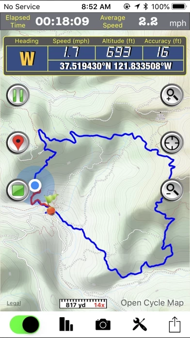
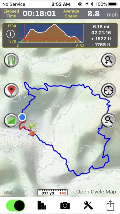
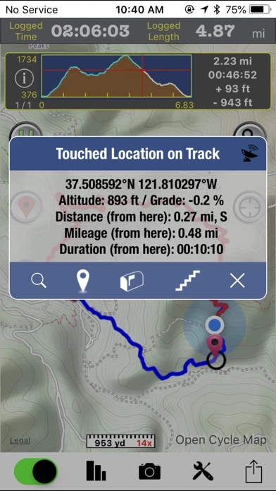
Recently, AllTrails purchased EveryTrail, which GPSHiker was integrated with. When I opened GPSHiker today to prepare for an upcoming hike, it could no longer find the previous "Trips" saved by past users. The park we are going to is one of the most popular state parks in our state, so should've had some existing trails already saved. I then searched the Great Smoky Mountains, which we've used GPSHiker to hike in before, and it still wouldn't bring up past user Trips. I assume this is a result of AllTrails purchasing EveryTrail and AllTrails requires a yearly subscription to save offline maps. Being able to pull up saved trails created by past users allowed us to monitor our progress along those trails. It's nearly impossible to be able to do that for free. Without that capability, GPSHiker has become useless to us. I suppose it will still record your own progress when hiking, but there are a ton of apps out there that will do that.


Fantastic App

After spending hours cobbling together a poor solution using for-fee apps I found GPS hiker and it *rules*. The gpx download worked just as advertised via Itunes. In addition, it automatically caches map tiles near the gpx route so map data is available offline when in the backcountry away from internet. They dont even brag about doing this, it just works! Keep up the great work and many, many thanks.

Also, the other 2 reviews available for GPS hiker when I downloaded it are ridiculous. One complains about GPS reliability, a function of your phone, not GPSHiker. The other didnt understand that it allows you to turn off GPS whenever you want.


Promising, then disappointing

Hadn't used lately. Went on a hike. Tracked with GPSHiker. Took associated pics along the way. Everything went fairly smooth. Got to the end, chose "save and upload". Even though it had previous login info by default, it failed to login. Retried several times. Finally chose "cancel" for the upload, the only other choice. And everything was gone. Previous trip, current trips... all gone. The trip was important to me. What a letdown. I've removed GPSHiker. Do not use GPSHiker!


Nice but unreliable

I've used GPSHiker for the past few years and it's nice that you can put your phone in airplane mode but about half of the time it will lose signal and not track you accurately. Great for a free app but the location services could use some tweaking.


App requires location services to Always be on

I chose not to use app because of this. I don't want my location to be tracked always.


don’t require GPS Always

gps waste battery, pls turn off “always”


Lots of functionality

I downloaded GPSHiker before going on a business trip. I used it to follow the track of my flight from Denver to Las Vegas, which went over the magnificent landscape of southern Utah. I found that I had to experiment with GPSHiker to discover its features. After connecting to my phone’s GPS receiver, by tapping an icon on the main screen GPSHiker starts logging latitude, longitude and altitude as well as velocity (speed & direction). Touch the camera icon to enable taking a photo which is geotagged and displayed as a marker on the track. You may also add additional markers by tapping a different icon. You may save the log at the end of the trip. The log is stored as a .gpx formatted text file.I was able to drag and drop this file into Google Earth on my Mac.

Even though I was not connected to the Internet while I was in the air, it displayed a fairly detailed map. (There is a screen that suggests one may upload some maps into GPSHiker , but it isn’t clear to me how this works.)

All in all a great app that takes a few minutes to figure out 80% of its capabilities.


Outstanding!

GPSHiker is outstanding. It takes some time to learn the interface and all the functionality, but once you get the hang of it, nothing comes close.

I use it for both mountain biking and hiking. I run Strava and a couple other bike apps and the elevation numbers are always suspect. I use GPS Hiker for tracking distance as well as elevation and compare to the bike apps. The distance is always close, but the GPS Hiker elevation numbers are much more accurate, i.e., reasonable based on known elevation levels. On a couple occasions the track recorded was a straight line between two points, but I believe it was because GPSHiker paused because I stopped for an extended period of time or lost the GPS signal when I was in a covered location and the GPS automatically turned off to save battery.

One of the best features of GPSHiker is the ability to import and export track data. I build rides and hikes with Google Earth and import the GPX file into GPSHiker to track my position on a new route. Offline maps can be downloaded and used with the imported GPX file when off the grid. Rides and hikes can be saved within GPSHiker and exported to other apps including Google Earth.

It's hard to believe GPSHiker is free. I was not expecting all the functionality provided. GPSHiker is a must have for hikers and bikers.


Great!

Straightforward, no b.s, no ugly ads, great use of screen real estate. I love GPSHiker. Haven't figured out offline maps yet, but haven't needed that. I can walk with logging on, and it fills in the map when I have wifi or coverage.
Even allows for uploading to a web map or just save trips in app. You can import saved trips back in to analyze later.
The best kind of app. No crashes on iOS 6 for me. "Just works".


Free?! What's the catch?

So, I've been playing with GPSHiker ... The features alone make GPSHiker one of the best apps I've ever used, but being able to download map tiles for offline use? This is amazing and I don't know why GPSHiker is free. I paid $10 for my geocaching app a long time ago. I'd gladly pay even $15 for this. The gps features have proven accurate and, like I said, the features are great! Thanks for GPSHiker!


Honoring licenses

Clearly this tool is heavily used by the people who wrote it. Very nice, and very usable. Lots of features. The the photos to go with waypoints are surpassed only by the offline maps which is an absolute must in an app like this.
The licenses for software libraries and especially map data almost guarantee that this tool can't be sold, so kudos to the authors for writing it anyways.
Many thanks for a very nice tool.


Cool and helpful app

I just used GPSHiker to map a new Potential field trip for a geology course at my university. GPSHiker worked perfectly as described. I wish it could store pictures alongside mark points on the map so when you go back you can see the description and a picture. Keep up the good work and I'm looking forward to the next version!


Absolutely amazing!

I thought it would be garbage since it was free. I would gladly pay $15 or more now that I have used it. You can import routes, drop waypoints, and it tracks everything from altitude, pace, etc. if you want to capture you trail runs or learn new routes, GPSHiker is for you.


Not reliable

This is the first app I have found that records and displays the paths I follow. That is the only reason I give it 3 stars. Unfortunately, its organization is a bit confusing, making it unnecessarily difficult to use. And just today, at the end of a walk, it crashed and lost all the information collected during the walk. I'd say it's a good idea poorly executed.


Good app

Good the only thing missing is offline maps !


Is GPS Hiker Safe?


Yes. GPS Hiker is very safe to use. This is based on our NLP (Natural language processing) analysis of over 14 User Reviews sourced from the Appstore and the appstore cumulative rating of 2.7/5 . Justuseapp Safety Score for GPS Hiker Is 49.8/100.


Is GPS Hiker Legit?


Yes. GPS Hiker is a totally legit app. This conclusion was arrived at by running over 14 GPS Hiker User Reviews through our NLP machine learning process to determine if users believe the app is legitimate or not. Based on this, Justuseapp Legitimacy Score for GPS Hiker Is 97.7/100..


Is GPS Hiker not working?


GPS Hiker works most of the time. If it is not working for you, we recommend you excersise some patience and retry later or Contact Support.


How was your experience with GPS Hiker? Post a Review

Leave a comment:


Alternatives