GPS Hiker Présentation
It supports GPS track logging, GPX file import/export and offline maps (Open Street Map, Open Cycle Map, Hike Bike and Custom Map Image) download and viewing.
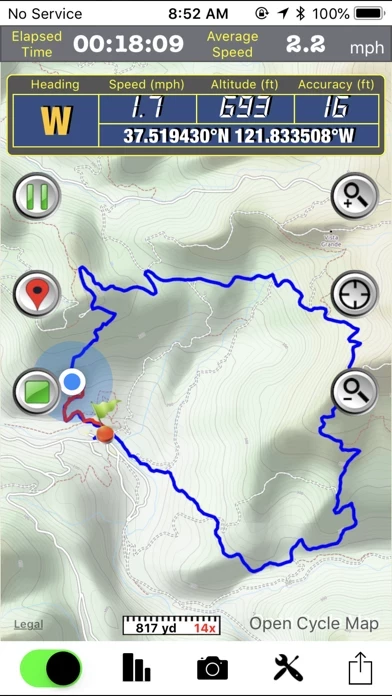
While in the outdoors and without cellular service, you can display currently logging tracks and previously logged tracks made by other parties simultaneously on the offline map to make sure you are on the right track.
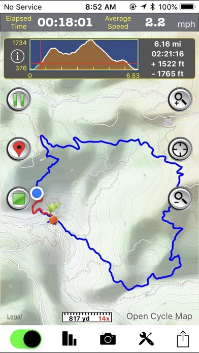
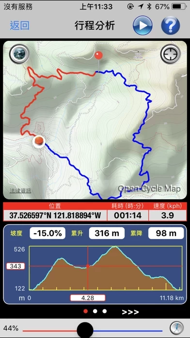
• Trip Analysis allows you walk through the imported tracks in minutes and learn the related mileage, altitude and time information.
Captures d'écran officielles

Détails du produit et description de
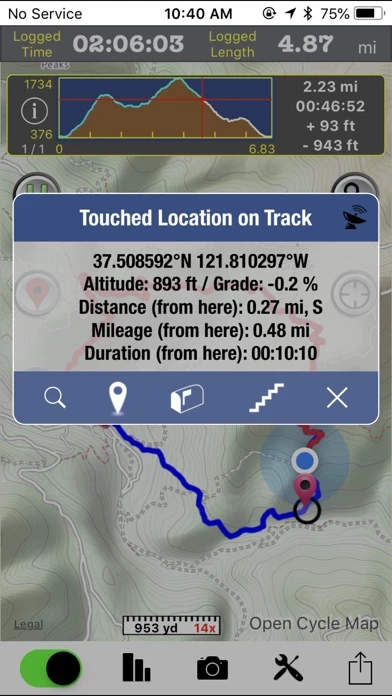
GPS Hiker is a great and free application for outdoor activities. It supports GPS track logging, GPX file import/export and offline maps (Open Street Map, Open Cycle Map, Hike Bike and Custom Map Image) download and viewing. Camera, twitter and email features are integrated as well. While in the outdoors and without cellular service, you can display currently logging tracks and previously logged tracks made by other parties simultaneously on the offline map to make sure you are on the right track. Photos taken during the logging session can be displayed on the map and saved for later use. You can also follow the previously logged track to assist your navigation and check the mileage and altitude information for reference. GPS Hiker is proudly field-tested at Mission Peak, Fremont, CA, USA. Features: • GPS status (location, speed, heading, altitude) display. • GPS logging & real-time trip information (time, distance, altitude gain/loss. ...) update. • Tracks and marks are stored in the standard GPX format. • You can manually add GPX files to the application via iTune File Sharing. • Import GPX file you download from community websites and display its tracks and marks on map. • Simultaneously display current track logged by yourself and imported track logged by others on map to make sure you are on the right track. • Follow the track of the imported trip to assist your navigation. • Photo Marks: photos taken during the trip will be displayed on the map. Title and description can be added to photos. • Press-To-Find: long-press on the main map to find EveryTrail trips within the visual range of the map. • Press-To-Mark: long-press anywhere on the main map to create marks for your trip. • Multiple color and transparency options to display imported tracks on the map. • Support online maps and offline maps (Open Street Map, Open Cycle Map, Hike Bike and custom map image). • Trip Analysis allows you walk through the imported tracks in minutes and learn the related mileage, altitude and time information. • Trail log to record your hiking activities. • Interactive Altitude Profile Viewer. • Universal Locate button to locate current location, last mark, current trip and imported trip. • GPS switch allows user to switch off GPS, when not in use, to save battery power. • Support WGS84-UTM, WGS84-DMS, WGS84-DEG, TWD67-TM2, TWD97-TM2 coordinate formats. • Take geo-tagged photos with the built-in camera function. • Email your trip to friends after the trip is done. • TweetMark: Tweet your current location and last-taken photo (within 3 minutes) to Twitter. • GPS tracking continues to work in the background while you listen to music or use another application. • Support QR code to download trips. Notice: • This application may continue to use GPS in the background, which can dramatically decrease battery life. • You need to connect your iOS device with iTunes and enable the Application File Sharing feature to add GPX files and custom map images to the application or to retrieve the GPX files for your trips. • This application is not intended for precise navigation. Please use it with good judgement and at user's own risk.
Haut Avis
Par Davegigi
Très bien
Très bonne application , les cartes sont précises et bien détaillée pour une appli Gratuite c est du bonheur
Par Zlik'a
Ça pourrait être bien...
... si la fonction de téléchargement des cartes offline marchait ! L'appli est en anglais, et j'ai l'impression qu'elle a un problème avec les iOS français à cause du séparateur décimal. Résultat, impossible de télécharger les cartes offline à partir des coordonnées géographiques :-( A corriger !!