MapOut Overview
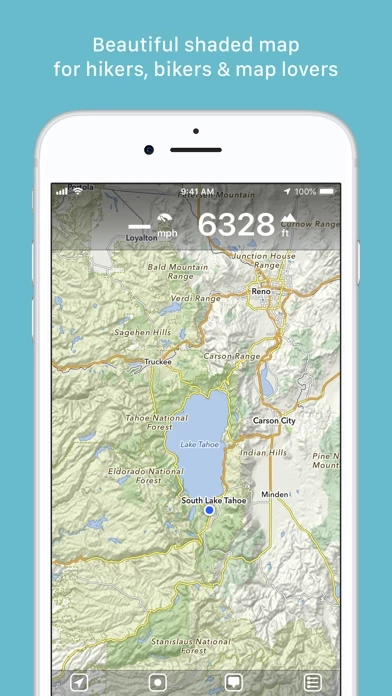
What is MapOut? MapOut is an offline map app for iPhone and iPad that covers the whole world. It offers a simple interface to draw routes, check out elevation profiles, and view maps with tourist information. The app is based on the OpenStreetMap project and allows users to make corrections and additions themselves. It also offers a 3D tilt view and a search feature.
Features
- Offline map covering the whole world
- Easy-to-read representation of the terrain for hikers
- Cycling route network, speed, and distance display for cyclists
- City maps with tourist information for city travelers
- Beautiful map to look at for the connoisseur
- 3D tilt view to get a better impression of the terrain
- Search feature for places, streets, mountains, etc.
- Map material based on the OpenStreetMap project
- Maps can be displayed without an internet connection (offline map)
- Drawing feature to draw your own routes and waypoints directly on the map
- Import feature to import GPX files or directions from MapOut.me account
- Recording feature to take recordings of your own tours and share them with friends
- Quick overview of each tour - length, altitude change, map section, and route profile
- Fast map display (hardware accelerated)
- Step-free zoom, always a pixel-perfect map
- Topographical map with contour lines and shading
- Selectable overlays: Bike/hike/ski routes, sightseeing, public transport
- User manual available at https://mapout.app/manual
- Map data © OpenStreetMap contributors (https://www.openstreetmap.org/copyright)
Official Screenshots


Product Details and Description of
“this app saves the day by using a simple interface to draw routes, and check out elevation profiles… I’m pretty blown away by its capabilities.” – Alee from cyclingabout.com Offline map covering the whole world for iPhone and iPad. Almost as beautiful as a paper map - only more versatile. - For hikers: With an easy-to-read representation of the terrain, even in the furthest corners without internet - For cyclists: With cycling route network, speed and distance display - For city travelers: City maps with tourist information - For the connoisseur: Simply beautiful map to look at 3D tilt view - Tilt the device in any direction to get a better impression of the terrain. More information on https://this app.app. Search feature - Search for places, streets, mountains, etc. No internet connection required. Map material - this app is based on the OpenStreetMap project, the “Wikipedia of Maps” - you can make corrections and additions yourself on OpenStreetMap.org. The latest maps are delivered with periodic updates. - Download the regions of your choice - the maps can now be displayed without an internet connection (offline map). Tours - Drawing: Draw your own routes and waypoints directly on the map. Retouch existing tours and imported GPX files or let them directly snap to the road network. - Import: With a free “this app.me” account you can send directions by email to your device. GPS-Tours can be found as gpx or kml files on many websites with tips for hiking or biking (e.g. on www.gpsies.com) Record: Take recordings of your own tours and share them with friends. Information: Quick overview of each tour - length, altitude change, map section and route profile Map view - Fast map display (hardware accelerated) - Step-free zoom, always a pixel-perfect map - Topographical map with contour lines and shading - Selectable overlays: Bike/hike/ski routes, sightseeing, public transport Find all answers to your questions in our user manual: https://this app.app/manual Map data © OpenStreetMap contributors (https://www.openstreetmap.org/copyright)