i-Boating: Marine Charts & Gps Software
Company Name: Bist LLC
About: BIST Group is an IT and audio visual solutions where every customer is an individual.
Headquarters: Bingley, Bradford, United Kingdom.
i Boating Overview
What is i Boating?
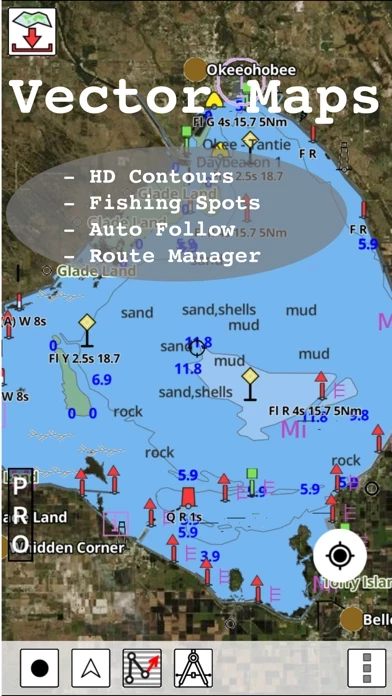
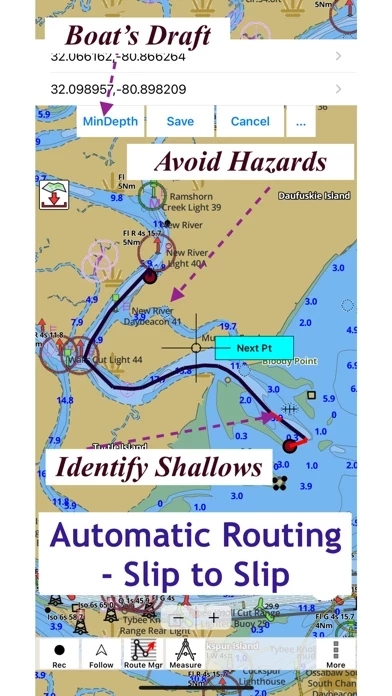
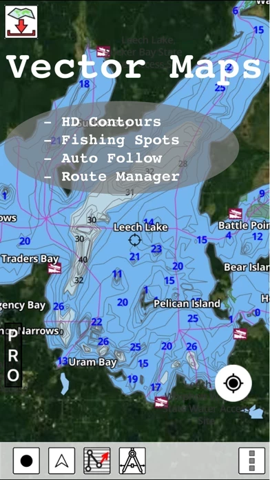
This app provides access to marine charts for various regions including the USA, Canada, UK/Ireland, Germany, Netherlands/Holland, and Europe Rivers. It includes NOAA marine vector charts, freshwater lake maps, USACE inland river maps, and charts derived from UKHO and CHS data. The app offers route assistance with voice prompts for marine navigation, and users can create new boating routes or import existing GPX/KML routes. It also supports nautical charts course up orientation and includes tide and currents prediction.
Features
- Beautiful and detailed hardware/GPU accelerated vector charts
- Long press to query the details of marine objects
- Customizable depth and distance units
- Customizable shallow depth
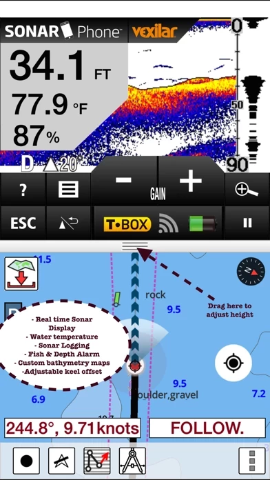
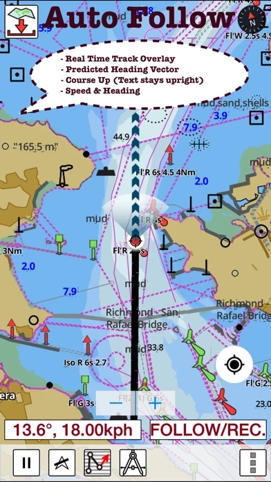
- Record tracks, autofollow with real-time track overlay and predicted path vector
- Voice prompts for marine navigation
- 1ft/3ft depth contour maps for anglers for selected lake maps
- Supports GPX/KML for boating route editing/import
- Tide and currents prediction
- Seamless chart quilting of marine charts
- Enter or import waypoints
- Unlimited updates for 1 year
- Route management/trip planning
- Slip to slip auto routing
- GPS features including auto follow, real-time track overlay, predicted path vector, course up, speed and heading, and route assistance with voice prompts
- Tide and currents information for US, Canada, UK, Germany, and New Zealand
- Instrumentation including marine AIS, wind direction and speed, marine sonar depth, water temperature, and auto pilot
- Sharing options including sharing tracks/routes/markers on Facebook and Twitter and exporting tracks/routes/markers as GPX files.
Official Screenshots
i Boating Pricing Plans
| Duration | Amount (USD) |
|---|---|
| Billed Once | $21.99 |
**Pricing data is based on average subscription prices reported by Justuseapp.com users..
Product Details and Description of
This App offers access to Marine Charts for USA,Canada,UK/Ireland,Germany,Netherlands/Holland & Europe Rivers (Danube,Drava,Rhein etc). Coverage includes NOAA marine vector charts,freshwater lake maps,USACE inland river maps (HD/1ft/3ft bathymetry included where available),charts derived from UKHO & CHS data. First marine GPS app to have route assistance with Voice Prompts for marine navigation. You can create new boating routes or import existing GPX/KML routes. It supports Nautical Charts course up orientation. Includes Tide & Currents prediction. ►FEATURES √ Beautiful & detailed Hardware/GPU accelerated vector charts (text stays upright on rotation) √ Long press to query the details of Marine object (Buoy,Lights,Obstruction etc). √ Customizable depth(Ft/Fathom/Meter) & distance units(km/mi/NM) √ Customizable Shallow Depth. √ Record tracks,Autofollow with real-time track overlay & predicted path vector. √ Voice Prompts for marine navigation (requires GPS ) √ 1ft / 3ft depth contour maps for anglers for selected lake maps. √ Supports GPX/KML for boating route editing/import. √ Tide & Currents prediction. √ Seamless chart quilting of marine charts √ Enter or import Waypoints. ► MAPS It includes unlimited updates for 1 year. √USA: The maps include coverage of all NOAA marine vector charts (ENC),USACE inland river maps,freshwater lake maps for more than 7K lakes. The charts include HD/1ft/3ft bathymetry where available.Incl. NOAA raster where ENC not available. √Canada:Incl. CHS data(incl. major Lakes). √UK/Ireland: Derived from UKHO charts. √Australia √Germany: derived from BSH data √Europe Inland Rivers:Donau/Dunaja,Rhine,Garonne,Moselle,Drava,Sava,etc √Norway √Finland √Sweden √Croatia √Ukraine(Black Sea) √Caribbean √New Zealand √Spain √Brazil √Argentina √Cyprus √Falklands √Seychelles& Mauritius √Denmark √Malta,Cyprus & S. Mediterranean √S. China&Malaysia √South Africa ►ROUTE MANAGEMENT / TRIP PLANNING √ Create New Route/Edit Existing Routes √ Move Points √ Add points to an existing route leg √ Delete / Rename points √ Import GPX,KML & KMZ files √ Plot/Edit Routes √ Enter Waypoints √ Share/Export Routes,Tracks&Markers √ Reverse Routes ►SLIP TO SLIP AUTO ROUTING ►GPS FEATURES √ Auto Follow * Real Time Track Overlay * Predicted Path Vector * Course Up(Text stays upright) * Speed & Heading √ Route Assistance With Voice Prompts * Prompts when approaching a boating route marker * Continous distance & ETA updates * Alerts when sailing/boating off route * Alerts when boating in wrong direction √ Record Tracks ►TIDE & CURRENTS * For US,Canada,UK,Germany & New Zealand * High/Low Tides * Tidal Current Prediction * Active Current Stations ►Instrumentation √ Marine AIS & (NMEA AIS and GPS over TCP/UDP) √ Wind direction & Speed,Marine Sonar depth,Water temperature √ Auto Pilot ► SHARING * Share tracks/routes/markers on Facebook & Twitter * Export tracks/routes/markers as GPX files. SUGARLOAF KEY-KEY WEST PORT RICHEY TAMPA BAY - CLEARWATER HBR EAST BAY-WEST BAY FLORIDA INTRACOASTAL WATERWAY MATECUMBE-GRASSY KEY CHESAPEAKE BAY CAPE CHARLES-NORFOLK HARBOR ANCLOTE KEYS-CRYSTAL RIVER ST JOSEPH SOUND MIAMI HARBOR Minnesota lakes - Kabetogama,Minnetonka,Waconia,Leech,Mille Lacs Lake Keowee,Jocassee,Hartwell,Greenwood,Lake Murray Mark Twain,Ozarks,Table Rock Lake St.Clair Lake Kentucky KEY WEST-THE MISSISSIPPI RIVER SAN PEDRO CHANNEL LAKE MICHIGAN STONY LAKE-POINT BETSIE APALACHICOLA BAY-CAPE SAN BLAS EAST CAPE-MORMON KEY CAPE HENLOPEN-INDIAN RIVER CHESAPEAKE BAY CAPE HENRY-THIMBLE SHOAL DULUTH-SUPERIOR MONHEGAN ISLAND-CAPE ELIZABETH ONTARIO - CLAYTON-FALSE DUCKS Winnipesaukee MIAMI-MARATHON,FLORIDA CAPE MAY-FENWICK ISLAND MISSISSIPPI RIVER-GALVESTON CAPE CANAVERAL-KEY DELAWARE RIVER WILMINGTON-PHILADELPHIA FLORIDA KEYS SOMBRERO KEY-SAND KEY SAN PABLO BAY RAINY LAKE BIG ISLAND MINN-OAKPOINT INTRACOASTAL WATERWAY-BISCAYNE BAY EVERGLADES NTL PARK HURON TAHOE CHESAPEAKE DELAWARE CANAL BACKGROUND GPS CAN DECREASE BATTERY LIFE
Top Reviews
By E. Lile (seconday device)
Professional Level Navigation App
I have been using this app for nearly three years now for professional work on yachts and it has yet to fail me. As with all navigation, I strongly advise users have two different and independent devices running this same app. I, for example, use an iPad Air 2 and an iPhone 7, and for positioning information I use a Garmin GLO and a Bad Elf 2200 GPS signal receiver. The Garmin GLO has temporarily shut down in the past, so it is essential to have the other device running especially when operating in hazardous areas like busy channels, near shoals or barely submerged hazards such as wrecks or isolated rocks. The main improvement I would recommend to Bist LLC at this time would be to offer an in-app purchase cruising guide feature that would enable the user to access critical information about facilities (such as good phone numbers, radio channels etc) by virtue of simply touching the facility name on the current ECS. In the event of emergencies, be they weather or mechanical etc, it would be extremely useful to be able to immediately find the phone number or radio contact information for potential landing sites like marinas.
By breadlover1098
Lake depth maps
Very user friendly app to download lake depth maps and coastal charts. GPS features including recording and moving map works very well and is very reliable. The support is very helpful and answered all the questions I had. I had asked them about a specific lake that was missing. To my pleasant surprise they contacted me today to let me know that they had added depth contours for it and it was a available for download. Update1: I’ve used it quite often in sf a yas well as Sac delta. For navigating the Sac delta I wasn’t able to identify the deep channel. The support was very helpful and suggested me to change the shallow and safety depths. Once I did that I was able to identify the deep channel. I plan to use it in Shasta next week. I am glad they cover it. Will update the review with more details next week.
By LTtheNative
Recommended!!
I recommend this app to anyone looking for a primary or a secondary gps chart plotter. Purchased the US version a few years back for kayak and shoreline fishing in the Tampa Bay Area. Although I have been reduced to the free version after being unable to restore my iCloud when changing phones, I finally bought myself a small boat and got to use this app to find a wreck today. The gps was spot on with this parted iPhone5. No bottom finder test but we were catching fish as soon as we dropped a bait on the sunken sailboat. I will be soon to make the commitment to get the most out of what this app has to offer. If they sent me a shirt and a sticker I would represent this company just like I do for other respectable companies. The team at this app have done a great job on this application.