Aqua Map Overview
What is Aqua Map? The Fishing and Boating app is designed to cater to all the needs of fishing and boating enthusiasts. The app is developed with the help of expert boaters and offers the latest Nautical Charts to ensure safe boating. The app can transform your device into a real ChartPlotter and offers a range of features to plan and navigate your routes and tracks.
Features
- Optimized for both iPhone and iPad
- Download charts on the device for offline use
- Plan and navigate routes and tracks with real-time information
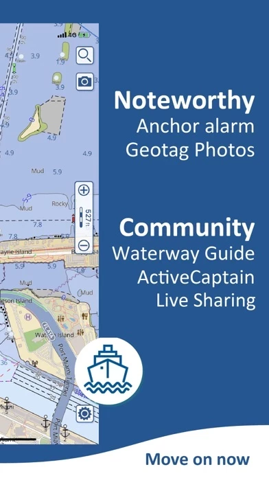
- Anchor alarm with advanced configuration
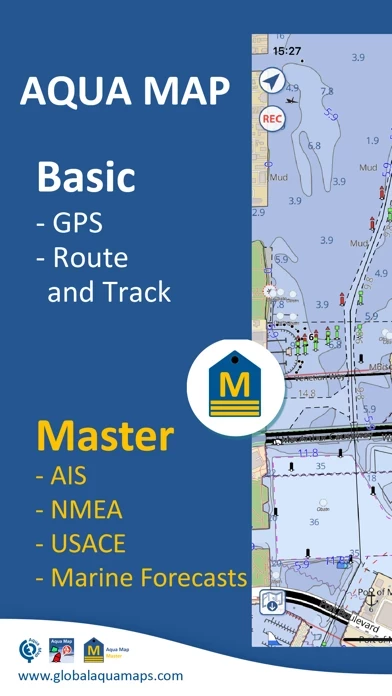
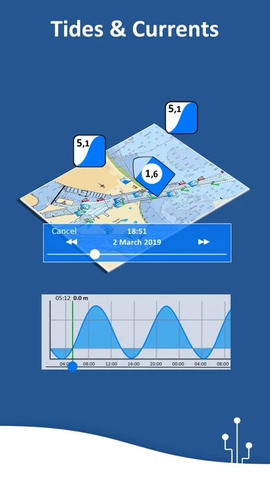
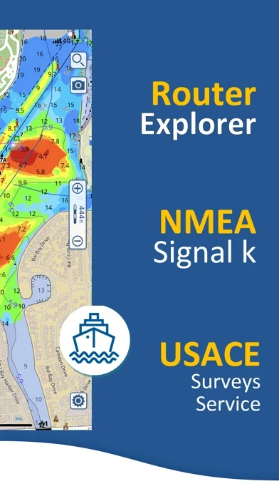
- Tide and current predictions and simulations (North America and Australia)
- Overlay USACE surveys and USCG List of lights on your charts (only US)
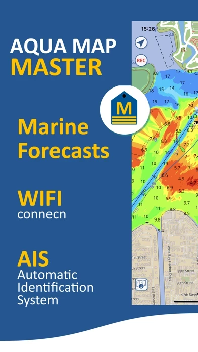
- Access the last marine forecasts (wind, waves, currents, and weather)
- Access more than 1800 weather buoys to get real-time weather conditions
- Share and load tracks, markers, and routes (KMZ and GPX)
- Connect to your friends using the Live Sharing function
- ActiveCaptain and Waterway Guide community integration
- Connect your NMEA devices through WiFi
- Display AIS info from external devices with automatic collision detection
- Powerful search with advanced settings
- Overlay satellite images on your map
- Fully support Light/Dark aspect
- Measure distances on the map
- Check all the bridges, hazards, and best fuel prices along your route
- Works perfectly in iPad multi-screen mode
- Optimized battery usage
- Aqua Map uses only official Nautical charts with depth contours, buoys, lights, etc.
- Plan your trip, insert and edit waypoints
- Navigate your route and your track (NEW) to monitor distance, time (ETA), and direction toward your next waypoint or your final destination
- Anchor alarm to check your GPS position against your anchor position previously defined
- Tides and currents prediction for more than 7500 stations in US, Canada, Bahamas & Australia
- Share your favorite markers on Facebook or send an email with your last daily track
- Live Sharing to exchange data with the Aqua Map community and follow your favorite users on the screen
- ActiveCaptain to join the community of more than 100.000 boaters who write reviews, update data and provide up to date hazard information
- Waterway Guide to access marinas, hazards, anchorages, bridges, free docks, and much more to cover the entire US coastline
- Aqua Map Master to access the last marine forecasts (wind, waves, currents, and weather), connect your NMEA (and SignalK) devices through WiFi, display the AIS targets on the map with automatic collision detection, display the last USACE surveys and the last USCG List of Lights (only US), and consult the Route Explorer with anchorages, bridges, hazards, marinas, and best fuel prices (now available also for tracks)
- Two types of purchases: Unlimited and Subscription.
Official Screenshots
Aqua Map Pricing Plans
| Duration | Amount (USD) |
|---|---|
| Yearly Subscription | $4.99 |
**Pricing data is based on average subscription prices reported by Justuseapp.com users..
Product Details and Description of
An app to satisfy all your Fishing and Boating's needs, developed with the help of expert boaters. Download the best up-to-date Nautical Charts to safely enjoy the new boating season. With the Aqua Map Master transform your device in a real ChartPlotter. ►► Features: • Optimised for both iPhone and iPad • Download the charts on the device for offline use • Plan and navigate your Routes and Tracks with real-time information • Anchor alarm with advanced configuration • Tide & Current predictions and simulations (North America & Australia) • Overlay the USACE surveys and USCG List of lights on your charts (only US) • Access the last marine forecasts (wind, waves, currents and weather) • Access more than 1800 Weather buoys to get real time weather condition • Share and load tracks, markers and routes (KMZ and GPX) • Connect to your friends using the Live Sharing function • ActiveCaptain & Waterway Guide community integration • Connect your NMEA devices through WiFi • Display AIS info from external devices with automatic collision detection • Powerful search with advanced settings • Overlay the Satellite images on your map • Fully support Light/Dark aspect • Measure distances on the map • Check all the bridges, hazards and best fuel prices along your route • Works perfectly in iPad multi-screen mode • Optimized battery usage ► MAPS Aqua Map uses only official Nautical charts with depth contours, buoys, lights, etc. to enjoy the best boating experience. You can download the maps at home within your device and use them on the boat offline (no more Internet connection required). ► ROUTES and WAYPOINTS Plan your trip, insert and edit waypoints. Navigate your route and your track (NEW) to monitor distance, time (ETA) and direction toward your next waypoint or your final destination. ► ANCHOR ALARM This function will check in realtime your GPS position against your anchor position previously defined. An acoustic and visual alarm will run as soon as your GPS position is out of the defined range. ► TIDES & CURRENTS You can calculate the prediction for more than 7500 stations in US, Canada, Bahamas & Australia. See the T&C trend on the map and simulate any future date. ► LOADING and SHARING You can share your favorite's markers on Facebook or send an email with your last daily track. Not only, you can also load any KML, KMZ, GPX (also zipped) found in internet or received from your friends. ► LIVE SHARING Enable the exchange of your data with the Aqua Map community and follow your favorite users on the screen. See all active users around you. You can chat with them and send to them (and receive) your preferred routes/tracks/markers without leaving the Aqua Map application ► ActiveCaptain Join the community of more than 100.000 boaters who write reviews, update data and provide up to date hazard information. ► Waterway Guide Marinas, hazards, anchorages, bridges, free docks and much more to cover the entire US coastline. ► Aqua Map Master Access the last marine forecasts (wind, waves, currents and weather). Connect your NMEA (and SignalK) devices through the WiFi and use their data for all the App functions. Display the AIS targets on the map with automatic collision detection. Display the last USACE surveys and the last USCG List of Lights (only US). Consult the Route Explorer with anchorages, bridges, hazards, marinas and best fuel prices (now available also for tracks). ► TYPE OF PURCHASES - Unlimited: you can download and update your charts forever - Subscription: it is a one year auto-renewable subscription, it will automatically renews unless auto-renew is turned off at least 24-hours before the end of the current period. Subscriptions may be managed by the user and auto-renewal may be turned off by going to the user's Account Settings after purchase Terms of Service: http://www.globalaquamaps.com/Acknowledge.html Privacy Policy: http://www.gec-it.com/GEC-privacy.pdf
Top Reviews
By Brewster81
Purchased but couldn’t use
At the recommendation of a fellow cruiser, I purchased an annual subscription for the Bahamas as a trial. I was able to use it for a short period of time and then kept getting a message that the tutorial period was over. My only thought was that I needed an internet connection to validate my subscription. If that is the case, this app is useless because while cruising, internet access is not reality. Also because I was in the Bahamas, sorting out the problem was not possible. Now back in the US, I want to know what went wrong before purchasing US charts.
By picadillycoop
Great for Navigating the Hudson
Looking for a navigation app to help me on my first trip on the Hudson River. I have a runabout without any electronics so thought I’d try finding an app that would be fun to try and hopefully be of some help. I used it for the first time on the water and it worked flawlessly in helping me keep in the main channel. Seemed to be very accurate in marking the hazards and all of the channel markers that I saw along the way. Worked great for me and made my trip much more enjoyable and I believe, safer.
By JamuJoe
Active Captain Included
I loaded this app and purchased charts because SEAiq lost access to Active Captain after the Garmin acquisition. I am delighted to once again have offline access to Active Captain data. It is limited, though. One cannot create new POI’s or add reviews without being directed to the Garmin Active Captain website. Please, developer, add these features. The nav app itself is very good, although screens are slow to load, even on my new iPad Pro.