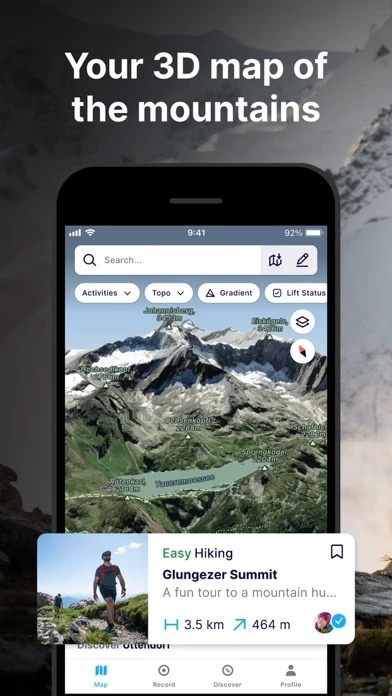
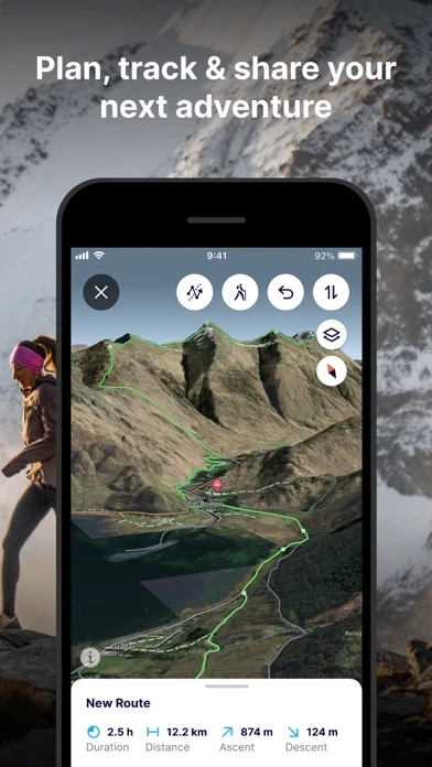
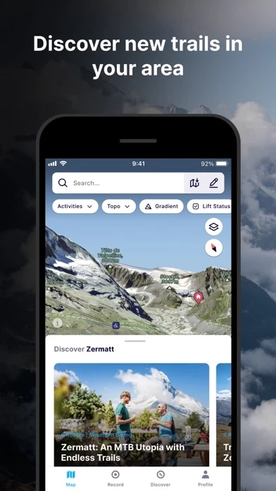
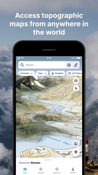
FATMAP: Ski, Hike & Trail Maps Reviews

FATMAP: Ski, Hike & Trail Maps Reviews

Published by on 2023-12-11

About: FATMAP is the #1 app for mountain sports. Explore the mountains with confidence
with the world's most advanced 3D outdoor map.


About FATMAP


What is FATMAP? FATMAP is an app designed for mountain sports enthusiasts. It offers a global 3D outdoor map with real-time information and offline maps for hiking, biking, trail running, skiing, ski touring, and freeriding. The app also provides advanced terrain analysis tools, including slope, elevation, avalanche, and more. Users can record and re-live all their adventures in 3D and share them with the community. FATMAP Explore is a paid membership that offers additional features such as topo map layers, real-time snow conditions, real-time resort status, offline maps, and discounts on outdoor gear.


Features


- Global 3D outdoor map with real-time information and offline maps

- Mountain biking, trail running, hiking, resort and backcountry skiing maps

- Stunning satellite terrain imagery, in summer and winter

- Record and re-live all your adventures in 3D

- Advanced terrain analysis tools including slope, elevation, avalanche and more

- Follow people to see their latest adventures

- Search and find the right route for you or be inspired by the community

- Create and share custom locations / waypoints

- Locate yourself on the map at any time

- Use peak names, roads, footpaths, rivers and heaps of other map data to quickly orientate yourself and navigate to your next objective

- Understand the terrain like never before to make better decisions with Gradient, Avalanche, Flats, Aspect and more layers

- Track your adventure in the app or connect with Suunto, Garmin or Strava to see your tracks in 3D

- Share amazing fly-throughs of your adventure

- Global Topo map or see official topo maps from swisstopo, USGS, IGN, basemap.it and more in 3D (FATMAP Explore feature)

- Real-time snow conditions (FATMAP Explore feature)

- Real-time resort status (FATMAP Explore feature)

- Download any part of the map and use it without an internet connection (FATMAP Explore feature)

- Discounts on outdoor gear (FATMAP Explore feature)


Overall User Satisfaction Rating


Positive experience
52.1%

Negative experience
47.9%

Neutral
40.2%

~ from Justuseapp.com NLP analysis of 196 combined software reviews.

Key Benefits of FATMAP

- Level of zoom detail

- 3D capability

- Fly-over feature

- Terrain Layers

- Snow Depth

- Downloadable Maps

- Limited overlays

- Easy to download maps for offline use

- Explore membership is well worth it

- Helps with planning trips into the back country


20 FATMAP Reviews

3.8 out of 5

By


Best app for exploring outdoor terrain

I now go into my outdoor activities much more informed, and enjoy them a lot more too. I appreciate the level of zoom detail, 3D capability, fly-over feature, Terrain Layers, and Snow Depth. Truly exceptional features. Thanks for this awesome app!

It would be great to be able to overlay the Distance layer on top of the Snow Depth layer. That way I know how long I’ll be traveling over snow to get to my destination. Toggling between the two layers gives me a rough idea but is kinda cumbersome.


By


Good start but needs route discovery

I use Gaia Maps and Maplets (and Google Maps)- all these apps serve a distinct purpose. Unfortunately, FATMAP does deserve the phone memory. On an iPhone SE the UI is a little choppy. FATMAP is like Google Earth, it doesn’t really add any value beyond that for me. And being old fashioned, 2D topo maps are just fine to use when exploring outside.

So what does FATMAP need? I could see something like this being popular once AR is more widespread, but what it’s missing is everything else needed in backcountry navigation like layer support, trail names, route tracking, the ability the effortlessly find new trails.


By


Fantastic app for adventures

One of the best apps around! FATMAP is indispensable for outdoor adventures and objectives. I also use Gaia and CalTopo but always use this app as well. To me, this app is more unique and has some fantastic features. It’s easy to download maps for offline use and the explore membership is well worth it as well. Overall, I couldn’t recommend FATMAP enough!


By


Best outdoor planning app

Being in the mountains all the time, you realize how helpful and safe it is to have a plan of where you are going, where you are sleeping, and how you can get out. this app helps with all of those. It’s like being able to hold the world in your hand and look into any tiny piece of detail before you get there. It’s great


By


Some easy fixes would help

I use it to orient myself to new ski areas before I arrive or maybe after a day or two, and it can be great for that. One huge annoyance: when you press a ski run to see its name and get info, the entire view reorients itself - I guess so you can see the entire run from an angle the developers like. Super annoying to have to re-orient the map manually each time I highlight a run. Makes me afraid to highlight a run at all Please fix this!


By


3D Maps, and offline!!

This is the only good app that has offline 3D maps. It’s huge compared with no offline, and usually no 3D maps at all.
The map visualization is very smooth, even when u add tons of waypoints to it. Great great implementation of the 3D map, better than G_Earth. Easy to share with friends!!


By


Horrible business mode that screwed over past users

I was so excited when I first found FATMAP and started using it. It was great. There were some features you could use for free:

Downloadable Maps
Limited overlays
Etc.

And there were some features that you could access once you purchased a membership.

Until recently, I used FATMAP regularly for scouting my trips into the back country. Then, in the latest major update this company decided that they would require the membership for most of the previously free features like overlays and downloadable maps.

It’s absolutely disgusting when companies offer some features for free for a long time and then all the sudden decide to make those features paid features.

I was going to buy the membership until they pulled this horrible business decision to screw over it’s past users.


By


Doesn’t work offline

FATMAP is trash. Software and mapping is great, but takes up nearly a gig of space downloading an offline map and it doesn’t load the topo when you pull it up. this app is better used on a computer and cross referenced with Gaia GPS or another better offline application. Very disappointed. I’ve now tried to use this on two canyoneering trips in southern Utah, a backcountry ski tour in the wasatch and a 3 day raft trip in Idaho. Worthless. I want my $30 back.


By


Nice update

I am mostly interested in FATMAP to plan backcountry ski tours and the last update fixed the glitches when downloading terrain and slope gradient layers. It’s pretty neat to be able to pan around in 3D with the slope gradient overlay. It would be even better with slope data over the topo layer similiar to caltopo.


By


A useful tool for fun in the alpine!

I usually use Gaia or CalTopo, but this app may soon replace those apps as my go to tool for mapping. Its slope angle shading tool is handy for planning backcountry ski trips and approaches / descents in new terrain, and I appreciate how easy it is to share route and route information, with my colleagues and my clients. The 3D view is fun, too!


By


A step in the right direction

Overall I find it useful for backcountry skiing, but it’s missing a couple features that will prevent me from renewing.
1. You can only import a gpx route from a computer, and not directly into FATMAP from you iPhone.
2 Downloading offline maps is problematic. It’s slow to start( if at all), and takes forever.


By


Great potential, needs improvement

Exactly as the title says, the idea is there, but needs a lot of work. I have faith in this one, meanwhile I’ll use my usual go to apps and keep an eye on this one. I’m in NYC, very little coverage on FATMAP here, but again, this is a relatively new app and I’m sure it’ll keep expanding its database and functionality.


By


Best back country app out there!

Hands down the best and easiest app for plaining backcountry routes! Super easy to navigate and excellent customer service! Also pairs seamlessly with other navigation devices including Garmin Inreach! Highly recommend and will alway add this into my planning on any adventure!


By


No landscape view

I absolutely love the desktop version of this app, so this review is specifically for FATMAP and not the product. The lack of the ability to tilt your phone and view the map in landscape mode is absolutely backbreaking. I love mirroring my phone to my TV and looking at map apps that way when planning a tour (I do this a lot with CalTopo), and I can’t do that with FATMAP. I’d probably pay for premium if there was a landscape view.


By


Beautiful app for outdoor enthusiasts

this app has accurate topography and beautiful 3D visualizations. I use it, and help teach others to use it, when I am evaluating my planned route for a mountain adventure. The connectivity with STRAVA is a fantastic feature to let you review your tracks in 3D. Well worth the download!


By


Loved it but now doesn’t show the ski touring routes it used to

Got FATMAP, saw it had a ton of detail on ski touring routes near me (front range Colorado), loved it and got the membership. Now when I go to the area that used to have all those routes and choose ski touring (berthoud pass) it says there aren’t any routes. Don’t know if it’s a bug or what but it’s incredibly annoying compared to how it was.


By


Awesome app

FATMAP has helped me plan routes and navigate in “unknown” terrain all over Europe.
I’ve been onto FATMAP since the beggining when it had only some resorts. It’s absolutely awesome the way that they have improved it over time!
I’m lucky to have been a beta tester!


By


Winter Satellite Imagery Rocks!

The winter satellite imagery alone is worth downloading FATMAP for if you are a Backcountry skier. Couple that with 3D aspect, elevation, and slope angle data and FATMAP is A+ for trip planning unfamiliar avalanche terrain. It would be awesome to see more areas with winter imagery uploaded! Thanks this app for creating a super useful product!

-Brad Maddock owner Montana Backcountry Yurts


By


Bomber for the backcountry

Started using this last winter and wondered why I haven’t been using FATMAP my whole life! Awesome data for planning backcountry ski missions, finding safe snowmobile zones, and getting into and out of remote wilderness river canyons. If you recreate outside, this is a must!


By


So useful

Loving this new update. When organizing an outing for myself or with clients, it is so smooth to put it on the map and share with others.
Planning any outdoor activity reached new level.
I am super stoked with topographic layers! This on its own is a game changer.


By


Great app

Solid app, has everything I need to find or plan a new outdoor activity


By


Uhm, can’t subscribe

I’d sign up to test for a month but I can’t. When I select “subscribe”, pop up shows me middle of page and I can’t scroll up or down to go thru sign up process. You don’t give me much confidence that this will work when I’m deep on a trail and need to figure out my way.


Is FATMAP Safe?


Yes. FATMAP: Ski, Hike & Trail Maps is very safe to use. This is based on our NLP (Natural language processing) analysis of over 196 User Reviews sourced from the Appstore and the appstore cumulative rating of 3.8/5 . Justuseapp Safety Score for FATMAP Is 52.1/100.


Is FATMAP Legit?


Yes. FATMAP: Ski, Hike & Trail Maps is a totally legit app. This conclusion was arrived at by running over 196 FATMAP: Ski, Hike & Trail Maps User Reviews through our NLP machine learning process to determine if users believe the app is legitimate or not. Based on this, Justuseapp Legitimacy Score for FATMAP Is 92.3/100..


Is FATMAP: Ski, Hike & Trail Maps not working?


FATMAP: Ski, Hike & Trail Maps works most of the time. If it is not working for you, we recommend you excersise some patience and retry later or Contact Support.


Pricing Information

**Pricing data is based on average subscription prices reported by Justuseapp.com users..

FATMAP Explore

- Pricing: $49.99 per year

- Features:

- Global Topo map or official topo maps from swisstopo, USGS, IGN, basemap.it and more in 3D

- Real-time snow conditions

- Real-time resort status (at supported Ski Resorts)

- Offline maps

- Discounts in major partner brands like Mammut, Salomon, Suunto, Faction Skis and many more.


How was your experience with FATMAP: Ski, Hike & Trail Maps? Post a Review

Leave a comment:


Alternatives