RadarScope

RadarScope Software


Company Name:

About: Basevelocity is a mobile development team at tornado alle
Headquarters: , , .

 
  2023-12-04

RadarScope Overview


What is RadarScope?

RadarScope is a weather app designed for weather enthusiasts and meteorologists. It provides access to NEXRAD Level 3 and super-resolution radar data, along with tornado, severe thunderstorm, flash flood, special marine, and snow squall warnings issued by the U.S. National Weather Service. The app can display the latest reflectivity, velocity, dual-polarization, and other products from any NEXRAD or TDWR radar site in the United States, Guam, Puerto Rico, Korea, and Okinawa, as well as data from Environment Canada, Australian Bureau of Meteorology, Finnish Meteorological Institute, and German Weather Service radars.


Features


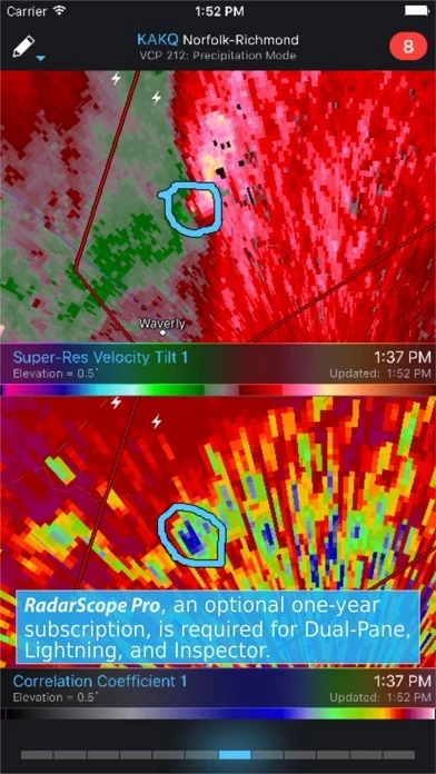
- View NEXRAD Level 3 and super-resolution radar data

- Display tornado, severe thunderstorm, flash flood, special marine, and snow squall warnings issued by the U.S. National Weather Service

- Pinch or stretch to zoom in and out

- Drag your finger around the map to scroll

- Select one of the 289 different radars in the United States, Canada, Australia, Germany, Korea, Puerto Rico, Guam, or Okinawa

- Plot your current location by tapping the location button and optionally report it to the Spotter Network

- Tap the play button to download and animate over recent images

- Display the names of over 25,000 cities and towns on the map as you zoom and scroll

- Tap and hold the color legend to see the data values

- Retrieve and display updated data automatically and intelligently

- Display radar data from our servers, NOAA's public access web site, or your Allison House subscriber account

- RadarScope Pro subscription with two different tiers to choose from

- Real-time lightning data in the U.S. and Canada that animates along with the radar loop

- Up to 30 frames of radar data, including extended loops of super-resolution data

- Data interrogation tool to quickly determine data values for specific radar pixels

- Optional dual-pane mode for viewing two radar products side-by-side

- SPC outlooks, mesoscale discussions, local storm reports, hail size and probability contours, and azimuthal shear contours in the U.S.

- 30-day archive of all radar products

- Ability to use subscription features across multiple platforms

- Privacy policy available for review at: https://www.dtn.com/privacy-policy/


Official Screenshots


RadarScope Pricing Plans

Duration Amount (USD)
Billed Once $26.74

**Pricing data is based on average subscription prices reported by Justuseapp.com users..


Product Details and Description of


this app is a specialized display utility for weather enthusiasts and meteorologists that allows you view NEXRAD Level 3 and super-resolution radar data along with tornado, severe thunderstorm, flash flood, special marine and snow squall warnings, and predicted storm tracks issued by the U.S. National Weather Service. It can display the latest reflectivity, velocity, dual-polarization, and other products from any NEXRAD or TDWR radar site in the United States, Guam, Puerto Rico, Korea, and Okinawa, as well as data from Environment Canada, Australian Bureau of Meteorology, Finnish Meteorological Institute, and German Weather Service radars. These aren't smoothed images, this is native radar data rendered in its original radial format for a high level of detail. Whether you are scanning reflectivity for a mesocyclone's tell-tale hook echo, trying to pinpoint the landfall of a hurricane's eye wall, or looking for small features like velocity couplets in the storm relative radial velocity product, this app gives you the power to view true radial weather radar data. this app displays tornado, severe thunderstorm, flash flood, special marine, and snow squall warnings issued by the U.S. National Weather Service. You can browse the list of active warnings, select a warning to view the details, and even zoom to the selected warning on the map. Pinch or stretch to zoom in and out. Drag your finger around the map to scroll. Tap the radar sweep button in the toolbar to switch radars. Select one of the 289 different radars in the United States, Canada, Australia, Germany, Korea, Puerto Rico, Guam, or Okinawa. Plot your current location by tapping the location button and optionally report it to the Spotter Network. Tap the play button to download and animate over recent images. Display the names of over 25,000 cities and towns on the map as you zoom and scroll. Tap and hold the color legend to see the data values. Meanwhile, this app will retrieve and display updated data automatically and intelligently (approximately every 2 to 10 minutes, depending on the radar scan strategy). You can display radar data from our servers, NOAA's public access web site, or your Allison House subscriber account. Spotter Network members can report their location and view the locations of other spotters. this app Pro is an optional auto-renewing subscription with two different tiers to choose from. this app Pro Tier One is an annual subscription that provides access to real-time lightning data in the U.S. and Canada that animates along with the radar loop and up to 30 frames of radar data, including extended loops of super-resolution data. Tier One subscribers can also access a data interrogation tool to quickly determine data values for specific radar pixels and an optional dual-pane mode for viewing two radar products side-by-side. this app Pro Tier Two is an annual or monthly subscription that combines all the features in Tier One with more advanced features, including SPC outlooks, mesoscale discussions, local storm reports, hail size and probability contours, and azimuthal shear contours in the U.S., a 30-day archive of all radar products, and the ability to use subscription features across multiple platforms. If you choose to buy the this app Pro subscription, it will charged to your iTunes account. The subscription will be auto-renewed within 24 hours prior to the end of the current period at the same price you originally paid. Subscriptions may be managed and auto-renewal disabled via your iTunes Account Settings after the purchase. Once purchased, the subscription cannot be cancelled during the active subscription period. DTN is committed to safeguarding your privacy online. Our privacy policy is available for review at: https://www.dtn.com/privacy-policy/ Please visit our web site for more information.


Top Reviews

By hstnnn

Best radar

The other reviewers are right-- this is the best radar and well worth the cost. I had purchased several others and put off this one because of the price. The other apps disappointed-- they have been inaccurate or slow to update. This one is precise and quick--so far is has never been more than a minute or two before it updates and most often it is up to the moment. And the accuracy has been brilliant. It has many features that I have not yet used, but i hope to learn them soon. I'm a weather novice, but I definitely want to know where the storms are, where they're going, and how much rain we'll get. This is the best radar by far! Update: the developer keeps refining an already brilliant application. This is THE radar application, far superior to any other out there. Absolutely one of the best purchases I've ever made for my iOS devices—beautiful on the iPad, crucial app on the phone, and a very informative glance at the radar on the watch. I bought the upgraded pro version and like the additional features: longer loops and lightening info. As with the basic version of this app, the cost is there but well worth it: this radar and all the features are the some of the best things on my phone. One of the top apps of any kind and one I will subscribe to without hesitation every year.

By Wolf By The Ears

No radar app can hold a candle to this one

I have been a weather nerd since I was a little kid, and I’m a trained Skywarn Storm Spotter. I first downloaded this app in 2013 when a meteorologist mentioned it after I was complaining about how I struggled to find a decent one. Most radar apps have a smoothing algorithm that obliterates storm structure. This app does a beautiful job with with its radar display. I’ve struggled to find certain details like specific rotation data inside a supercell storm, the correlation coefficient to detect tornado debris, decent hurricane reflectivity to see structure of the rain bands as well as the rotation within (I live in Florida), or just basic resolution to see what part of the storm will hit my location. This app does it all and so much more that I could write a book on it. The features of data are endless. I’ve used it through Hurricane Matthew, Irma, and Dorian (and plenty of other tropical storms). The storm season here has me tracking several hundred storms over the years. I have it on my MacBook Pro and my iPhone. There’s a reason all the professionals, scientists, and storm chasers use this app. It’s the best $10 I’ve ever spent.

By PD#453

Not for your average weather enthusiast

Five stars because you’re not going to find anything better. Most people wanting to track the weather are not going to be able to figure out how to use this app. It’s not for those folks. Stick with your news channel weather app. You need to have a little more than a basic understanding of weather and at least some understanding of basic level atmospheric sciences to be able to use this app to its full potential. The features of this app are unmatched. I can watch broad rotation turn to tight rotation then pull up the correlation coefficient view and see what is happening. See where the hail and high winds are down to almost street level. With a little learning you will be able to watch storm movement and know exactly where the danger is or may be approaching. Can’t beat the price for the service you’re getting.


Most Popular Apps in Weather