AR AlpineGuide Overview
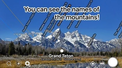
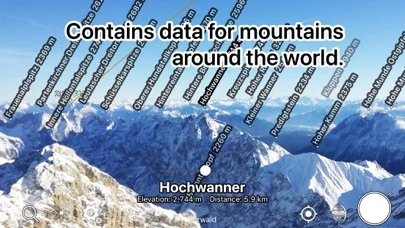
What is AR AlpineGuide? The app is a mountain identification tool that uses augmented reality to display the name, altitude, and distance of the mountaintop when you point your iOS device at it. It has data from nearly one million peaks around the world and all features are free to use.
Features
- Displays the name, altitude, and distance of the mountaintop when you point your iOS device at it
- Identifies the names of all the mountain peaks in the 360-degree panoramic AR view
- Displays three-dimensional coordinates and a gyroscope to display the name at the peak, even if you tilt the camera
- Displays the three-dimensional terrain semi-transparently, making it easy to compare it with the actual shape of the mountain and check the location of the peak
- Switches to a 3D view looking down from the sky when you point your iOS device downward
- Allows you to check the names of the terrain and mountains that can be seen from any location specified on the map
- Lets you take a photo with the name of the peak and share it via SNS or email
- Allows you to adjust the position of the peak name display by swiping the AR display up, down, left, or right
- Lets you adjust the position of the peak name display after the picture is taken
- Allows you to import photos taken with another app and add the peak name
- All features are free to use.
Official Screenshots


Product Details and Description of
Over 1 million downloads total for all platforms! Point your iOS device at the mountain and you'll see the name, altitude, and distance of the mountaintop. You can identify the names of all the mountain peaks in the 360-degree panoramic AR view. All features are free to use. Features - It has data from nearly one million peaks around the world. - It uses three-dimensional coordinates and a gyroscope to display the name at the peak, even if you tilt the camera. The display makes it easy to check. - The three-dimensional terrain is displayed semi-transparently, so it is easy to compare it with the actual shape of the mountain and check the location of the peak. - When you point your iOS device downward, the view switches to a 3D view looking down from the sky. - You can check the names of the terrain and mountains that can be seen from any location specified on the map. - You can take a photo with the name of the peak and share it via SNS or email. - Swiping the AR display up, down, left, or right allows you to adjust the position of the peak name display. - It is possible to adjust the position of the peak name display after the picture is taken. - You can import photos taken with another app and add the peak name. - All the features are free! ※ If the direction is not correct (e.g. it always shows North), if your iOS device has a cover on it If there is a sensor in the case, please remove it. The metal or magnet on the cover may interfere with the sensor and cause it to malfunction. Terms of Service https://www.apple.com/legal/internet-services/itunes/dev/stdeula/
Top Reviews
By Brad Goodman
Freakin’ Incredible
This app is awesome - and they seemed to have added new features which give you overpays of what the mountians are supposed to look like - so you can adjust to get PERFECT registration in the AR view. I was also surprised when it knew where the moon was - and even gave me an overview as to where it would be later on! An absolute MUST HAVE for hikers, mountaineers and sight-seers!!!!
By Williambake
We love this app
The family and I travel across America for my job. We often wondered what mountains are around us. It works good. Thank you.
By InTheAlps
Pretty cool!
Easy to use, far more so than another paid-for app that we gave up on. Worked well in the Aosta Valley where we are staying.