Topo Maps US Reviews

Topo Maps US Reviews

Published by

About: Download and view topographic maps covering the United States. Topographic maps
are useful for recreational activities such as hiking, canoeing, camping,
fishing, mountain biking, geocaching, and exploring.


About Topo Maps US


Import trails (tracks) using GPX files you find on the Internet or from your personal GPS track collection.

Organize your trail types by color, for example, mountain bike trails, hiking trails, and OHV trails.

Share trails with others using email or AirDrop.

Topographic maps are useful for recreational activities such as hiking, canoeing, camping, fishing, mountain biking, geocaching, and exploring.

Record your own trails to show where you've been on the map, follow them later, and share with others.

Share flags with others using email or AirDrop.

Import flags from other sources using GPX files and geocache LOC files.

Recorded trails include an elevation profile (distance/elevation chart).

Download maps for areas of interest to view them later when you don't have Internet access or you don't want to use cell data.

Download and view topographic maps covering the United States.

Organize your flag types by color, for example, geocaches, trailheads, and summits.

Trails are included with map downloads.

Add flags (waypoints) to the map to mark your current location or other locations.

Choose from 2 map sources: USGS standard topographic or USGS hybrid topographic.


Overall User Satisfaction Rating


Positive experience
63.9%

Negative experience
36.1%

Neutral
14.8%

~ from Justuseapp.com NLP analysis of 168 combined software reviews.

Key Benefits of Topo Maps US

- No need for a user account to access maps

- Maps can be saved for offline use

- Live GPS locating and photo location import features

- Clear and readable maps

- Free of charge

- Useful for hiking, camping, exploring, and even field work

- Simple to use and effective

- No bloat or ads

- Ability to flag locations and mark waypoints

- Can transfer data to other devices


20 Topo Maps US Reviews

4.4 out of 5

By


Excellent app!

This is a really excellent topo app without the silly cloud or social features that seem to be commonplace on nearly all other topo map apps. Thanks developer! I owe you many beers for all the trouble TopoMapsUS has gotten me out of in the mountains.

Some of what makes TopoMapsUS great:
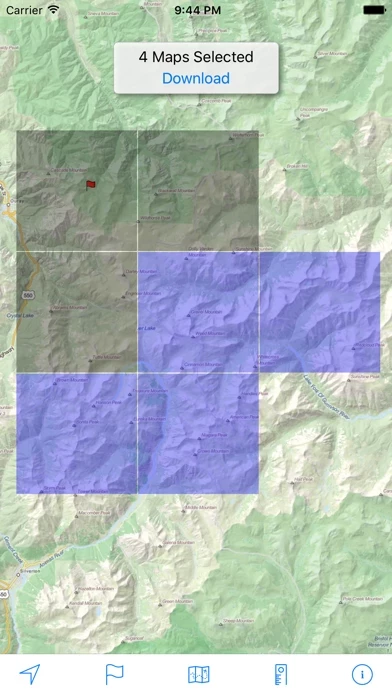
- Doesn’t require a user account to access the publicly available topo and imagery base maps. Just download before you go, then turn off Map Management to hide the download maps interface.
- Allows you to save the maps for offline use which is the cure function all such map apps should have but in reality many others do not. Let’s be realistic, when you’re in the mountains you won’t have cell service and this developer gets it.
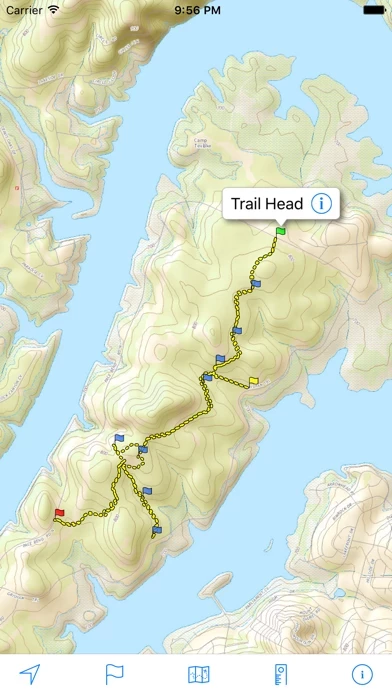
- Can trace your route, drop flags, and categorize and hide them to reduce map clutter.
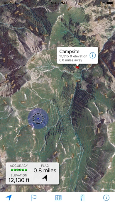
- Can get your GPS location instantly (new awesome feature, and useful for emergencies)!
- Uses little battery when tracing and less when not tracing. I was seeing ~10-15% for a half day of hiking on an iPhone 8. (If you are seeing high battery drain, it’s not TopoMapsUS. It’s probably your other background apps refreshing. Turn off background app refresh for useless apps, or toggle low battery mode to disable it globally and you’ll see that TopoMapsUS uses minimal battery. Also, use airplane mode If you’re not in a service area.)
- Map export is reasonably easy: send via email, or bulk export via a simple freeware, no-install WebDAV program.


By


Get it

Great basic navigation app. It has all the features you actually need and, most importantly, it’s simple to use. When you’re out in the field you don’t want a complicated interface with a bunch of social or otherwise needless features. I’ve used it as an NPS backcountry ranger if that counts for anything! I’ve also tried some other more featured and costly apps and this one will suit your purposes, especially if you come from a basic map and compass background.


By


Unbelievable

It is amazing that an app like this is available free of charge.

Not only are the maps perfect for hiking, very clear, very readable, but you can flag your hike by importing the location from your photos.

It would be plenty just to be able to use and orient yourself with these maps downloaded with the aid of a compass. But, when you add live gps locating, the photo location import feature, throw in the location of popular trails and sights, it better than most portable hiking gps units that cost $400 or more.

It’s all you need to navigate. I don’t carry the Earthmate PN 40 anymore. If you’re smart, you’ll save the $400 on buying such a unit and save weight on your hikes.

TopoMapsUS should have at least a tipping section because the developer deserves to be paid for it.

Consider all the other apps that require a subscription to download maps.

This is an awesome achievement,


By


USGS and University Approved!!

As a team of geologists from the USGS and a State University who have used TopoMapsUS extensively for field work, TopoMapsUS is officially amazing! Doing field work in the back roads near Yellowstone, TopoMapsUS was invaluable. We used it for navigation, correlation to geologic maps, and even to mark the location of our vehicle before long hikes into the back country. Thoroughly impressed, 5/5. The only thing that would be handy is a data sync option in which you can actively sync waypoints between devices so everyone is on the same page.


By


So close!

TopoMapsUS runs incredibly well, however i hope there will be a feature added to be able to download maps while at the same time be able to view the ones I have already downloaded. I also hope that there will be a feature to “ select all “ maps a couple of times before staring the download process. Otherwise, I have recommending this to everyone, even when they haven’t even asked lol


By


Get this one first

I use this all the time for for camping, exploring and hiking. Works great. Recording track and waypoints, standard

But recently had to put up some signs around town. I used TopoMapsUS to mark each one. Then I used “cyber duck” to connect to the phone/app, and transfer the data to my Mac. Then used “db browser for SQLite” to get the data into excel. It worked pretty well.

I’d like to see: what quadrangle I’m in, and be able to download older USGS topo maps. I like using old maps to explore items that for whatever reason have been left off new maps such as petroglyphs, mines, etc. as new development has overtaken it. But this would just bonus and keep me from going into another app.

Some other apps have some pretty great bells and whistles (that I use). TopoMapsUS just gets the job done.


By


Good but frustrating

This free app has a lot of great things going for it. But then I get used to all the great things and want more. It drains my battery quickly when I try to record my route. It also suddenly drops routes that I am in the middle of recording. 2-3 miles into a recorded hike, and it will just stop recording and not save the route, even when the phone is plugged into a power brick.

It's great for seeing where you are and roughly measuring distances. And it's amazing for being free.


By


Just Amazing!!!

Have used this map for the last 6-7 years backpacking and has been a literal lifesaver multiple times finding my way around!! Placing a flag at your desired location makes it so easy to find your way back. And above all it’s free!!!! The multiple features are astounding. The details are so helpful. Highly recommend without any reservations.


By


Fantastic app for topo needs

Big props to the author of TopoMapsUS. I have never reviewed an app before but I felt compelled to comment. This is one of those rare apps that is functional, has no bloat, and is all supported by one dedicated author.
It’s simple to use and effective out in the backcountry after downloading maps. I love it and cannot recommend it enough if you don’t want an expensive subscription app.


By


Very useful in hiking

Used TopoMapsUS to confirm correct trailhead, check distance to junctions, and select correct turns at junctions.. trail breadcrumbs were entirely correct. Map interface a little frustrating to use so close to Canadian border, but with care was able to bring it up on trail while walking. Thanks for a useful product!


By


Great app. A couple of requests

This is the only free offline topo map app I’ve found and as such is great! Here are my top requests:
1. Ability to select all tiles in a region to download. 2. Ability to transfer tiles between devices. 3. Ability to text search for trails, labels, or flag names globally or within current map view area. 4. Background tile download.

Thanks for making a great app!


By


The only app I’ve ever been motivated to write a review for

I’ve had TopoMapsUS for years. My favorite and most reliable for mapping offline. Does exactly what I need it to do without any extra b.s. My go to when hiking or when driving off-road. Amazing TopoMapsUS is free with no ads. I would gladly pay for TopoMapsUS, I wish there was a way I could at least donate to the developer.


By


Request Addition of Time Stamps in GPX Export

This is an incredible app for hiking! However, it’s missing one key ingredient- time stamps in the GPX export. I would like to use your app during hikes and then upload GPX with time information to fitness tracking sites like Strava. At the moment the lack of time information in the GPX export is preventing this workflow. Any chance you would consider adding time information?


By


awesome app for going in the backcountry

TopoMapsUS is better than the ones i paid for. the map data are great quality, it has very easy management of offline maps, has vector trail overlays w/ lots of trails & waypoint data, and loads my own GPX files. What more could you ask for? Thanks a jillion to the developer.


By


Wonderful!!!!

I grew up on paper topo maps. I’d finally got tired of the dizzying 3d map app I was using and went looking for a topo map app. I tried the popular ones, I would have been willing to pay the expensive subscription, but the apps were so busy and fenced that I couldn’t even get to a map. I tried this one last. It’s everything I had dreamed a topo map could be!

- simple!!!
- offline maps (easy to get tiles)
- the map is the entire screen except for a tab bar which offers nifty tools.
- the maps have roads, trails, landmarks and those sweet beautiful contour lines! Perfect amount of info.
- free


By


Excellent app

Exactly what I was looking for. A simple, free GPS app with topo maps for hiking and backpacking. Has some existing trails but also easy to add any GPX trail you can find. I’m sure you can get more features in paid apps but this has everything I need. Thank you to the developer!


By


Best Topo App

LOVE this topo app. I’ve tried several, including Gaia, and this is definitely my favorite. It’s very easy to use, has good features, and the map detail and graphics are usually better than other apps. It’s saved me lots of time in the backcountry and keeps me “found.” Love it!


By


Good app just needs ability to download without app open

Just need to add the ability to download maps without TopoMapsUS open and in the background.


By


Works and Free

Does what it promises — lets you easily download Topo maps onto your phone. No frills but it gets the job done.

Our family wanted a map for a hike in an area where cell service is spotty. TopoMapsUS let us easily see where we were at all times


By


Best Topo maps

I was shopping for topographic maps app today, ready to shell out some $, so I tried 4 or 5 of them. To my surprise, the best app is free.

Just 2 things. Please add iPhone X support soon. Also, please log start and end time for each trail. Thank you for the fantastic app.


By


A great tool!

So far i am liking TopoMapsUS really well. It took me a bit to figure out some things - like down loading the map squares. But it seems to work well for looking at the map and seeing where you are.

One item about TopoMapsUS that i think is killer is the distance drawing facility. One selects the measure option and then draw lines on the map then you see how long that route is.

It doesn’t appear to do some other things one might expect, like track you route, but what it does it does well and i prefer that!


By


Must Have

I've been using TopoMapsUS for years and now that I have the hang of it, I never start a hike without the proper maps.

Excellent for determining your location, how much ground you've covered and how much further there is to go.


By


A Great App

Used for the first time on a week-long hiking trip. TopoMapsUS was a joy to use. Easy to download maps pre-trip for offline use. The downloaded maps are GPS enabled and the measuring tool helpful. A great adjunct to standard map and compass


By


Great app for quick reference

TopoMapsUS has been a great quick ref when on the trail. Works without signal when maps are downloaded in advance. Used in big bend and Guadalupe mountains. Doesn't replace a map and compass but nice companion


By


Awesome for a free app

I use this all the time when hiking and exploring. Great for determining your location and you can load tracks into it. I don’t use it for tracking routes much.


By


Excellent App (and completely free:)

This is a great app and I use it all the time at work and play. I do wish I could import my own maps and routes. Other than that, it’s perfect.


By


Multi function Map app

This works off line if you have downloaded maps. Draw on a map to get distances. Flags, save tracks, etc. FREE


By


Simple & Useful

Download USGS topos for offline use, easily mark, save and share POI’s and tracks, and it’s entirely free! Not only that, but the developer responds very quickly (and helpfully) to any questions.


By


Easy and free

The map downloading capabilities of TopoMapsUS rival many of other paid apps (like Pocket Earth)


Is Topo Maps US Safe?


Yes. Topo Maps US is very safe to use. This is based on our NLP (Natural language processing) analysis of over 168 User Reviews sourced from the Appstore and the appstore cumulative rating of 4.4/5 . Justuseapp Safety Score for Topo Maps US Is 63.9/100.


Is Topo Maps US Legit?


Yes. Topo Maps US is a totally legit app. This conclusion was arrived at by running over 168 Topo Maps US User Reviews through our NLP machine learning process to determine if users believe the app is legitimate or not. Based on this, Justuseapp Legitimacy Score for Topo Maps US Is 78.7/100..


Is Topo Maps US not working?


Topo Maps US works most of the time. If it is not working for you, we recommend you excersise some patience and retry later or Contact Support.


How was your experience with Topo Maps US? Post a Review

Leave a comment:


Alternatives