Topo Maps+ Reviews

Topo Maps+ Reviews

Published by on 2024-10-22

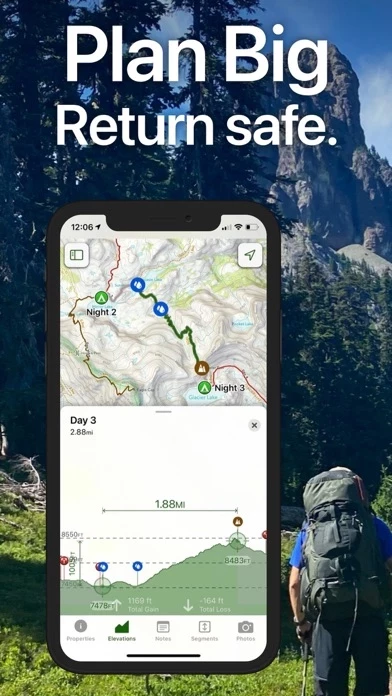
🏷️ About: Topo Maps+ is an app designed for backcountry adventurers, providing maps and tools for planning and executing outdoor activities. The app offers maps for every activity, planning tools, on-trail tools, and navigational mindset tips. It also has subscription levels, including a free level, Topo Maps+ Pro, and Topo Maps+ Hunt, and can be synced across all iOS and Mac devices.


Overall Customer Experience 😎


😎👌🔥 Positive experience
45.9%

👿🤬😠 Negative experience
39.4%

🙄💅🫥 Neutral
14.6%

~ from Justuseapp.com NLP analysis of 8,478 combined software reviews.


Summary of Customer Reviews (Takeaways): 💎

- Great mobile phone GPS app for hiking trails

- Maps are great and logging trails and marking waypoints are easy to do

- Accurate stats on distance, elevation, hiking duration, etc.

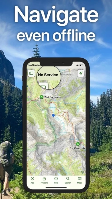
- Simple to download maps for offline use

- Intuitive and easy to use interface

- Clever tagging system for organizing waypoints and trails

- Good customer service and prompt support from developers

- Custom atlas at fingertips with downloaded maps

- Great for road trips, hiking, bicycling, and more


Read 23 Customer Service Reviews 👿🤬😡😠💢😤

4.8 out of 5

Can’t add new waypoints

2022-05-25

I feel like I’ve been duped. I purchased TopoMaps a couple years ago and paid to download the maps I need. Now TopoMaps is not allowing me to add new waypoints unless I upgrade to the pro version for $50 per year. This is a lot of money for a tour guide, yet all my precious waypoints that I need to do my job are in TopoMaps . What am I to do? I won’t upgrade TopoMaps, they will trick me again. When I purchased TopoMaps , I was never told the features I was paying for would be temporary. I no longer trust this company. I will not do business with them.. My other complaint is the lat/long coordinate formats. The degree symbol is not recognized when I manually add waypoints, so I have to convert them to decimal format which has been a real hassle in the future. Otherwise, until this recent software upgrade TopoMaps has worked great.

There are much better options for most

2022-06-26

I know TopoMaps has its fans but, unless you need something specific that’s unique to TopoMaps, there are much better choices. Unless you pay fifty dollars a year, or more, you’re limited to poor low resolution apps and most features are disabled. There are much better options for less money like the free and open source GPX Tracker or the amazing WorkOutDoors that’s subscription free, just five bucks one time, and completely shames Topo Maps+ with its Apple Watch support. Or GPS Tracks for less than half the price with most of the same maps. Gaia and AllTrails also shame Topo Maps+ in many ways. Topo Maps+ has very crude and limited Apple Watch support. It also wants access to a ton of personal information, requires you to open an account with more personal information, and links and collects more personal data than many similar apps. If your main goal is tracking/navigating hikes, walks, runs, and similar on trails or roads, and you have an Apple Watch, just get WorkOutDoors and you’ll have maps of the world that just work, and more easily accessible data than you can imagine, without paying any subscription fees. If you’re planning to go off trail you might want something more but even still you can likely save some money with one of the less expensive options. I cancelled my paid trial and have uninstalled TopoMaps as it’s just not worth paying for and the free version is basically worthless.

Maps are good, but UI is confusing and unnecessarily difficult to use

2022-07-27

The topo maps are good, especially the high res maps. However, the GUI of TopoMaps needs some cleanup. Everything feels about twice as complicated as it needs to be. During a hike, just accessing the distance traveled and elevation can sometimes be confusing because the view heirarchy is confusing. As another reviewer said, it’s difficult to figure iut if you’re actually using your purchased apps sometimes as well. There are tons of map choices for purchase, but in the end this mind of makes things more complicated for little gain.

Now one if my biggest gripes. Zooming in and out is awful! Pinching my fingers only seems to zoom the map like 10% of the time! I have to try over and over again just to zoom in or out, and it’s irritating and exhausting. Why?

TopoMaps has so much potential, and yet the GUI is just too confusing and zooming is unnecessarily obnoxious.

All good but the map downloading

2022-08-28

This is a great app with good selection of maps. My main reason for getting TopoMaps was for the offline map feature. I do a lot of exploring of logging roads, hiking trails, walking up streams and such so need maps viewable without cell signal. It works great...if you can get them to download. I was heading to the woods for a week and trying to grab the maps I wanted was one of the most frustrating things I have done in a while. TopoMaps crashes non-stop while trying to download. I zoomed way in to the smallest map quad to download and it crashes, tried one of the larger blocks of maps and it crashes. It will grab one map, maybe download 7 in a row then refuse any more and constantly crash. It closes TopoMaps and you have to start all ver finding the specific map to download. I have a newer iPhone and it’s current on updates, tons of free space and I’m on a fast WiFi connection. Doesn’t matter, crash, crash, crash!

Seriously annoying. Long ago I bought another app called Topo Maps and downloaded hundreds of maps with no issue. I stopped have it but that app has very outdated maps and not near the features of this app+ but dang to this day I can download any number of maps I want without my blood pressure rising!! Fix the downloading so I can give 5 stars!!!

Great App but needs improvement

2022-09-29

I have been using Topo maps+ for couple of years for backpacking and it works well in the backcountry. However, plotting routes is a pain. First of all, I don’t like the fact that it doesn’t have desk top application that can be used to plot routes and then import to TopoMaps . Also, TopoMaps doesn’t work well on the iPad - it’s super slow. Search function is not that great. When I am planning a hike and want to enter a search criteria to go to that map section, it doesn’t always take me to where I want to go means there are still a lot of places that are not entered? Also, when I plot a route using existing trails, cursor just stops if there is even a little gap in the trail on the map. Then I have to start a new route and then connect both later on which is a pain. I know I can use the freehand but freehand is not that accurate on mileages. I prefer using existing routes.

Big Bend gps works great without service

2022-10-30

Just got back from the mountains of west Texas. Really enjoyed my iphone (which is my gps, camera, and compass) running topi maps +. Before hiking I subscribed and was able to download the needed high resolution maps but at the check in point only had 1-2 bars of service—so took 1/2 hour for just 4 sections. but worked fine. Tracked my hikes with magenta color and kept me from getting lost or circling. However—WHAT does it mean when the blue locator ball has a ray beam? ALSO—what is that wagging tail pointer needed for (on the blue ball)since its not pointing to magnetic North? So i give TopoMaps a 4 because of the skimpy outback “manual”. Hey some of us are new at digital GPS apps! Otherwise its a bargain and can save time or even lives. Nice app overall.

Great app, even the free version

2022-12-01

I like pretty much everything, however the update that added all of the new waypoints overwrote some of my old waypoints that I already had saved on my maps, if possible could the old waypoints be added back in a future update? The old upside down teardrop had higher contrast with a dark bottom and lighter top that was much easier to distinguish if you had a few waypoints close together. And when importing it’d be great to have the option to change all of the waypoint icons at once, I may have just not seen the option to do that if it’s already there but it would be great to organize waypoints by each import from a kml file. But anyway, for a free hiking map app I’ve not seen any better ones available, I spend a lot of time in the woods at work and in my free time so TopoMaps has been invaluable to me

Spend some time with it before you head out

2023-01-01

I downloaded this for a trip to the Grand Tetons and Yellowstone. I went ahead and paid for the detailed maps of those parks as separate purchases. Once I got to the area, I couldn’t tell if I was using those maps. I finally realized that I wasn’t. I kept trying to download them, but iffy WiFi and cell signal in the park made it fail. I finally sent a note to support and got a reply from the founder of TopoMaps. I really can’t fault his follow up. He talked me through the maps icon showing the map you are using having a green border. The downloads have to continue until they say Open. At home this is no big deal, but on low bandwidth that download can sit in full green for a while before showing Open. I kept closing it too soon. Anyway, resolution is very good on those purchased maps and if you download them ahead of time, it is easy to use. With family sharing, others in the family can also download them. A friend that came with us got the subscription. This meant she had to download each map section. Again, better to do that before you leave stable WiFi. Only after I got home did I try my iPad. Looks great and we could have used that for planning the next days hikes over dinner. Without GPS, wifi only iPad won’t show location or path. But it is a nice big, high quality map for planning. So the interface could be easier, but it works as advertised and the founder Mr. Johnson has my thanks for reaching out to help, personally.

Topo+ made this year’s PCT hike a complete success.

2023-02-02

I was given responsibility for supporting several backpackers doing a SoCal section of the PCT. This involved daily travel to supply water and transport hikers to and from trail junctions and off trail camp sites. Without Topo+ this would have been impossible. Traveling the vast network of ATV trails was a success solely because I had Topo+ running as I was navigating. It proved a complete success in providing me with guidance on my own trail hiking too.

I have never used trail mapping software before - google maps meets my daily needs so I was amazed and relieved at how intuitive the Topo+ software is to use. And the emailed user advice proved perfect.

I recommend TopoMaps to everyone who wants an intuitive tool for planning and carrying out your travel adventures.

GREAT CUSTOMER SUPPORT

2023-03-06

I have been using TopoMaps for almost 2 years. I started with the free version, just tracking my horseback trail rides. Then I decided our favorite camp area had dozens of trails but no map to give other campers/riders. So, as a complete novice I took it upon myself to start building a map of all the areas horse/hiking trails. I don’t think Topo Maps+ was (originally) designed for the specific application, but the developers have really stepped up to help me accomplish this project. They are always quick to respond and very patient and helpful with my questions and the problems I encounter. They have also been very receptive to suggested updates that would help with my project, and ultimately be helpful with others using TopoMaps . Hopefully TopoMaps. will continue to grow and become even more robust and easy to use. Thanks

The Best Out There, So You Can Get Out There

2023-04-04

I’ve tried all the other backcountry mapping apps, and I always come back to this app+. The interface is easy to use, looks (and behaves) native, the free version is very usable, and my goodness, the number of power-user features is amazing. I’ve been intensely mapping trails and points of interest for the last several years in a mountain range, and I’m able to keep my hundreds of waypoints and trails organized and at-hand because of the clever tagging system. There are a lot of good maps, even without the pro subscription or map pass. And the other hiking oriented features work great too (I love “Progress on Trail”).

It’s saved my bacon several times when navigating off-trail in deep woods in the dark, so, thank you developers!

Exactly as advertised!

2023-05-06

I just returned from a week paddling in Quetico Provincial Park, a wilderness canoe area in Ontario, adjacent to the Boundary Waters in MN.
In the past, I've relied solely on a compass and map to navigate in Quetico, but this time I wanted a GPS backup (without buying an expensive GPS unit), i.e. a smartphone app.
I'd read some positive reviews of Topo Maps +, and contacted them with some questions. I ended up corresponding with Stephen Johnson, founder of Glacier Peak Studios.
He patiently walked me through the (simple and intuitive) set up, and guided me on how to download the maps I needed for Quetico into my smartphone, and explained how I could count on the phone's GPS capability even when I had no cell service or wifi in the bush.
Bottom line: five or six times last week, I opened TopoMaps (in Quetico, in the "middle of nowhere" with absolutely no cell or wifi service of any kind). Within 30 seconds or so, my phone was showing me EXACTLY where I was in high res detail (again, pinpointing my precise location on a particular lake, island, portage, etc.). Worked like a charm every time with no exceptions!
Cannot speak highly enough of TopoMaps or the support. If there were a six star rating, they'd get it from me!

A great tool for the prepared traveler.

2023-06-06

I use Topo Maps + before, during, and after every trip to parts unknown. By downloading maps of the areas I expect to visit beforehand, I have a custom atlas at my fingertips—no cell signal or wi-fi needed. During the trip, I often know better than my Google- or Apple-Maps-using companions where we are. By dropping pins, I can chart my progress, see where I’ve been, and recall where I was after I return home. Great for road trips as well as hiking, bicycling, and the like.
My only concern is that there doesn’t appear to be a way to export the data. As my iPhone 6 approaches end of useful life, I wonder how I’ll preserve the data. I should be able to migrate it to another device, but some sort of database export would be very welcome.

My compliments

2023-07-08

Added Note: developer response to App Store reviews is VERY prompt, and helpful.

A suggestion: provide a link to the help email address someplace in the MacOS app. Selecting MacOS Help shows: “Help isn’t available for Topo Maps.”

A comment: I’m happy with the costs. I’d much rather be the customer than the product.

Adding MacOS app to subscription: if you have a Pro subscription via the iPhone/iPad app and later download TopoMaps for MacOS, there evidently can be a delay between signing in and the subscription update. It can be a little confusing because routes, waypoints, etc. update right away leading you to suspect that something isn’t working right.

A few minor glitches, but...
What a great app! Detailed maps of trails excluded from other apps and maps. If one map doesn’t show the trail, another map will.

I love the trail planning capabilities. The snap-to-waypoint feature makes it exceptionally easy to plan a hike and get detailed information about it. Even if part of the hike is on, for example, a road and not a recognized trail, that portion can easily be added using freehand route tracing. Just fantastic.

Go to tool for serious hiking

2023-08-08

My wife and I have used this app (pro version) for the last 3 + years and although we have some other hiking/trail apps tools that we use also, this app is our go to mapping/hiking tool for our serious backcountry hikes. One of the greatest things about this app is the very prompt support I get from Stephen and/or Danny when I have problems...or just questions. They are VERY good at getting back to me in a timely manner and explain things in terms I can understand. Yes, there are glitches with TopoMaps on occasions but there are with any app. It seems like they do their very best to provide the proper updates to fix the glitches as quickly as possible. Keep up the good work guys and thanks for a great product. Marty

Hiking in New Hampshire

2023-09-09

This is an amazing app! Not only does it do everything I wanted and more, but their user support responded quickly and personally to help me figure out what I’m slow to learn.
I hike regularly in NH, always using a GPS. I purchased the Pro version of Topo Maps + hoping I could leave my stand-alone GPS at home and instead use TopoMaps to find my way. I did a trial hike using both (stand-alone and iPhone app) and was surprised to find Topo Maps + superior in every way! The screen is bigger and easier to use (zoom or look ahead), the map has more detail, and the resulting track is more accurate. Wow. Bye bye stand-alone GPS!

Great!

2023-10-11

Free version has Offline Downloadable map chunks, decent resolution, and RELIABLE. GPS location compatible. I download the map chunks and use them with google earth when planning my 3-7 day hikes in "real" wilderness with only animal trails and forest service roads. I can use it for alternative routes (paths of least resistance) and emergency locations for rescue and water refill. ALWAYS share your path, and points of interest throughly with someone else, and be realistic. I can hike 4 MPH on clear roads and trails for 12 hours a day... But in the wild your paths are not straight, and the going is not that easy. For safety, I plan for 2 miles a day, and use the rest of the time for food, camp, and water. I don't want anyone fired from their job, hurt, lost, or freaking out wondering about the unknown if something were to happen to me. I'm a professional, and this a a simplified review. If you are confident, you are going to fail. Plan better. This tool helps.

Topo Maps is great

2023-11-11

I used another apps for hiking trails prior using Topo Maps. Topo Maps has been great a mobile phone GPS apps. The maps are great. Logging trails and marking waypoints are easy to do. The stats on distance, elevation, hiking duration, etc, are great features and are pretty accurate. Maps download is simple to do. This apps has all the features that I need to track and record my trails. Although I have a GPS, I have been using this apps instead of my GPS. Once I downloaded the maps I need, I can use them offline which is an important feature to me. When I need to reinstall the apps due to phone issue, I don’t lose my recorded tracks which is a big plus. The apps is dependable and has all the features I like to have for my needs. When you have questions regarding the apps, you get response back promptly which I really appreciate. Great apps to use for trails for my needs. Thanks for developed a great GPS apps for mobile phone.

My favorite app

2023-12-13

I’ve never written a review before but TopoMaps has compelled me. It functions absolutely flawlessly from my phone with no need to sync with computers and all the headache that comes with a GPS unit. The maps have proved to be accurate and the ability to overlay the Topo and satellite is incredibly useful. When I’m out hiking I put the phone in the airplane mode. And only use about 30 to 40% of the battery in a entire day of hiking and navigation. With a small external battery pack in the same pocket of my backpack as my phone I can easily go for five days of navigating as long as I’m not continuing to room for cell service or playing games at night.

Very pleased

2024-01-13

This will be my third year using Topo Maps+. I used the free version on a nine-day backpacking trip the first year and it worked fine. I’ve upgraded for the last two years, appreciating the extra detail and features given that much of our backpack trips are off trail. It’s fun to play with the maps ahead of the trip to see distances and elevation gains for different routes. I take a small charging block just in case, but even over 10-day trips, judicious use of the iPhone allowed us to refer to the maps whenever needed without power issues. I have been particularly impressed by the customer service the couple of times I have had questions. Responses have been prompt and very helpful.

Love This App!!

2025-01-15

Planned more hikes than we had days for in Rocky Mountain National Park for the second week of June not knowing exactly what kind of snow we'd find on the trails. Topo Maps+ was a blessing when the snow obliterated the trails. In addition, the Progress on Trail function is amazing fo those long hikes. It lets you know where you are and how much longer you have to go to the next waypoint or till the end.

Furthermore,the manager, Danny Scott, is a treasure. I love the emails with tips and suggestions and when I had a question about a particular feature he was on it right away.

Thank you for an App that works and continues to grow and develop. Cheers!!

Not much to say beyond fantastic.

2025-01-15

I have been using TopoMaps for almost two years now and have used it in the USA from coast to coast Hawaii and even in Guam.
It has never failed to get me information I need to make it to the trailhead and into the backcountry.
There is sometimes a little learning curve to pick the right map city, suburbs or backcountry, but once I’ve made a decision I have never Ben disappointed.
I have used TopoMaps on Three of New Zealand’s Great walks and several day hikes just inside and out of Aukland.

And just recently used it just for grins at the Great Wall outside of Beijing, don’t need a map to follow the Great Wall. My only issue there was lack of gps coverage even with a bad elf plugged into my iPhone 7 Plus.
Keep playing with the map because every time I do, I seem to find something else that's new.

I’m a tried and true paper map hiker but love TopoMaps for the holes in paper map coverage or route changes in my wanderings.
Can’t wait to try out the new US Natural Map.

Great app, involved developer!

2025-01-15

There are a lot of mapping apps out there, and this is definitely one of the best. The mobile app is well-designed by someone who actually spends time in the backcountry, and tight integration with a full-featured desktop app is awesome. Most importantly, the developer Stephen Johnson is highly responsive to user comments & feature suggestions--a couple features I suggested were quickly added to TopoMaps in updates--outstanding! $50/year for full access to all high-res maps is totally reasonable, and the recent update to V5 is a big improvement. Thanks Stephen!


Is Topo Maps Safe? 🤗🙏


Yes. Topo Maps+ is very safe to use. This is based on our NLP (Natural language processing) analysis of over 8,478 User Reviews sourced from the Appstore and the appstore cumulative rating of 4.8/5 . Justuseapp Safety Score for Topo Maps Is 53.8/100.


Is Topo Maps Legit? 💯


Yes. Topo Maps+ is a totally legit app. This conclusion was arrived at by running over 8,478 Topo Maps+ User Reviews through our NLP machine learning process to determine if users believe the app is legitimate or not. Based on this, Justuseapp Legitimacy Score for Topo Maps Is 70.9/100..


Is Topo Maps+ not working? 🚨


Topo Maps+ works most of the time. If it is not working for you, we recommend you excersise some patience and retry later or Contact Support.


Payments 💸🤑💰

**Pricing data is based on average subscription prices reported by Justuseapp.com users..

Pricing Plans Amount (USD)
Topo Maps+ Pro $49.99
12 Month Map Pass $19.99
Topo Maps+ Elite $69.99
3 Month Map Pass $11.99
Topo Maps+ Essentials $24.99
Topo Maps+ Pro: 3 Months $24.99
12 Months PRO $59.99
Topo Maps+ Essentials 3 Months $14.99
3 Months PRO $29.99
6 Month Map Pass $14.99


How was your experience with Topo Maps+? Post a Review


Features

- Maps for every activity, with the ability to set up maps based on planned activity

- Planning tools, including the ability to compare and download maps for offline use, combine overlays, use smart route-building tools, add waypoints, and print, email, or share custom maps and routes

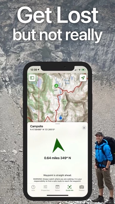
- On-trail tools for offline use, such as viewing current location, recording tracks, receiving proximity alerts, using line of sight, tracking progress on the trail, and downloading elevation data for route-creation

- Navigational mindset tips for staying safe in the backcountry

- Subscription levels, including a free level, Topo Maps+ Pro, and Topo Maps+ Hunt, with varying features such as high resolution maps, MapBox Satellite map, US public and private land overlays, parcel and ownership contact info, and game management units

- Apple Watch compatibility for viewing offline maps and current location

- Cloud syncing for routes, trips, subscriptions, and waypoints across all iOS and Mac devices

- Subscription payment information, with automatic renewal unless canceled at least 24 hours before the end of the free trial or current period

- Privacy Policy and Terms of Service links provided

- Note that continued use of GPS running in the background can decrease battery life.

  Customer Service/Support
Developer:
Glacier Peak Studios LLC

Contact e-Mail:

Website:

Privacy Policy: