Earthquake - alerts and map Software
Company Name: Nico Tranquilli
About: Earthquake Sound is a manufacturer of high-end home, mobile audio products.
Headquarters: Hayward, California, United States.
Earthquake Overview
What is Earthquake?
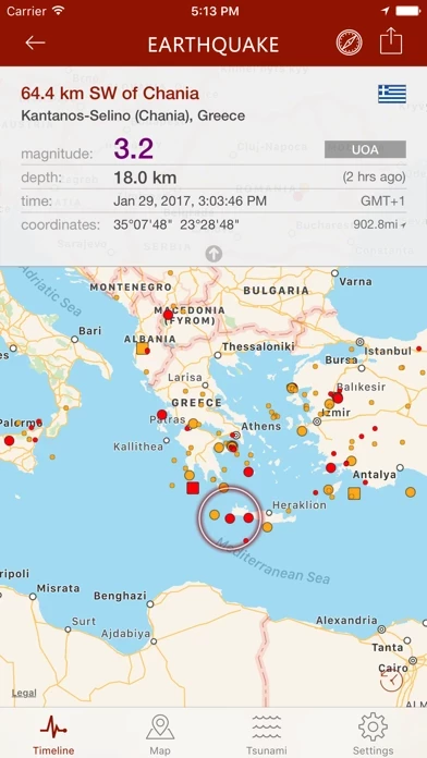
The Earthquake app is a popular iOS app that has been downloaded over 3 million times and is compatible with iPhone, iPad, and Apple Watch. The app provides the latest worldwide earthquake data from multiple sources, including USGS, EMSC, GeoScience Australia, and more. Users can set up to four push notification alerts based on location and/or magnitude threshold, view earthquake data on a map with different sized and colored circles, filter events by area or magnitude, and access earthquake catalogs and tsunami bulletins. The app also offers social sharing, reverse geocoding, and widget support, among other features. It is available in multiple languages and supports Siri Shortcuts, Critical Alerts, and Dark Mode.
Features
- Supports Apple Watch and provides the latest worldwide data from several sources.
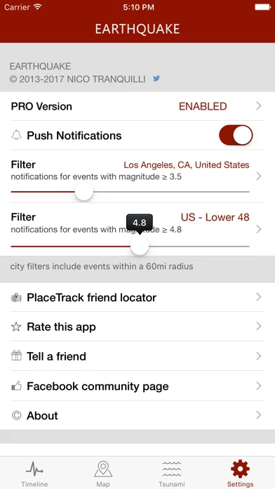
- Rich push notifications on your phone as soon as the event data is available from an official source. You can set up to 4 alerts based on location and/or magnitude threshold.
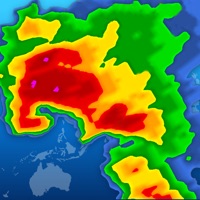
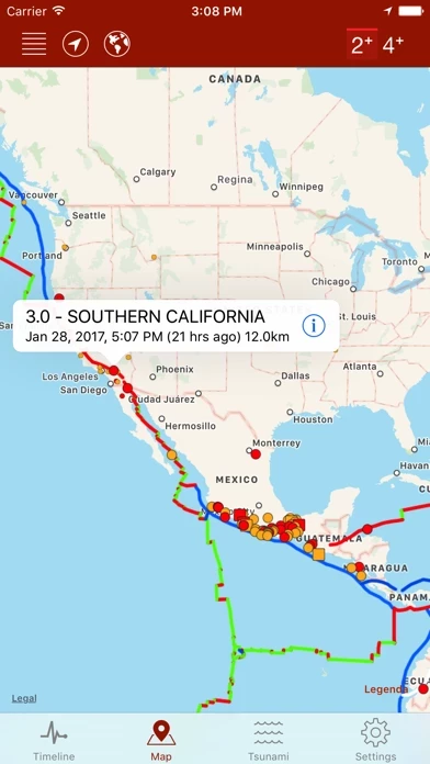
- Map with different sized and colored circles to represent event magnitude and age.
- Filter events by area (country, continent) or magnitude.
- Multiple sources, including U.S. Geological Survey (USGS), European-Mediterranean Seismological Centre (EMSC), GeoScience Australia, GNS Science (GeoNet), Instituto Geográfico Nacional, Servicio Sismológico Nacional, British Geological Survey, GFZ GEOFON, Natural Resources Canada, NOAA.
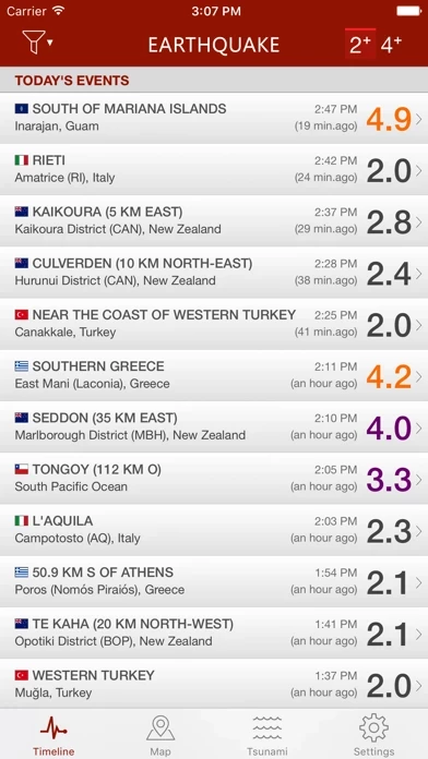
- Event timeline (today, yesterday, previous days).
- Earthquakes catalog (all world regions covered, back to 2013), search by date, territory, city or reporting agency.
- Detail view for each event, reachable from map and timeline views.
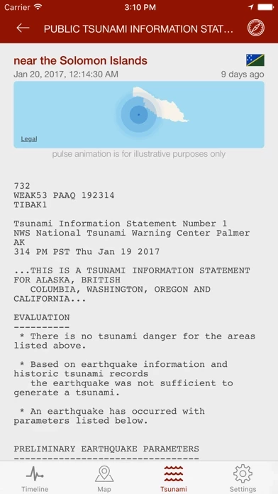
- Tsunami bulletins (NOAA data).
- Tectonic Plate Boundaries (USGS data).
- Population estimates for each event and Population Density layer (SEDAC/NASA data).
- Export data to Google Earth or other installed apps supporting kml file format.
- Social sharing: share event map and data to Facebook, Twitter, Email.
- Reverse geocoding: names of locations, when unavailable, are calculated automatically from their geographical coordinates.
- Widget: the widget briefly shows some details of the biggest seismic event that occurred in your country over the last 24 hours.
- 3D Touch and Haptic feedback support.
- Siri Shortcuts support - "Hey Siri, what are the latest earthquakes in the United States?"
- "Critical Alerts" and "Dark Mode" support.
- Earthquake catalog search by date, city, country, continent and reporting agency.
- Multiple languages: the app is localized in English, Spanish, French, German, Italian, Greek, Russian, Chinese, Dutch, Portuguese, Turkish, Hungarian, Romanian, Korean, Croatian.
Official Screenshots
Product Details and Description of
#1 this app app for iPhone and iPad, more than 3M downloads, supports Apple Watch. Get the latest worldwide data from several sources and receive push notifications alerts. Main features: • rich push notifications on your phone as soon as the event data is available from an official source (you can set up to 4 alerts based on location and/or magnitude threshold) • map with different sized and colored circles to represent event magnitude and age • filter events by area (country, continent) or magnitude • multiple sources, including U.S. Geological Survey (USGS), European-Mediterranean Seismological Centre (EMSC), GeoScience Australia, GNS Science (GeoNet), Instituto Geográfico Nacional, Servicio Sismológico Nacional, British Geological Survey, GFZ GEOFON, Natural Resources Canada, NOAA • event timeline (today, yesterday, previous days) • earthquakes catalog (all world regions covered, back to 2013), search by date, territory, city or reporting agency • detail view for each event, reachable from map and timeline views • Tsunami bulletins (NOAA data) • Tectonic Plate Boundaries (USGS data) • Population estimates for each event and Population Density layer (SEDAC/NASA data) • export data to Google Earth or other installed apps supporting kml file format • social sharing: share event map and data to Facebook, Twitter, Email • reverse geocoding: names of locations, when unavailable, are calculated automatically from their geographical coordinates • Widget: the widget briefly shows some details of the biggest seismic event that occurred in your country over the last 24 hours. • 3D Touch and Haptic feedback support • Siri Shortcuts support - "Hey Siri, what are the latest earthquakes in the United States?" • "Critical Alerts" and "Dark Mode" support • this app catalog search by date, city, country, continent and reporting agency • multiple languages: the app is localized in English, Spanish, French, German, Italian, Greek, Russian, Chinese, Dutch, Portuguese, Turkish, Hungarian, Romanian, Korean, Croatian
Top Reviews
By Tpauzen in Denver
The app is outstanding,
The app that you get in the basic package works great as long as you are ok with minor earthquakes 6.6 and below on the Standard scale. This is pretty much all I need it for. We don't get anything larger in magnitude here in Colorado, Wyoming, Oklahoma, New Mexico, Kansas, and Utah‼️🙏🏼❤️😃❤️🙏🏼‼️ If we do, I live close enough to the NSGS in Golden Colorado to make the local phone call to find out what happened‼️🙏🏼❤️😃😍😁🙏🏼‼️ If you want to follow the New Madrid or the San Andreas faults where the "big ones" are predicted, you can't go wrong buying the upgrade packages‼️🙏🏼❤️😃💬🙏🏼‼️ I'm a retired teacher so cost is a factor, but the app programmer did a great job for what I need‼️🙏🏼😃🙏🏼‼️ GOD BLESS AND BE EXCELLENT‼️🙏🏼😃🙏🏼‼️
By Mtn gardener 451
Always accurate
I first started using this app when I moved to California and started noticing the pictures on the walls of the condo were constantly out of level. I figured it would be cool to know just how often we were experiencing earthquakes. I’ve since moved out of California but like knowing when quakes occur around the globe. The alerts always pop up before I read about the quakes on the news. It would be great if everyone’s phone was linked into the system to give data about local quakes as I’m sure a cellphone could detect such events if it’s left resting on a nightstand.
By AlaskanJ
Accurate timely information
I’ve had this for about 2years now, I live in south central Alaska with very active seismic activity locally and on a daily basis statewide. The speed and accuracy is pretty much spot on to what makes the headlines, (same source I’m sure). Very nice because it covers worldwide as well and can have the notifications settings specific to a region. Highly recommend to keep up to date with seismic activities.