komoot Overview
What is komoot? Komoot is an app that helps users plan and navigate outdoor adventures such as hiking, mountain biking, and road cycling. It provides detailed information on routes, including surface, difficulty, distance, and elevation profile. The app also offers turn-by-turn voice navigation, offline maps, and a community-driven feature called Highlights, which showcases popular destinations and points of interest. Users can track their adventures with GPS, add photos and tips, and share their experiences with the komoot community. The app is available for free, with the option to purchase additional regions or a World Pack for offline maps and navigation.
Features
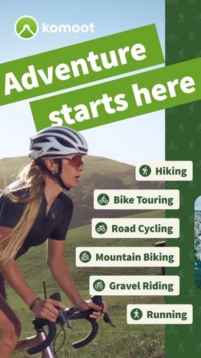
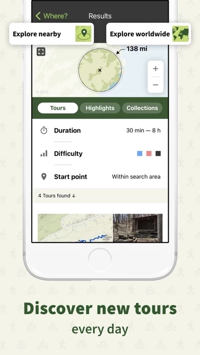
- Route planner for hiking, mountain biking, and road cycling
- Detailed information on routes, including surface, difficulty, distance, and elevation profile
- Turn-by-turn voice navigation
- Offline maps for outdoor adventures
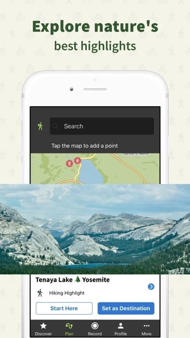
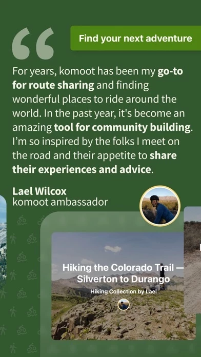
- Highlights feature showcasing popular destinations and points of interest
- GPS tracking with the ability to add photos and tips
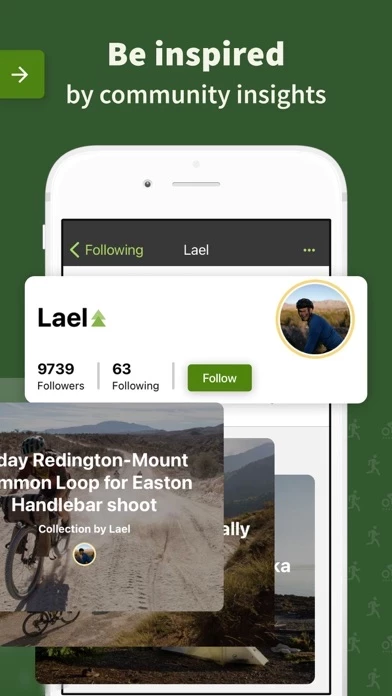
- Community-driven platform for sharing experiences and recommendations
- Local Expert and Pioneer features for contributing to the community
- Seamless sync across devices, including smartphones, desktops, and Apple Watch
- Integration with Garmin and Wahoo devices
- Free download with the option to purchase additional regions or a World Pack
- Integration with Apple Health for tracking activity data.
Official Screenshots
Product Details and Description of
Turn your next ride, hike, or run into an adventure with this app. Get inspired by tapping into shared community knowledge and recommendations, then bring your adventures to life with the easy route planner. PLAN YOUR PERFECT HIKING, MOUNTAIN BIKING OR ROAD CYCLING ADVENTURE Get the route perfect for your sport—be it smooth asphalt for your road bike, singletracks for your mountain bike, silent cycling paths for touring or natural trails for your hikes. Plan down to the last detail with at-your-fingertips info like surface, difficulty, distance and elevation profile. TURN-BY-TURN VOICE NAVIGATION Never take your eyes off the road with turn-by-turn voice navigation: your precise, down-to-the-inch verbal navigator that doesn’t distract you from your surroundings. Keep your eyes firmly on the adventure in front of you and navigate with ease, even on small trails or in the woods. OFFLINE MAPS FOR OUTDOOR ADVENTURES Download your planned outdoor adventures and save topographic maps with one tap. Navigate the outdoors even when the internet is down or unreliable. Differentiate hiking paths, MTB singletracks or paved roads, terrain and land cover at a glance. BROWSE HIGHLIGHTS: THE this app COMMUNITY’S FAVOURITE PLACES So you can decide on the destination of your next adventure at a glance, see Highlights on the map. From peaks, parks, and points of interest, to singletracks and sandwich shops, these places or segments, showing up as red dots in the planner, are the spots other users think you should check out. And if you’re in the know, you can recommend your own to the community in turn and inspire others to visit your favourite places, too. TELL YOUR STORY Track your rides and hikes with GPS. Add photos, Highlights and tips and build your own personal adventure log that’ll store your favourite experiences—forever. Save them for private use or share them with the this app community to receive likes and comments and to inspire fellow outdoor folks. Follow your friends and like-minded explorers to keep up with their outdoor adventures. BE A LOCAL EXPERT. BECOME A PIONEER. Contribute photos, tips and Highlights to the community and show you’re a local Expert. Earn more upvotes than in any else for your sport in your region and become the Pioneer! SEAMLESS SYNC ACROSS EVERY DEVICE Whether you prep like a pro on your desktop or plan a route on the go, this app automatically syncs your routes, tracked adventures and photos across all devices, including your smartphone, desktop, iPad and Apple Watch. Use a Garmin or a Wahoo? Simply download the this app for Garmin app in the IQ Store and sync your profiles via Garmin Connect, or connect your this app and Wahoo accounts to share Tours with the ELEMNT and ELEMNT BOLT. EXPERIENCE this app FOR FREE When you download this app, your first region is free—forever. To expand the areas in which this app has your back, conveniently choose between single regions, region bundles or the World Pack to access offline maps and turn-by-turn voice navigation wherever you go. APPLE WATCH Take a quick glance at your Apple Watch to get directions, distance, and speed in real-time—right on your wrist. APPLE HEALTH You can connect this app to Health to ensure your data is always up-to-date. Automatically share your time and distance data for this app hiking, cycling, and running activities with Health. “this app does for hiking and biking what Apple does for hardware: makes it easily accessible and fun to use.” — Cult of Mac For support and tips, please visit help.this app.de MORE INFORMATION this app uses background audio service for voice navigation messages. this app requires a GPS signal for directions, Tour recording and speed in real-time. Terms of Use: https://www.apple.com/legal/internet-services/itunes/dev/stdeula/
Top Reviews
By ut bike rider
Perfect for bike touring
Pros: it works well. The reason I downloaded is for its voice navigation along a user defined route ... the only app I’ve found that does so without an annual subscription. Most can only navigate a route it calculates. The mapping tool online works well and is easy to use. Save a created route and it automatically becomes available in the mobile app. Routes created elsewhere can be imported and edited. Cons: when importing a gpx route, it can get altered by this app if the route goes someplace not on Open Street Maps, which this app uses. The good news is you can edit Open Street maps yourself to correct the map. Nitpicking: voice navigation below a mile is given in feet instead of tenths of a mile. Example: 3900 feet instead of .8 miles.
By citrussqueeze
Love the app!
Pros- the app makes it very easy to plan rides. I like that I can see the miles and elevation gains before I leave my house. It’s nice knowing what I’m getting into for the trip. I also like that I can download the maps after I plan the ride. You can still use the gps directions even when you don’t have service. Cons- it can be tricky out figuring out how to plan your trips. There are a lot of options so it can be a bit cumbersome finding what you need. Easy to navigate once you figure it out though. Also they do charge you per area after your first download. But it’s worth the it!
By doc2b88
Very good Mountainbike navigation app! Highly recommended!!!
I ´ve tried many apps for creating individual Mountainbike routes at home and use the navigation system offline because of the lack of connection in the Austrian Mountains and mostly got disappointed . But this app fulfills all my criterias for guidet Mountainbike fun. Even if I take a wrong turn in the woods ,it finds an alternative track to guide me safely to my chosen destination! I am glad i found this app! It is soo much more fun to ride the mountains without having fear to get possibly lost or head all the way back uphill if you took the wrong turn. Thank you this app !!!