Map Plus Software
Company Name: Miocool Inc.
About: Easiest way to discover fitness destinations & Stay fit
Headquarters: Pune, Maharashtra, India.
Map Plus Overview
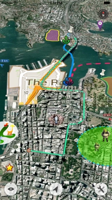
What is Map Plus? Map Plus is a powerful and versatile tool for viewing and editing custom maps, surveying, editing, or managing mass of your geography or travel data. It can be used as a professional GIS tool for geographic data gathering, editing, measuring, cartography, surveying, planning, online/offline viewing, and many other management. It can also be used to help your outdoor activities and global travels, for trip planning, offline map downloading, track/photo/video recording, or sharing memories with friends.
Features
- Supports importing, viewing and downloading thousands of custom online maps, such as OSM, GoogleMap, BingMap, USGS, or any WMS/WMTS map services.
- Supports importing offline map files such as MBTiles.
- Supports both EPSG:4326 and Web Mercator (EPSG:3857) for raster maps; Supports offset maps using China GCJ-02 datum.
- Importing and exporting KML/KMZ files with full styles, extended data and "gx" extension support.
- Importing and exporting GIS vector files, such as SHP, TAB, GEOJSON, GML/GZ with all EPSG projections/CRS. (using GDAL)
- Importing/Exporting AutoCAD DXF files with blocks, mtext, xdata and affine transformation support for coordinates mapping.
- Importing files of CSV, GDB, MPS, WPT, EVT, PLT, PNT, RTE, etc.
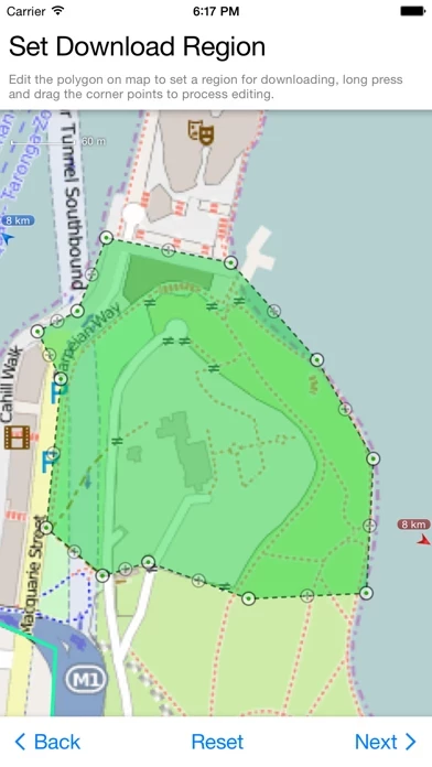
- On-map Editing with Drag-Drop and Magnetic Snap support for all places, tracks, lines, polygons, circles, rectangles, text overlays, etc.
- GPS Track Recording with auto-recovery, custom time zone and background mode support.
- Path Following with voice guidance for own lines/tracks or searched out direction routes.
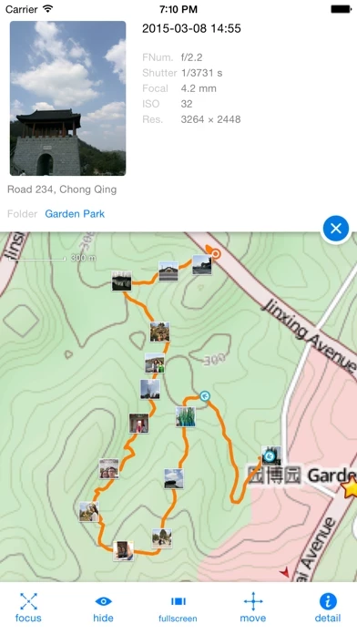
- Displaying photos and videos on the map based on locations.
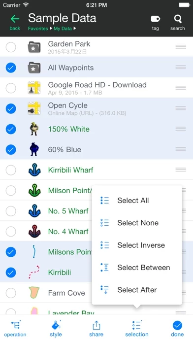
- Managing mass data with multi-level folders, layers, bulk operations, shortcuts, tags and fuzzy searches. Advanced Search supports expressions and property conditions.
- Using Feature Class for bulk editing and managing on similar (same kind) features and layers all together. Supports bulk Attributes Merge and Link Relationship Building between features of different classes.
- Conditional Style, Script Property and Expression provide dynamic content of rendering, attributes and text labels.
- Customizable pop-up panel for selecting items on the map with HTML, JS and CSS support to make your own forms, layout and rich-formatted content.
- Displaying coordinates in MGRS or UTM.
- Photo Markup enables you to add arrows, texts, shapes, icons and free-hand draws to a photo.
- Browser Access enables you to upload and view data from a web browser on PC/Mac within a Wi-Fi network, or play slideshow on your TV for travel photos.
- Sharing or transferring data via Wi-Fi, Bluetooth, iCloud, SMS, Email, QR codes, Open-In, AirDrop or many other ways.
- Backup & Restore function helps you backup/restore data to/from files or iCloud easily.
- Many more fantastic and free functions could not be fully listed here, such as Guide Mark, Arrival Notification, Photo Mode, Map Level Adjust, Custom Icons, Photo/Video Attachments, Image Overlay, Text Overlay, Fast Editing, Distance/Perimeter/Area Measuring, Custom Time Zone, etc.
Official Screenshots

Product Details and Description of
The most powerful and versatile tool for viewing and editing custom maps, surveying, editing or managing mass of your geography or travel data. ● You can use Map Plus as a professional GIS tool for geographic data gathering, editing, measuring, cartography, surveying, planning, online/offline viewing and many other management. ● You can also use Map Plus to help your outdoor activities and global travels, for trip planning, offline map downloading, track/photo/video recording, or sharing memories with friends. Besides common map features such as locating, searching, Map Plus has many more special: ● Supports importing, viewing and downloading thousands of custom online maps, such as OSM, GoogleMap, BingMap, USGS, or any WMS/WMTS map services. Both XYZ pattern and Javascript could be used to define maps. ● Supports importing offline map files such as MBTiles. ● Supports both EPSG:4326 and Web Mercator (EPSG:3857) for raster maps; Supports offset maps using China GCJ-02 datum. ● Importing and exporting KML/KMZ files with full styles, extended data and "gx" extension support. ● Importing and exporting GIS vector files, such as SHP, TAB, GEOJSON, GML/GZ with all EPSG projections/CRS. (using GDAL) ● Importing/Exporting AutoCAD DXF files with blocks, mtext, xdata and affine transformation support for coordinates mapping. ● Importing files of CSV, GDB, MPS, WPT, EVT, PLT, PNT, RTE, etc. ● On-map Editing with Drag-Drop and Magnetic Snap support for all places, tracks, lines, polygons, circles, rectangles, text overlays, etc. ● GPS Track Recording with auto-recovery, custom time zone and background mode support. ● Path Following with voice guidance for own lines/tracks or searched out direction routes. ● Displaying photos and videos on the map based on locations. ● Managing mass data with multi-level folders, layers, bulk operations, shortcuts, tags and fuzzy searches. Advanced Search supports expressions and property conditions. ● Using Feature Class for bulk editing and managing on similar (same kind) features and layers all together. Supports bulk Attributes Merge and Link Relationship Building between features of different classes. ● Conditional Style, Script Property and Expression provide dynamic content of rendering, attributes and text labels. ● Customizable pop-up panel for selecting items on the map with HTML, JS and CSS support to make your own forms, layout and rich-formatted content. ● Displaying coordinates in MGRS or UTM. ● Photo Markup enables you to add arrows, texts, shapes, icons and free-hand draws to a photo. ● Browser Access enables you to upload and view data from a web browser on PC/Mac within a Wi-Fi network, or play slideshow on your TV for travel photos. ● Sharing or transferring data via Wi-Fi, Bluetooth, iCloud, SMS, Email, QR codes, Open-In, AirDrop or many other ways. ● Backup & Restore function helps you backup/restore data to/from files or iCloud easily. ● Many more fantastic and free functions could not be fully listed here, such as Guide Mark, Arrival Notification, Photo Mode, Map Level Adjust, Custom Icons, Photo/Video Attachments, Image Overlay, Text Overlay, Fast Editing, Distance/Perimeter/Area Measuring, Custom Time Zone, etc. User Manual: http://duweis.com/en/mapplus_guide.html User Forum: http://duweis.com/forums/viewforum.php?f=13 Contact Us: [email protected]
Top Reviews
By BruntonMaster
Happy Geologist
I use this app principally to view georeferenced maps while out mapping in the field and can easily overlay Topo and geo maps, and while using my built in GPS unit on my IPad can precisely locate myself. Overall a great map for dropping pin locations and attach photos such that they are GPS referenced. However, my only complaint is the line drawing functionality. If developers could add a line drawing function that is more organic, such as using your finger to draw the line, that’d be a great add. If better line drawing functionality would be incorporated, it would make it such a great mapping app. As it stands, it is a great tool if you have referenced maps to use in the field or trying to plan transects without lugging around numerous paper maps.
By BigCornice
By far, the most advanced iOS mapping app.
For basic use this app works fairly well right out of the box. It includes a nice feature that reads the tags from your photos and plots them on your map. Where this app really shines though is in its more advanced features. It allows for layering of online maps and downloaded MBTiles while supporting various projections. GPX and shapefile layers are easy to add as well. It’s layering and drawing capabilities are more like a desktop app like QGIS than a mobile app. Nothing seems to be as powerful and stable. Out of the box Gaia has more maps available and its features are more accessible. However, if you need more control and have your own data sources this incredible app from China can’t be beat.
By Captn Ryan
Great app but takes some time to learn the interface
I was looking for an off line version of google maps that I could still draw on while off line. This app does it all. I use this for hinting and hiking. I love the fact that you ca also track your route as you go which is a bonus as google can’t do it. Their “no network needed” file transfer from phone to phone is great. Allow you to collaborate data collected without finding cell service first. The only upgrade I can think of would be to see your invited friends on the map when you have a data connection. Maybe establish the link when connecting wirelessly?