Map Plus Reviews

Map Plus Reviews

Published by on 2023-10-02

About: The most powerful and versatile tool for viewing and editing custom maps,
surveying, editing or managing mass of your geography or travel data. ● You
can use Map Plus as a professional GIS tool for geographic data gathering,
editing, measuring, cartography, surveying, planning, online/offline viewing and
many other management.


About Map Plus


What is Map Plus? Map Plus is a powerful and versatile tool for viewing and editing custom maps, surveying, editing, or managing mass of your geography or travel data. It can be used as a professional GIS tool for geographic data gathering, editing, measuring, cartography, surveying, planning, online/offline viewing, and many other management. It can also be used to help your outdoor activities and global travels, for trip planning, offline map downloading, track/photo/video recording, or sharing memories with friends.


Features


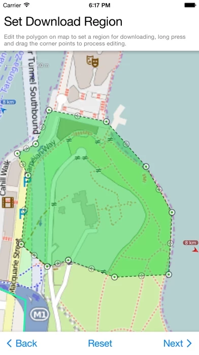
- Supports importing, viewing and downloading thousands of custom online maps, such as OSM, GoogleMap, BingMap, USGS, or any WMS/WMTS map services.

- Supports importing offline map files such as MBTiles.

- Supports both EPSG:4326 and Web Mercator (EPSG:3857) for raster maps; Supports offset maps using China GCJ-02 datum.

- Importing and exporting KML/KMZ files with full styles, extended data and "gx" extension support.

- Importing and exporting GIS vector files, such as SHP, TAB, GEOJSON, GML/GZ with all EPSG projections/CRS. (using GDAL)

- Importing/Exporting AutoCAD DXF files with blocks, mtext, xdata and affine transformation support for coordinates mapping.

- Importing files of CSV, GDB, MPS, WPT, EVT, PLT, PNT, RTE, etc.

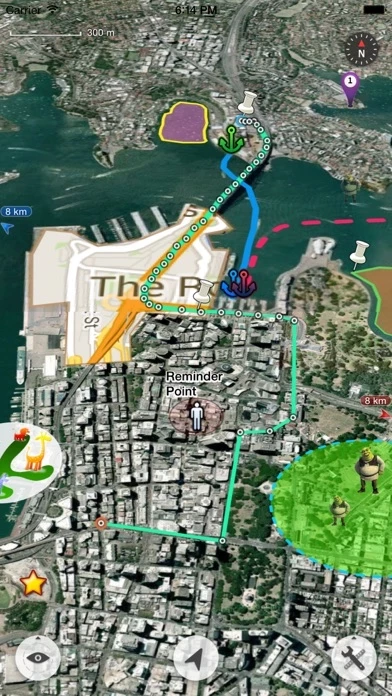
- On-map Editing with Drag-Drop and Magnetic Snap support for all places, tracks, lines, polygons, circles, rectangles, text overlays, etc.

- GPS Track Recording with auto-recovery, custom time zone and background mode support.

- Path Following with voice guidance for own lines/tracks or searched out direction routes.

- Displaying photos and videos on the map based on locations.

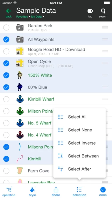
- Managing mass data with multi-level folders, layers, bulk operations, shortcuts, tags and fuzzy searches. Advanced Search supports expressions and property conditions.

- Using Feature Class for bulk editing and managing on similar (same kind) features and layers all together. Supports bulk Attributes Merge and Link Relationship Building between features of different classes.

- Conditional Style, Script Property and Expression provide dynamic content of rendering, attributes and text labels.

- Customizable pop-up panel for selecting items on the map with HTML, JS and CSS support to make your own forms, layout and rich-formatted content.

- Displaying coordinates in MGRS or UTM.

- Photo Markup enables you to add arrows, texts, shapes, icons and free-hand draws to a photo.

- Browser Access enables you to upload and view data from a web browser on PC/Mac within a Wi-Fi network, or play slideshow on your TV for travel photos.

- Sharing or transferring data via Wi-Fi, Bluetooth, iCloud, SMS, Email, QR codes, Open-In, AirDrop or many other ways.

- Backup & Restore function helps you backup/restore data to/from files or iCloud easily.

- Many more fantastic and free functions could not be fully listed here, such as Guide Mark, Arrival Notification, Photo Mode, Map Level Adjust, Custom Icons, Photo/Video Attachments, Image Overlay, Text Overlay, Fast Editing, Distance/Perimeter/Area Measuring, Custom Time Zone, etc.


Overall User Satisfaction Rating


Positive experience
61.9%

Negative experience
38.1%

Neutral
35.6%

~ from Justuseapp.com NLP analysis of 541 combined software reviews.

Key Benefits of Map Plus

- Ability to upload alignments and stationing for remote work areas

- Can track and record paths for exporting to CAD

- Can overlay Topo and geo maps and precisely locate oneself using built-in GPS

- Allows for layering of online maps and downloaded MBTiles while supporting various projections

- Can create and send .kmz files to the office for explaining difficult terrain or situations

- Has more features than other map apps on the market

- Can be used offline and still draw on maps

- Has a "no network needed" file transfer for collaborating data collected without finding cell service first


20 Map Plus Reviews

4.6 out of 5

By


Best GIS app

I believe this to be the best GIS app on the market, at least for what I do. I work in remote areas on long transmission waterlines and am able to upload my alignments and stationing and always know where I’m at on the project. I have our ROW’s also uploaded and can get a general sense for if the contractor is getting out of it. It also tracks and records paths that I can export and out into cad and get approximate locations for obstacles like fencing, power pole alignments, other utility markers, etc.

My only issue at all is that I’m having a hard time getting my data onto my phone these days. I believe that to be the fault of government restrictions on my phone. I used to be able to email myself kmz or shapefiles and open them directly in map plus, but now that option no longer shows up when I open it from my email. If there was website or something that one could upload these files to an account and then they would also show up on the phone, that would be amazing. Otherwise, I am still trying to find the best way around these government security restrictions.


By


I’m not the typical user and STILL find the app awesome.

Before running out to a store to buy an “old” paper map to draw on and mark-up, I figured I’d check in the AppStore to see what kinds of maps were available to be marked up with unlimited “pins” and locations. After downloading a few apps and quickly becoming disappointed with them, and thus deleting them from my phone, I was leaning towards going with the “old” paper map purchase.
I came across MapPlus and wasn’t expecting much for what I wanted to use it for, which was the placing of unlimited travel destination “pins” all over the world, I downloaded it because it was free.
I quickly came to the realization of how powerful MapPlus is and decided to purchase the full-featured app, justifying the cost as being similar for the paper map idea I had.
I have no clue of what most of the tools do, but for my purposes, this is absolutely perfect.
Thank you for this open-ended map!!


By


Happy Geologist

I use MapPlus principally to view georeferenced maps while out mapping in the field and can easily overlay Topo and geo maps, and while using my built in GPS unit on my IPad can precisely locate myself. Overall a great map for dropping pin locations and attach photos such that they are GPS referenced. However, my only complaint is the line drawing functionality. If developers could add a line drawing function that is more organic, such as using your finger to draw the line, that’d be a great add. If better line drawing functionality would be incorporated, it would make it such a great mapping app. As it stands, it is a great tool if you have referenced maps to use in the field or trying to plan transects without lugging around numerous paper maps.


By


By far, the most advanced iOS mapping app.

For basic use MapPlus works fairly well right out of the box. It includes a nice feature that reads the tags from your photos and plots them on your map. Where MapPlus really shines though is in its more advanced features. It allows for layering of online maps and downloaded MBTiles while supporting various projections. GPX and shapefile layers are easy to add as well. It’s layering and drawing capabilities are more like a desktop app like QGIS than a mobile app. Nothing seems to be as powerful and stable. Out of the box Gaia has more maps available and its features are more accessible. However, if you need more control and have your own data sources this incredible app from China can’t be beat.


By


Great app but takes some time to learn the interface

I was looking for an off line version of google maps that I could still draw on while off line. MapPlus does it all. I use this for hinting and hiking. I love the fact that you ca also track your route as you go which is a bonus as google can’t do it.

Their “no network needed” file transfer from phone to phone is great. Allow you to collaborate data collected without finding cell service first.

The only upgrade I can think of would be to see your invited friends on the map when you have a data connection. Maybe establish the link when connecting wirelessly?


By


Field Surveying

Professional note: When i found this 2 years ago we were stuck using google earth to read our offices .kmz files. Now all field personnel use this. Its become an invaluable tool to get our work done. Also being able to create and send your own .kmz to the office helps explain difficult terrain or situations.

Personal note: I use this when we go camping and off-roading creating my own road map through the wild so to speak, using the trip recorder. I pretend to use my compass when we need to find our way back to base camp but no one knows ;)


By


Really solid app

There are a few user-interface that could be improved, but overall, the functionality is great, I haven’t run into any bugs, and the bang:buck ratio is awesome. I use this primarily for work in water resources and civil/environmental engineering for some basic field survey work and retrofit inventories. Arc Collector is another tool to use IF you have the ArcGIS subscription ($$$$$), but this will work nicely with many free software programs such as Google Earth, QGIS, etc. Highly recommended.


By


Site work

I just tried out MapPlus with a overlay of a excavation site , I’m impressed how well MapPlus works . I’m a GPS supervisor for a excavation company that uses gps dozers for location and grade control and MapPlus should allow project managers and owner to come on site and know exactly where the machines are working as they drive through site . The thing I would like to see with app , is that the screen moves in same direction is you travel . Maybe it already has this feature ,but I could not find in settings . As I said I’m new to MapPlus , still learning what it can and cannot do .


By


Only missing CarPlay

I’ve used MapPlus for several years with pins dropped for oil and gas locations, and it works great. It’s easy to share with other users, easy to edit, and makes navigation of unfamiliar areas a lot easier, all that being said I would love to see CarPlay feature like google maps/Apple Maps/ Waze, so when you plug phone into vehicle the info would be displayed on vehicle screen instead of having to use my iPad.

I’m sure there are other users that would agree


By


Great app for SXS riding.

Downloaded this for the Hatfield and McCoy trails. Imported maps from someone who has been tracking the trails for years. Loved everything about MapPlus while I was on my trip. The only issue I’ve run into is figuring out how to update new map packs in to replace items that changed on the old one. Still learning some of the ins and outs of MapPlus but I still highly recommend it.


By


No words

I have never done anything remotely like this before....

I spent over a year to plot almost 958,000 data points. I didn’t know a tick mark from a waymarker, or the difference between them other than as words. It was challenging it was hard,I was confused by KMl, KMZ, HTML.
Zip, Ziip. MML. JSON

Literally pulling my hair out by the end of it. And I downloaded this not even knowing a fraction of what it could possibly do. And let me tell you those 980,000 points looked terrible after a whole year with MapPlus I had that plot it out with different layers with track marks in one layer white point on another point markers and one debility to combine them or separate them. MapPlus is freaking incredible


By


Crammed full of features

After an exhaustive search for a map app with all the features I needed, I stumbled across Map Plus on a fluke. And boy am I glad!
MapPlus has more features than than you can shake a stick at. As I stared adding points, at every turn I found my wishes granted. It’s crazy how many options the developer thought to add. My mapping app search has ended. I’m in love.


By


What in the holy little gem is this

Maybe this is a niche app for specific people but holy cow MapPlus is great. The UI and programming is top notch.

I use this as a military aviator to make overlays that I can import at KMZ and KML files you other apps. It’s seamless. I can think of tons of other ways to import and use it as well. This is a steal at a $20 one time fee.


By


It does it all

I upgraded and it's worth every penny. Import and export no problem. Tracks and points no problem. Tons of customization. As someone what said there's a learning curve and clearly labeled buttons would fix that but alas it's 2018 and clearly labeled buttons are out of fashion every where.


By


useful & reliable

I've been using this on my farm to design & manage a grazing paddock system. I like that I can import drawings from Google Earth & then with MapPlus I can see where I am as I physically walk my design on the land with my phone. It took a bit of experimenting to figure out the functions, but I chalk that up more to my own GIS-newbie status. Glad to have found this, thanks!


By


iOS 13.1.2

With the latest iOS 13.1.2 taking pictures of signs for sign inventory repairs from hurricane michael, MapPlus , when holding the phone upright and taking a picture, MapPlus automatically saves it turned sideways. The only way to take a picture of a sign upright is to hold the phone sideways to get an up and down picture. I am saving and sending in kmz format, which is what Florida DOT wants. Please fix, or don’t update iOS to the latest version, because MapPlus becomes a mess to manage data. Please fix ASAP


By


Mind Blown

So happy with MapPlus, you don’t have to be a coder to manipulate map files with MapPlus! I have used it many times for aerial applications and it’s just been a pleasure to use. If I had one request, it would be to have a searchable help menu in app. Keep up the great work!


By


Very good app

I use MapPlus very often to work on the field. The functionalities are very good, taking pictures, recording tracks with the ability to export to google earth. The only thing I found it difficult is to import maps to use while offline. The tutorials for importing offline maps are not good.


By


A flexible, convenient, reliable map!

Easy import/export trips. Require some learning curve then a convenient tool is ready for use. Tag system helps organize different kind of trips and waypoints greatly. Good job!


By


Perfect

I helicopter hunt various properties that I must stay within the boundaries of the Ranch. I’m able to import google earth files and see where I am and track where I’ve been plus more. MapPlus works better than the Avation navigation systems in the helicopter. They nailed it!


By


Problem with HTML preview

So far the best GIS software I have ever used in iOS. The most surprising thing is the price. I think it’s very cheap compared to the capability it offers. Thank u very much developer.
Currently I am working with some data which have HTML information. But the data is not shown as it suppose to be. Any help?
Note: The problem does not occur with the iPad version of this software.


Is Map Plus Safe?


Yes. Map Plus is very safe to use. This is based on our NLP (Natural language processing) analysis of over 541 User Reviews sourced from the Appstore and the appstore cumulative rating of 4.6/5 . Justuseapp Safety Score for Map Plus Is 61.9/100.


Is Map Plus Legit?


Yes. Map Plus is a totally legit app. This conclusion was arrived at by running over 541 Map Plus User Reviews through our NLP machine learning process to determine if users believe the app is legitimate or not. Based on this, Justuseapp Legitimacy Score for Map Plus Is 97.5/100..


Is Map Plus not working?


Map Plus works most of the time. If it is not working for you, we recommend you excersise some patience and retry later or Contact Support.


How was your experience with Map Plus? Post a Review

Leave a comment:


Alternatives