Map Plus Logiciel
Nom de la société: Miocool Inc.
À propos: Easiest way to discover fitness destinations & Stay fit
Siège social: Pune, Maharashtra, India.
Map Plus Présentation
● Many more fantastic and free functions could not be fully listed here, such as Guide Mark, Arrival Notification, Photo Mode, Map Level Adjust, Custom Icons, Photo/Video Attachments, Image Overlay, Text Overlay, Fast Editing, Distance/Perimeter/Area Measuring, Custom Time Zone, etc.
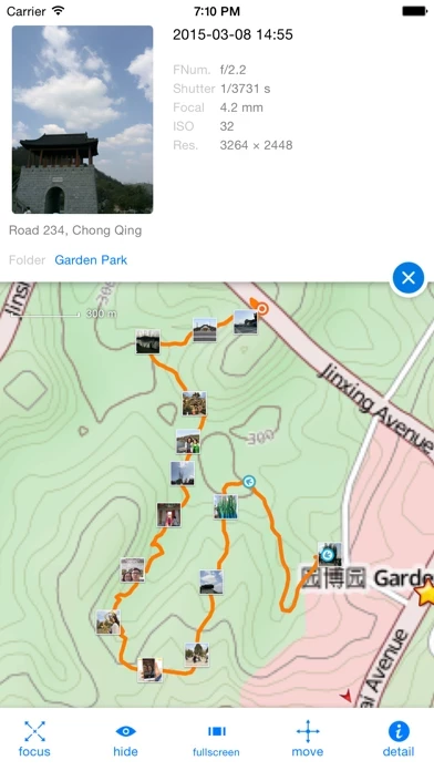
The most powerful and versatile tool for viewing and editing custom maps, surveying, editing or managing mass of your geography or travel data.
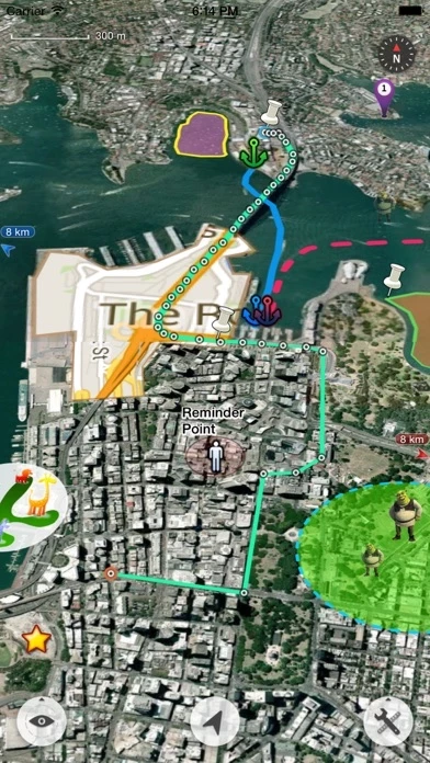
● Supports importing, viewing and downloading thousands of custom online maps, such as OSM, GoogleMap, BingMap, USGS, or any WMS/WMTS map services.
● You can use Map Plus as a professional GIS tool for geographic data gathering, editing, measuring, cartography, surveying, planning, online/offline viewing and many other management.
Captures d'écran officielles

Détails du produit et description de
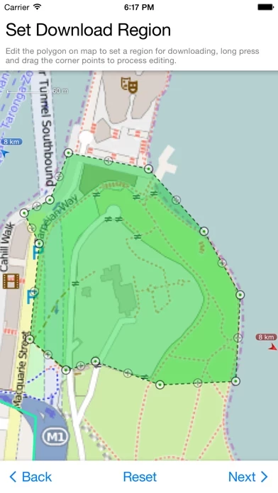
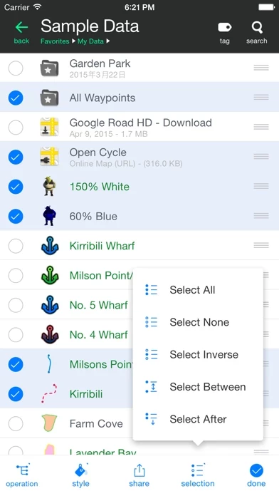
The most powerful and versatile tool for viewing and editing custom maps, surveying, editing or managing mass of your geography or travel data. ● You can use Map Plus as a professional GIS tool for geographic data gathering, editing, measuring, cartography, surveying, planning, online/offline viewing and many other management. ● You can also use Map Plus to help your outdoor activities and global travels, for trip planning, offline map downloading, track/photo/video recording, or sharing memories with friends. Besides common map features such as locating, searching, Map Plus has many more special: ● Supports importing, viewing and downloading thousands of custom online maps, such as OSM, GoogleMap, BingMap, USGS, or any WMS/WMTS map services. Both XYZ pattern and Javascript could be used to define maps. ● Supports importing offline map files such as MBTiles. ● Supports both EPSG:4326 and Web Mercator (EPSG:3857) for raster maps; Supports offset maps using China GCJ-02 datum. ● Importing and exporting KML/KMZ files with full styles, extended data and "gx" extension support. ● Importing and exporting GIS vector files, such as SHP, TAB, GEOJSON, GML/GZ with all EPSG projections/CRS. (using GDAL) ● Importing/Exporting AutoCAD DXF files with blocks, mtext, xdata and affine transformation support for coordinates mapping. ● Importing files of CSV, GDB, MPS, WPT, EVT, PLT, PNT, RTE, etc. ● On-map Editing with Drag-Drop and Magnetic Snap support for all places, tracks, lines, polygons, circles, rectangles, text overlays, etc. ● GPS Track Recording with auto-recovery, custom time zone and background mode support. ● Path Following with voice guidance for own lines/tracks or searched out direction routes. ● Displaying photos and videos on the map based on locations. ● Managing mass data with multi-level folders, layers, bulk operations, shortcuts, tags and fuzzy searches. Advanced Search supports expressions and property conditions. ● Using Feature Class for bulk editing and managing on similar (same kind) features and layers all together. Supports bulk Attributes Merge and Link Relationship Building between features of different classes. ● Conditional Style, Script Property and Expression provide dynamic content of rendering, attributes and text labels. ● Customizable pop-up panel for selecting items on the map with HTML, JS and CSS support to make your own forms, layout and rich-formatted content. ● Displaying coordinates in MGRS or UTM. ● Photo Markup enables you to add arrows, texts, shapes, icons and free-hand draws to a photo. ● Browser Access enables you to upload and view data from a web browser on PC/Mac within a Wi-Fi network, or play slideshow on your TV for travel photos. ● Sharing or transferring data via Wi-Fi, Bluetooth, iCloud, SMS, Email, QR codes, Open-In, AirDrop or many other ways. ● Backup & Restore function helps you backup/restore data to/from files or iCloud easily. ● Many more fantastic and free functions could not be fully listed here, such as Guide Mark, Arrival Notification, Photo Mode, Map Level Adjust, Custom Icons, Photo/Video Attachments, Image Overlay, Text Overlay, Fast Editing, Distance/Perimeter/Area Measuring, Custom Time Zone, etc. User Manual: http://duweis.com/en/mapplus_guide.html User Forum: http://duweis.com/forums/viewforum.php?f=13 Contact Us: [email protected]
Haut Avis
Par Xa\/ier
Super pour la rando
Très pratique de pouvoir télécharger et utiliser les fonds IGN sans connexion ! Très bonne app. Attention aux mises à jour, les iPhones 5 sont bloqués en iOS 10.3.3...
Par مراد المغرب
Merci
Utile, facile et gratuite. Merci infiniment.
Par Bounce31
Just perfect !!!
THE ultimate gps map locator/gps/map reader !!! Using it for backcountry Mx freeriding, and Works just waaaaw