Topographic Maps & Trails Reviews

Topographic Maps & Trails Reviews

Published by

About: ** The #1 Topo Maps App for iOS ** MAIN FEATURES INCLUDE: - USGS Topographic
Maps - USFS Topographic Maps - Satellite + Topo Maps - Hiking Tracker *
Download all maps for offline use USGS TOPO MAP USGS Topo is a tile cache base
map service that combines the most current data in The National Map (TNM), and
other public-domain data, into a multi-scale topographic reference map. TOPO +
SATELLITE USGS Imagery Topo is a ti.


About Topographic Maps Trails


USGS Topo is a tile cache base map service that combines the most current data in The National Map (TNM), and other public-domain data, into a multi-scale topographic reference map.

USGS Imagery Topo is a tile cache base map of orthoimagery in The National Map and US Topo vector data.

Orthoimagery data are typically high resolution images that combine the visual attributes of an aerial photograph with the spatial accuracy and reliability of a planimetric map.

Data themes included are Boundaries, Geographic Names, Transportation, Contours, Hydrography, Land Cover, Shaded Relief, Trails, etc.

The USFS Topo Map Area of Interest covers the USFS National Forests and Grasslands.


Overall User Satisfaction Rating


Positive experience
58.8%

Negative experience
41.2%

Neutral
21.2%

~ from Justuseapp.com NLP analysis of 2,616 combined software reviews.

Key Benefits of Topographic Maps Trails

- Integrates USGS 7.5' maps into a user-friendly mobile database

- Provides free access to detailed maps that other Topo apps charge for

- Allows for offline use, making it useful in areas without internet access

- Provides clear and useful altitude lines for route finding

- Offers the ability to record and visualize hiking or walking paths

- Provides a fast and helpful customer service


20 Topographic Maps Trails Reviews
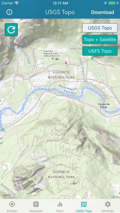
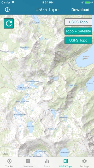
4.6 out of 5

By


Great maps

I’ve been using USGS 7.5’ maps for the past two decades both for work and pleasure. TopographicMapsTrails has integrated the same data into a user friendly mobile database. A similar Topo app requires you to pay for the same detail that is free here as well as on the USGS website. Thank you for the hard work and detail you’ve put into TopographicMapsTrails.

I haven’t had the chance to use this offline yet but I’ll be testing it out soon.


By


I like this but have a question

I use TopographicMapsTrails on my daily hikes and walks and I like keeping a visual record of my outings. My question is what the colors represent in the track graphics. I hike some pretty steep hills and while at first I thought the red-green color variation represented incline, it doesn’t seem to correlate, so now I’m thinking it represents horizontal speed.
It would be nice to know. Otherwise this is the tracker that I’ve been waiting for. Thanks!


By


Planning & Navigation

Pros: 1. Download a topo for a hike.
2. Once tracking is started, a satellite view is presented.
3. You can use tracking mode with satellite view to plan. I discovered this while reviewing a recent hike because there was an old logging road on the satellite view that was not on a topo or Google Earth.
4. Mileage is good.
Cons:
1. I like the satellite view, but it hides the Topo map & thus the trails during a hike. Haven’t figured out how to surmount that.
2. Unless you are in cell range, elevation gain is always way low. Even if you just took your lowest elevation and subtracted it from highest, Topo Maps would be low by at least 25%.
3. Thus far, I cannot find anyway to drop a waypoint or plan a track — e.g., using
Topo as a planning tool.

That said, I love using it for planning & hiking new areas.


By


Impressed new user

I have not used any other Topo map apps, but I’m amazed that this one works with such ease. I remember having to send a letter to the USGS and wait for them to mail back the large map from which you could choose which smaller Topo maps you wanted. Then you had to mail your choices back along with your payment and then wait for the maps to be mailed back to you.


By


Maps in my pocket!

Love maps in general and I’ve always dug topo maps to visualize my present location in relation to physical features when I’m out and about. Topo gives me everything I’ve wanted to have in a convenient, versatile, great looking app. I’ll keep my paper maps for kitchen table planning/dreaming and as backups, but Topo is my new traveling companion 8-). Get it.


By


Great service

I wrote a review about a week ago because the new update caused TopographicMapsTrails to crash and without delay a new update was available and i am back up and running. Thanks for the fast service keep up the great work


By


Very Solid App

TopographicMapsTrails is very easy to use and works great. I wish the maps tab and the tracker tab were combined so I don’t have to flip back and forth. I also wish there was a button to center the map on the current location. I used it in a hike last weekend and it worked great otherwise. Used very little battery.


By


Absolute waste of 5$

Bought TopographicMapsTrails for the soul purpose of using the topography feature. Neither map shows any elevation lines, height or anything of that matter. Identical to the standard apple map layout. It does show more rivers and streams than a casual map would. Ive tried TopographicMapsTrails using my wifi, in different locations, and I've even gone to the extent of downloading a map to see if it changed anything. It doesn't. Very disappointed… do not waste your money. Learn from my experience.


By


Fantastic Topographic App

It’s much more difficult to get Topo maps. This allows you to get maps and then go for hike and your path will be recorded. The maps and altitude lines are clearly rendered and useful for route finding.


By


From Martrinez California

1st impression, it is awesome. I am very impressed with the detail and precision in my area. It will be pleasure to use it other areas and see how well it works for me.
Thank you to all the people that helped to create TopographicMapsTrails.


By


Works Great When Working

Been using TopographicMapsTrails to track my hikes since 2019. Wanted to achieve 1,000 miles in a year but sadly lost approximately 200 miles when TopographicMapsTrails stopped tracking after about a mile. I depend upon accurately tracking my hikes to get donations for homeless and disabled veterans. Losing miles means losing donations.


By


Awesome

I’ve been looking for this map for a while this is just amazing works very well and is accurate so, all I got to say download the map to use offline and just explore. Thank you developer you are just insane 😉


By


Responsive

Emailed the developer. Nearly immediate response. App is good. Wish there was a search feature with plug and search GPS coordinates, however the offline maps and pins make it well worth a primary or secondary topo app


By


Pretty useless as a map

If you are looking for a topo map to use while hiking, save your money and keep looking. If you try to zoom in to any scale small enough to actually be useful while hiking, you lose all topo details. I couldn’t get any smaller than miles without just getting a green screen with roads and trails.
It may be great as a tracker, I don’t know because it is useless for what I want.


By


Great App

The ability to save the maps for offline use is super helpful. Hiking in Alaska means no internet even just outside city limits and having good Topography maps accessible is a lifesaver.


By


I use Topo for hunting and no complaints

I have not been using Topo for long but I have absolutely no complaints. It tracks accurately and shows me where I’ve been and how to get back to my car.


By


Excellent App for Topographic, Elevation and Satellite Informationn

I needed Elevation on lakefront property and TopographicMapsTrails was excellent. I was able to see all the characteristics of the property(elevations, satellite, and Topographic). I could not find any info on the Webb but TopographicMapsTrails had it and was FAST.

Great job team!


By


Excellent value

TopographicMapsTrails is a great value at the price. Don’t get suckered into paying yearly subscription fees from other “free” maps. No more credits to buy tiles for offline downloads.

TopographicMapsTrails allows for unlimited offline map downloads and geospatially
tracks activity very accurately.

I emailed the maker and asked for the option to add waypoints and create tracks. Hopefully those get added soon!

Thanks!


By


Zoom

I like TopographicMapsTrails , just bought it, but it drives me up the f wall when I try to zoom in on a USGS detail and POOF! it’s gone. Please make it pixelate the map layer instead of making it completely disappear.


By


Works great, worth the money

It’s great to have a history of my walks and hikes. The ability to sync between my iPhone and iPad is a great feature.


By


Not that good.....

There is no search so you need 2 maps,
1 to show you how to get to the trail then use this one. When you get to the trail you have to keep app running or lose data. Don’t run out of battery! Around 1/4 of the screen is taken up by clutter(menu choices). It never leaves so quit trying to see map on whole screen.


By


Great detail but DL map issue

It would be 5 stars, but downloading the map is not working for me. Offline With GPS is awesome! That’s half my hunts. I just need the maps to fully download and be zoomable and such.


By


Great app!

I used TopographicMapsTrails for the first time exploring a neighbor’s private property. Lots of mountains and unmarked ATV trails. The Topo app got me to the top with a great view and good detail. My only recommendation is to add a compass feature so the map rotates with the phone.
Great app!!


By


I enjoy looking at topo

Topo maps are great to see what it is like on the mountain where we live, as well as family and friends across the country.


By


A little more data would make the very nearly perfect app

Do an overlay with USGS monuments and data sheets.


By


Good maps and downloading but big drawback

Great overall app and maps but doesn’t have a compass feature or orient the map to heading direction. This makes it very hard to navigate in the back country.


By


Really good!

Love it, does everything simply and no fuss. The ability to save maps for offline use would make it 5 star!


By


Team Jemazzy

This is a great app! Soo many useful maps and not all the extra junk. Plain and simple to use. We will be using this a lot on our journey. Team Jemazzy 2019


By


Amazing App

Smooth, fast and detailed, all for free! Thank you!!


Is Topographic Maps Trails Safe?


Yes. Topographic Maps & Trails is very safe to use. This is based on our NLP (Natural language processing) analysis of over 2,616 User Reviews sourced from the Appstore and the appstore cumulative rating of 4.6/5 . Justuseapp Safety Score for Topographic Maps Trails Is 58.8/100.


Is Topographic Maps Trails Legit?


Yes. Topographic Maps & Trails is a totally legit app. This conclusion was arrived at by running over 2,616 Topographic Maps & Trails User Reviews through our NLP machine learning process to determine if users believe the app is legitimate or not. Based on this, Justuseapp Legitimacy Score for Topographic Maps Trails Is 80/100..


Is Topographic Maps & Trails not working?


Topographic Maps & Trails works most of the time. If it is not working for you, we recommend you excersise some patience and retry later or Contact Support.


How was your experience with Topographic Maps & Trails? Post a Review

Leave a comment:


Alternatives