GOHUNT: Research & Maps Reviews

GOHUNT Reviews

Published by on 2026-04-06

🏷️ About: GOHUNT is an interactive hunting platform that offers tools to hunters for planning, preparation, scouting, mapping, and time in the field. The app provides the best-in-class hunting GPS maps that are built to withstand harsh environments with or without cell service. The Explorer subscription gives access to features such as land boundaries, hunt planning, data import, hunting layers, offline GPS maps, 3D terrain, mapping tools, basemaps, record tracks, and map settings. The app covers all 50 states in the US.


Is GOHUNT Safe to Use?

We Investigate the app owner's website (Gohunt.com), verify their legitimacy, and uncover hidden scams and complaints.


Overall Customer Experience 😎


😎 Positive experience
66.5%

🤬 Negative experience
33.5%

🫥 Neutral
0.0%

~ from Justuseapp.com NLP analysis of 8,407 combined software reviews.

Is GOHUNT Safe?
GOHUNT: Research & Maps is very safe to use.
66.5/100

  Safety Analysis »»

Is GOHUNT Legit?
GOHUNT: Research & Maps looks authentic and legitimate.
66.5/100


Summary of Customer Reviews (Takeaways): 💎

- Awesome app

- Dark mode

- Intentional, thorough and driven by purpose

- Love everything about it

- Terrain analysis feature is key

- Has everything that OnX doesn’t


Read 19 Customer Service Reviews 😠💢

4.8 out of 5
Should have partnered with OnX

From my perspective, GOHUNT lacks everything that OnX has, and has everything that OnX doesn’t. Very frustrating. This data is all open source if you know where to find it. Additionally, it would be very easy to improve upon GOHUNT if you know how to display basic data on a GIS platform. The benefit of creating an app like this should have been ease of use for the general public. GOHUNT is not as easy to use as OnX, and only shows western states.

For the sake of research, GOHUNT is somewhat useful. It should be incorporated with the this app filtering system in an app for for research! But I would not use GOHUNT in the field at all. OnX is far superior in the field.

Just crashes

GOHUNT crashes and takes your track with it. Nothing like putting in a long track hunting to use the next day only to have GOHUNT crash and delete it all. Going back to OnX.

Won’t load

Won’t get past map screen.

Map doesn’t load

I am stuck on the loading screen, can’t get into GOHUNT . Also, no account create?

Can’t get it to load

Have uninstalled and reinstalled twice. Does not get past the Loading Layers screen. iPhone 11 with latest iOS installed.

Wont load

I have installed and uninstalled GOHUNT multiple time and it won’t go past trying to load the map layers. Seems worthless

$150 for unpolished mapping , Gaia is the one to get.

First off you have to be an “insider” to use GOHUNT. Honestly ONx maps is better and Gaia blows this out of the water. These guys are Instagram “hunters”. But hey for $150 you could be one of 500 green horns out spring bear hunting in Idaho blowing out all the game.

Has failed every time

Track does not work. Tracks for roughly 2 hours then screen freezes. Have to close app and reopen to get it to unfreeze, but track has been lost. I like the desktop maps, but mobile app maps are unreliable.

Needs a different pricing model

Bummer that there is not an option for non-insiders…

SO SO

OnX has them beat by miles, won’t ever purchase again, cost to much.

Offline maps

I have a problem with the offline. I cant even open GOHUNT without service so offline maps to me are useless . If im doing something please let me know

Great! But missing a key feature.

You guys do awesome work! Thank you so much for all the research and thought that goes into your content across all platforms. I would love to see your terrain analysis tool worked into GOHUNT as well as the color legend for the different types of filters and layers. Thanks again! Love it!

Love it so far!

Great work this app! Another product I’ll be using daily.

Maps!

So excited for this from the this app crew! Glad they waited to release this and have time to work out the kinks before elk season this September 👍🏼

Great for any outdoorsman

The 3D map and community features on this map are great. Now, instead of word of mouth or my crudely drawn maps of paths I’ve hiked, I can just set way points and screen shot areas to my friends.

Great app but a few bugs

I love the maps app and the cross platform integration. I just wanted to let you guys know the 3D portion had been crashing GOHUNT every time I’ve been using it. I’m sure it’ll get resolved.

Go To Hunting Map App

I have used a few others but the interface and feature of this app’s map app is much better than the rest IMO.

Terrain analysis feature is key is e-scouting. I am spend much less time looking for sign.

No one does it better than GoHUNT

Everything the this app team does is intentional, thorough and driven by purpose. Lorenzo and team did not disappoint with GOHUNT and it’s features. I love everything about it. It’s all about the details and all of them were considered. Phenomenal job this app team!

Awesome work goHUNT team!

I’ve been looking forward to the release of GOHUNT since I heard that it was coming.
GOHUNT is awesome and you guys got it out at a good time so people have time to use it for planning hunts this fall. I really like the dark mode and how GOHUNT functions.


Is GOHUNT Safe? 🙏

GOHUNT: Research & Maps is very safe to use. JustUseApp Safety Score for GOHUNT is 66.5/100.
This assessment is based on our NLP analysis of 8,407 user reviews. Combined with the app store average rating of 4.8/5.

Safety Analysis

89.5% of users say app is safe 👍
89.5%

9.4% of users have some concerns ⚠️
9.4%

1.1% of users say app is risky 🚨
1.1%


Is GOHUNT Legit? 💯

GOHUNT: Research & Maps looks authentic and legitimate. Our NLP models processed user feedback to estimate legitimacy. JustUseApp Legitimacy Score for GOHUNT is 66.5/100 .
This conclusion is based on analysis of 8,407 user reviews.

🔏 Privacy & Data Safety

GOHUNT collected the following data from you:

  • Data Used to Track You:
    • User Content
    • Identifiers
  • Data Linked to You:
    • Contact Info
    • User Content
    • Identifiers
  • Data Not Linked to You:
    • Location
    • User Content
    • Usage Data
    • Diagnostics

Payments 💸

**Pricing data is based on average subscription prices reported by Justuseapp.com users..

Pricing Plans Amount (USD)
Insider (Trial) $149.99
Explorer (Annual) $49.99
Insider (Annual) $149.99


How was your experience with GOHUNT: Research & Maps? Post a Review


Features

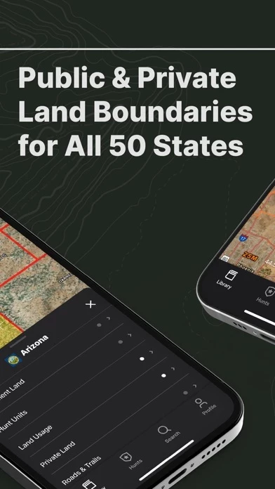
- Public/private land boundaries, hunt units and districts, and more show you exactly where you can and can’t hunt

- Plan and share your entire hunt plan with other GOHUNT users across all your devices (desktop and mobile)

- Simple data & waypoints import your from other mapping apps using a computer. Hunters can import any .gpx or .kml compatible file.

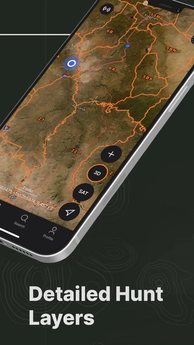
- Easily filter for public and private land, government land, walk-in access properties, hunt zones (antelope, bighorn sheep, deer, black bear, elk and more) with species distribution, hunt units, land usage (grazing allotments and timber cuts), terrain of upwards of 11,500 ft, unit boundaries, water, wildfire, trails, and more during your hunt

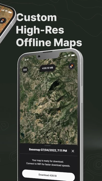
- Download your hunting maps and confidently use your phone's GPS without cell service

- Visualize your approach with realistic terrain analysis

- Measure and mark your secret spots with waypoints, lines, tracks, photos, and more

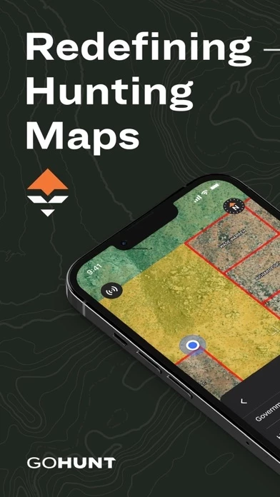
- The most accurate satellite and topographic maps with every detail you need for your hunt

- Always find your way back to your camp with accurate GPS tracking

- Ability to display map coordinates, crosshairs, outlines, open to last viewpoint, and more

  Contact Support
Developer:
goHUNT

Contact e-Mail:

Website:

Privacy Policy: