Tracks4Africa Guide Overview
What is Tracks4Africa Guide?
The app is an offline travel guide for overland travel in Africa. It offers a detailed map and a huge amount of information about places of interest for planning a safari. The app works offline, and your GPS location ensures that you stay oriented while using the app on your self-drive trip. The app contains samples of the map and guide information, which can be upgraded to full country maps and guides.
Features
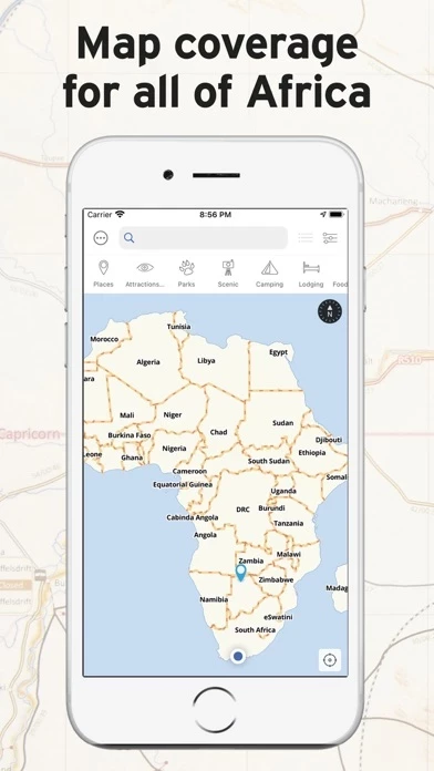
- Detailed map of the country or region you purchase, with place names like cities, towns, and villages, a detailed road and track network, and all protected areas such as national parks and game reserves.
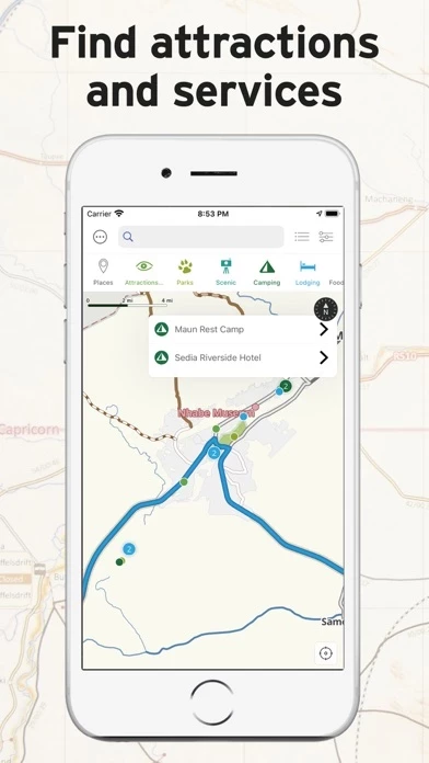
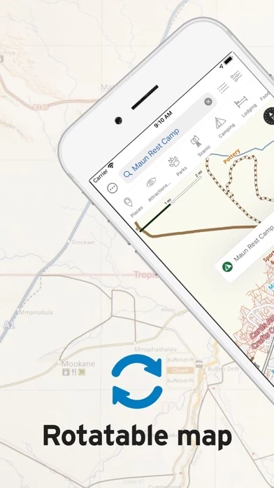
- Detailed guide with categories such as Places, Attractions & Activities, Parks, Scenic, Camps, Lodging, Food & Drink, Fuel, Shopping, Services, and More.
- The guide information is linked to a location on the map and will display as a pin on the map for you to know where it is in reference to where you are.
- The app will display a map of the country or region and allow you to switch on different categories of points of interest.
- You can search for specific places by name, and the map search is location-sensitive.
- Your position, determined from your iPhone or iPad’s location service, will display on the map so you can accurately orientate yourself on the map.
- The search functionality is linked to the guide categories, and you can find a campsite by switching on the Camps category or entering the name of a campsite into the search block.
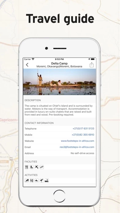
- Points of interest will have associated information such as a description, contacts details, facilities and activities, and some places will have photos.
- Guide and Map content is updated once a quarter, and available for download if you have purchased the relevant guide.
- You can contact the app developers at [email protected] or via their Facebook page: facebook.com/Tracks4Africa.
Official Screenshots

Product Details and Description of
Welcome to the most detailed travel guide for overland travel in Africa. This offline app offers a great map and huge amount of detailed places of interest for planning your next safari. Your GPS location will ensure you stay orientated while using the app on your self-drive trip. Try it out The app contains samples of the map and guide information, which can be upgraded to full country maps and guides. How does it work? This is not a routing/navigation app. The app aims to bring you offline access (i.e. no internet connection required) to the following: • A detailed map of the country or region you purchase. The country map roughly corresponds to a 1:1 000 000 paper map in terms of its detail and will allow you to view the map at different zoom levels. The map works similar to a web map with the difference being that all information is installed on your device. It contains place names like cities, towns and villages together with a detailed road and track network. It also shows you all protected areas such as national parks and game reserves together with relevant background data such as rivers, mountains and major attractions. • A detailed guide with the following categories: Places (cities, towns, etc), Attractions & Activities, Parks, Scenic, Camps, Lodging, Food & Drink, Fuel, Shopping, Services and More (miscellaneous points of interest). The guide information is linked to a location on the map and will display as a pin on the map for you to know where it is in reference to where you are. The app will display a map of the country or region and allow you to switch on different categories of points of interest. You can also search for specific places by name. The map search is location sensitive, i.e. results will be relative to the centre of the map. Your position, determined from your iPhone or iPad’s location service, will display on the map so you can accurately orientate yourself on the map. As you drive, your location will update on the map so you always know where you are. (iPhone or iPad with GPS required) The search functionality is linked to the guide categories. For example, if you need to find a campsite, simply switch on the Camps category. Immediately all campsites around you will display on the map and you can click on them for more information. Otherwise, if you know the name of a campsite, enter it into the search block and relevant results will be filtered. What kind of information can you expect? Apart from the categories already mentioned, points of interest will have associated information such as a description, contacts details, facilities and activities and some places will have photos. Have a look at the sample data in the free app to get an idea of what we offer. What about updates? Guide and Map content is updated once a quarter, and available for download if you have purchased the relevant guide. Talk to us We sincerely would like to hear what you think of the app. If you place a comment, question or suggestion in the review section, we cannot reply to you. So please drop us a line so we can engage and learn what you would like to see in subsequent releases of our app. You can contact us at [email protected] or via our Facebook page: facebook.com/Tracks4Africa.
Top Reviews
By hdhrfewoiuawregffhalj
I live in Namibia and use this all the time
It’s the best. All kinds of cool data for road trips.
By NeelsL
Helpfull
Lots of information for planning a trip and lots of information whilst on the trip. Places you on the map of your gps enabled device and supplies all relevant info in your immediate area such as fuel, lodging, shopping, camping and poi’s. It does not navigate but it gives the waypoints for these places to enter into your navigation system.
By chiptoon
excellent
Straightforward and easy to use. Highly recommended