I hate to be so critical, but I’ve done some light app development and while the transition from the former app to this went smoothly, the functionality of the map view is poor.
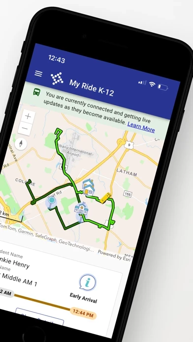
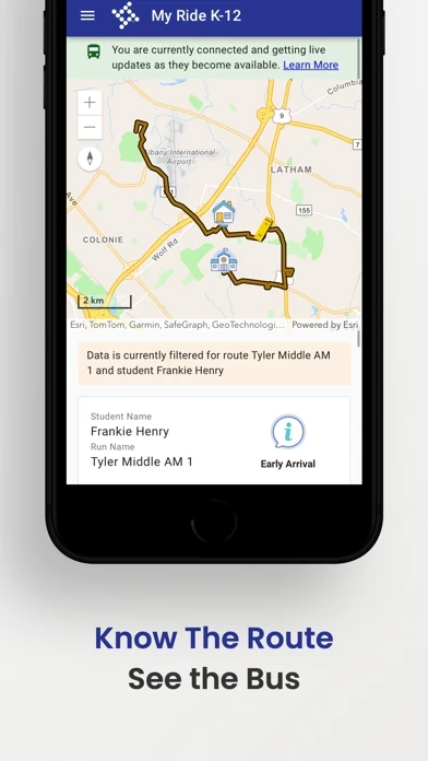
Yes, the bus location updates periodically (likely based on the signal availability for the bus to local cell sites). As the bus appears to approach my child’s bus stop/pickup location like any other user, I will zoom in to more precisely examine the location. The zoom in view will hold for ONLY until another update is received of the bus location. Once the bus location is received, the view zooms out to a bus icon the size of approximately over 3,500 ft. Keep in mind, a mile is just over 5,200 feet. To give you a sense of scale, I’ve checked on both an iPhone and an iPad, the view will zoom out after every location update to fit in approximately 5 miles of visible map from north to south. Oh, and the bus icon i mentioned? It’s 2/3 of a mile long. The icon of my house appears to be just over a half mile in size as well. Trust me, I’ve checked this based on intersections and landmarks visible on MyRideK12 . I’m sorry, but when the map view every update is reset to a zoom of the bus taking up what is the equivalent of 9 to 10 city blocks, what’s the point? Great, you go to the trouble of calculating estimated arrival time. There is almost NO algorithm or formula, or any potential machine learning that is going to accurately predict the nuances of getting a child out the door. Some kids make the bus wait, some kids are waiting as the bus arrives. Some bus drivers let every single car waiting at an intersection pass before they ever attempt to take the right of way. Trying to predict the arrival time while appreciated, is less important than being able to accurately visualize the distance as represented on a map. Stop resetting the zoom view after every location update.