Footpath Route Planner Reviews

Footpath Route Planner Reviews

Published by on 2024-10-01

🏷️ About: Footpath is a route planning and navigation app that allows users to map out custom routes for various activities such as running, cycling, hiking, and more. The app provides features such as distance and elevation measurement, turn-by-turn navigation, and the ability to save and share routes. Users can also upgrade to Footpath Elite for additional features such as premium maps, route organization, and analysis tools.



Overall Customer Experience 😎


😎👌🔥 Positive experience
49.9%

👿🤬😠 Negative experience
26.4%

🙄💅🫥 Neutral
23.7%

~ from Justuseapp.com NLP analysis of 18,731 combined software reviews.


Summary of Customer Reviews (Takeaways): 💎

- The new Footpath Outdoors map combines all the information of the old maps without the jarring switch.

- The app has a brief tutorial with only the basics covered, but other features can be found by poking controls in the corners.

- The new editing tools are hugely welcome.

- The app allows for easy route planning, saving, and subsequent export to a device.

- The app has the potential to resolve routing without a computer handy.


Read 27 Customer Service Reviews 👿🤬😡😠💢😤

4.8 out of 5

Clunky, hard to use for long distance

2022-05-21

The drawings don't really go where you want them to--FootpathRoutePlanner has a hard time figuring out not to turn you around on bridges, for instan
ce. Also if you want to go more than a very short distance you have to go through the clunky process of moving the map, pushing draw again, drawing, undoing six times until the thing reads where you want to go, then pushing done, then moving the map and repeating until your route is complete. And if you want to make a change to your route, forget it-you have to start over.

It's a great idea and on its way to being something that could resolve routing without a computer handy, but honestly it's disappointing for a paid app. It works like an early beta test at best.

Free version of app is horrible!

2022-06-22

I got the free version of FootpathRoutePlanner to create routes for cycling with my bike club/walking my dog and it was awful! You can only view your most recent route that you’ve made and you have to delete all others to see just one! The idea is great and I’m sure the “elite version” is amazing because until I found out I can only view my most recent route, I was loving FootpathRoutePlanner. If you are willing to pay for the full version then FootpathRoutePlanner is great for you but if you aren’t, steer clear of FootpathRoutePlanner and don’t waste your time. Also, with the free version, once you have saved the route you can’t edit it and you have to make an entirely new one! If you are in need of an app like this and think that you would use it on a daily basis then I think you should get the full version but if you’re like me and just getting FootpathRoutePlanner to try out and use rarely then definitely stay away.

Could be good, but not for my needs

2022-07-23

I feel bad rating this too low because I did not use it for very long. However, that is because I started to get genuinely upset with it. It seems that it would be great for legitimate trails, city streets, etc. However, I had great difficulty getting it to stick to actual suburb roads. At one point it decided I should take a nice detour and bike through the pond. When drawing a simple path with a stylus, it thought it would be fun to throw in a few circles. Additionally, it did not give me sufficient editing abilities. On one trip I tried to map, it had a random straight line going through a woods. I attempted to erase it so I could shift it over, but it just kept reappearing in a different, equally incorrect location. It also completely ignores a popular footpath. The “snap to map” is somewhat a useful, and certainly an innovative feature. It just needs some love. I could see this working on longer trips that need less accuracy, but for my suburban 10 mile excursions it brought nothing but anger. For now, I’m going to stick to drawing vauge lines on a map, and finding out the mileage later.

TLDR: I can see it’s applications and situations it could be good in. It just is not at all conducive to my biking or running excursions.

Good for what it is

2022-08-24

FootpathRoutePlanner is pretty good because it allows you to use your finger to create a route and not find a existing route or create a route using particular points. The thing I don’t like is that just to save unlimited routes you have to pay money. I mean common! This is just a route creator and you have to pay! I only kept FootpathRoutePlanner because there is simply no app which can do the same thing but with unlimited routes. Hopefully some day the developers will realize their giant mistake and actually make it free but until then I suggest only get FootpathRoutePlanner if you’re okay deleting routes, only being able to save 5 routes, and if you wanna get all the great features pay.

The best has just gotten better

2022-09-25

OK this is going to be a rave.

Nobody is mentioning what I thought was the most interesting thing about new version 3. The old version would switch maps automatically depending on zoom level, but the new Footpath Outdoors map appears to just combine all the information of the old maps without the jarring switch.

The tutorial is very brief with only the basics covered, but if you haven’t found a feature you want - for me it was how to switch snap types on the fly - keep poking controls in the corners and it’s a good bet you’ll find it in one of them. (The snap switch is a few extra taps to switch but it does work smoothly and consistently.)

The new editing tools are hugely welcome! I don’t recall if I could edit saved routes in the old version, but that’s in here now. I haven’t found a way to edit start points, so unless I’m just missing something I’d recommend zooming in very close on your start point and then backing out to complete the route.

I also appreciate the new account system where I can create/edit routes on my iPad and see the same routes on my iPhone. The grandfathering of my old saved routes into the iPad was very nice - I was briefly afraid I’d have to pay again until I found the secret instruction to invoke it. (Pssst - hey dev, I’d have paid it anyway, but thanks, that was very kind.)

Plan Your Routes, Vary Routes, Vary Distance

2022-10-26

FootpathRoutePlanner is absolutely indispensable for runners who want plan their routes, whether it is to vary their routes but not their distance, or if they just want to map out new routes. FootpathRoutePlanner has allowed me to map out several routes of varying distances (from 4 to 10 miles) without having to cover the same real estate twice. The mile is pretty accurate too, matching the distance of my Garmin Fenix 3 +\- .05 miles. If I could export routes to other apps, or enabled FootpathRoutePlanner to give turn-by-turn directions over Bluetooth, FootpathRoutePlanner would be that much more useful.

This is such a cool App!

2022-11-27

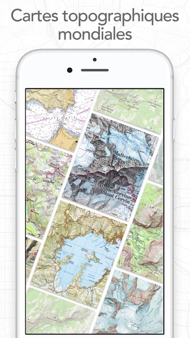
FootpathRoutePlanner is perfect for planning routes, and I’m enthralled by how FootpathRoutePlanner even has all the small/secret trails in my area, it makes for exciting runs/hikes. I even like how there are more than ten different map types, including a nautical map (so cool). One of the coolest things about FootpathRoutePlanner, other than the fact that you can make routes, is that FootpathRoutePlanner color codes hills based on difficulty, very cool. FootpathRoutePlanner inspires me to run more, and it helps me keep track of my miles, keep up the good work!

So good!

2022-12-28

I was looking for an app to plan routes for my runs so I could run certain lengths and I have hit the jackpot! It seems accurate and is super easy to use. I also like how the route drawer doesn’t force you to run on streets. That allows you to plan routes while running off trail! Also, it has a tool that will make sure your route drawing stays on the road. This is an extremely functional app. Even without in app purchases, FootpathRoutePlanner is great.

UPDATED: All routes NOT lost

2023-01-29

I originally thought all routes were lost after this update. They were not lost! The routes were located in a list named “Other.” This may have occurred when I transferred everything to a new iPad. In any event, this is a great app. I use it mostly to track where I’ve been rather than where I’m going, but I love it!

Original review:
Just updated FootpathRoutePlanner and lost ALL of my routes. Unbelievable. Use with caution and don’t trust it with anything you care about.

Excellent for creating routes!

2023-03-02

This is the only app I have found that allows you to create routes by touching a trail. You don't have to touch every spot, just every half mile or so and the route "snaps" to the trail. When done it displays distance and an elevation profile. A number of different background maps are available, including USGS Topo, satellite maps, etc. Access to the maps are via WIFI or cellular data. However the saved routes can be exported to other map apps that can download maps for off-line use.

Highly Recommended

2023-03-31

I just started using this route planner and I LOVE it. A few others in the past have been good, most are designed for iphone and don’t do landscape on ipad (I hate that). One of my favorites just got CRAZY expensive, so I went hunting. This one is $23/year, which is an excellent value in that is allows super easy route planning, AND route sharing/following. To the latter, routes can be loaded into an Apple Watch and followed/recorded as you ride (or run), and routes directions can even be download for offline use (fantastic!).

Fantastic hiking app

2023-05-02

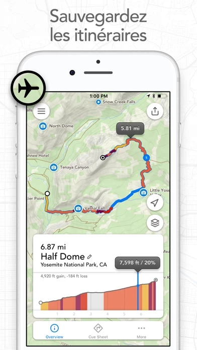
The best app I know of to plan a hike. It’s so easy to see what you’re in for when deciding where to go. The two key things I want to know are distance and elevation gain and FootpathRoutePlanner makes it simple to learn both before I head out. Plus it also shows the gradients along the way plus where I am on the trail. And if while on the trail I want to consider changing my route it lets me know the distance and elevation gain on my new proposed route.

Really well designed and works almost flawlessly.

Best and most Accurate Route Planner by Far

2023-06-02

I am an avid trail runner and hiker and I basically use FootpathRoutePlanner every day. I like to change up The routes I run/hike so that they are always fresh to me and FootpathRoutePlanner has been such a useful tool in helping me do so.

The free version is useful for anyone, but I am subscribed to the premium version (which is very fairly priced considering I use FootpathRoutePlanner so much) because I really like to save routes so that I can analyze them before I run or save my favorites to run again in the future.

I also race many times a year and some of the races are too far away for me to do a pre-run to check out the course design. Footpath allows me to plan out the route beforehand and view altitude changes along the route so I know what to expect when I run on race day.

Definitely recommend FootpathRoutePlanner to anyone as FootpathRoutePlanner is versatile for walking, running, hiking, biking, etc.

Keep up the great work, Footpath!

Works well for me

2023-07-04

I don’t currently have an iPhone, Apple Watch or Fitbit that could map my hiking and running. Plus I don’t always want my location services on.

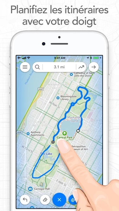
Using your finger or a stylus, you use this to map out distances and routes for hikes and running/walking. I travel a lot and get out and explore whenever I can and I use FootpathRoutePlanner often. Overall it seems to do a good job of finding/tracking the trails and roads that I use. It also gives you elevation gain, which is pretty helpful, especially if I’m hiking in the foothills or canyons.

Stellar

2023-08-04

I've been using FootpathRoutePlanner for a few years now, and it's been consistently improving. When I started using it, it was a good app, now it's great.

Planning to run specific distances is challenging. Unless you're ok with doing out & backs for the rest of your life, you're going to have to start making some loops, and that's where this really shines.

The capability of _quickly_ creating routes to export as GPX Tracks that can be uploaded to your favorite running watch alone makes FootpathRoutePlanner indespensible, but the ease of creating the routes is what really makes FootpathRoutePlanner special. The technology honestly blows my mind. Making new and interesting routes has become a kind of mindless past-time which leads to some pretty interesting rewards while running.

I'm pretty busy, so writing reviews doesn't normally make it into the priority list. FootpathRoutePlanner is so useful, helpful, and simple to use that I felt compelled to say something about it. Get it. You'll be glad you did.

This app is incredible

2023-09-05

I use Footpath multiple times a week and couldn’t be more impressed. Most of my runs are on trails and my Garmin isn’t even close to as accurate as FootpathRoutePlanner. The trail maps are remarkably extensive and I also use it find trails which don’t appear on Garmin, Google, or Strava. Most of my experience with FootpathRoutePlanner is in Portland, Oregon but I use it when I travel and it’s worked great everywhere I’ve been.

Overall FootpathRoutePlanner is intuitive and easy to use. The drawing feature is super useful with snap to map on or off and everything loads really quickly. The maps are beautiful and the ability to store lots of routes made the elite version worth it for me. I’ll be using FootpathRoutePlanner for a long time.

Exactly what I was looking for.

2023-10-07

FootpathRoutePlanner is exactly what I have been looking for for hikes & MTB rides. The feature that allows you to trace your route is fantastic & the development team did a great job programming the software to figure out what my fat fingers are trying to tell it!

I haven’t used all the features that FootpathRoutePlanner offers, so I’m sure I’ll find even more features to love about it.

The only thing that I wish it had was either a “vehicle-driven” mode or even better, the developers would create another fantastic app just like “footpath” for offroad vehicles. Seriously, some of the Offroad apps are fetching $50-$80/yearly subscription & ive wasted over $100 already on a few of them. I’d gladly pay for one such from this same development team. Perhaps you could call it “tread path” or “tire path”! You can use that suggestion however you like, but I would welcome a free subscription ;-)

Anyway- if you hike, ride off road/on road, or hunt for Sasquatch & want to be able to plan out your route to do so, get FootpathRoutePlanner. You’ll love it, I promise. If I’m wrong, you can say mean things about me on the internet.

This is an excellent App with minor issues

2023-11-07

So I totally appreciate how it tells your height of the hills. I never ever take this with me. So every morning I do 5.73 miles. I do the 3 highest hills in Watertown Ma. Today I did it 1.41 hours. The only issue I have with this. Is when you say the exact address. I place’s you in the area. This is minor. But then once you are where you start. When you start. And you put it up 3 streets. It try’s to suggest this way. So you have just take your time. But I love FootpathRoutePlanner. Another thing, if you want to change the route slightly. It makes you to have to re route the whole thing. Because since March 13 when the Gym closed. I gained 4.6 pounds in the first 2 days. Now, I’m even to the gym. FINALLY!

Great idea, hard interface

2023-12-09

I really really want to love FootpathRoutePlanner. It has so much potential. But, honestly, the route scripting in urban environments is poor. It doesn’t adjust easily. It assumes you want to do out and back or other options and makes them hard to correct. It will not allow you to draw paths where it doesn’t know they exist. So, for example, there is a well known path through a public right of way in my neighborhood; because FootpathRoutePlanner doesn’t know about it, it wants to add an additional two miles to my route.
Why is it so hard to just have a simple routing app that calculates mileage?!? Why can’t an app just trust that I know what I’m routing when I want to tell it, yes, I can go that way? So much potential, but the bells and whistles defeat the basic purpose of FootpathRoutePlanner .

Excellent GPX planning app

2024-01-09

When I ditched my MacBook Air several months ago, I was looking for a replacement to using my previous route planing website, which allowed for GPX export I could then subsequently load onto my Garmin Fenix 3. What seemed like an easy chore, proved very difficult. Footpath was the solution I was looking for! Easily planned routing, saving, and subsequent export to my device has made FootpathRoutePlanner a no-brainer for me. The recent Fall upgrade has made it even better.

Question: previously, I was able to manually arrange my created/saved routes in any order I wished. I’m not able to do that since the most recent update. Am I missing this feature, or was it removed? Previously, I tapped the “edit” button, and, in addition to the red delete symbols along the side, it had little “grabbers” beside each route that I used to order them according to my preference.

Great app, but backend is falling down

2024-12-16

I used to use FootpathRoutePlanner daily to plan my running route, then it started having backend errors constantly when snapping to roads and sat broken for a long time. The developer updated it but whatever new mapping backend it’s using is not good. FootpathRoutePlanner displays Google Maps but the backend that does the snapping to roads clearly uses a different mapping provider. Very frequently it doesn’t match the Google Maps map and makes it hard to accurately plan a route - it misses a lot of trails and does some odd things on roads. It’s often impossible to make a simple route without disabling road snapping. I’ve switched to a different route planning app without this problem and deleted Footpath.

Could better or easier to use

2024-12-16

Using this for biking I had to plot out like every 15 miles to make sure it kept on the bike trail system from Cincinnati to DC even though the trail covers about 75% of the ride. It was set to biking but loved putting me on interstates, or would just put a line through an area with nothing road or trail-like. It assumes I want to carry my bike and supplies across a river? And...where do I get the turn-by-turn directions? Looked at the Elite aspects to this and it didn't indicate it allows that feature.
After getting flustered with this for 3 hours I realized Google Maps allows you to search specifically for a bike trail between two points. *sigh*

Does what it promises

2024-12-16

Takes a little practice to finger-draw a path that will snap just to the streets you had in mind. Easy (and often necessary) to draw in segments, mixing snap and non-snap portions, although it can get tedious deleting, since erase is sequential by last-drawn segments only. Plan on paying one more time if you want more than the bare minimum function. Includes and provides easy switching between half a dozen street, satellite, topographical and specialized walking and cycling maps - basic price is worth it just for those.

excellent

2024-12-16

For years I’ve used Footpath to plan my hikes and paddles, I can see everything I need to know about a trail in great detail before I set out.

The newest update is wonderful, graphically the maps are really nice, there is an option to make lists to sort routes, and snapping to trail/street is working very well when drawing a route. I upgraded to Footpath Elite to access the topo and nautical maps.

The developer is friendly, active, and helpful. I love outdoor activities and I use FootpathRoutePlanner daily, it’s indispensable.

Love the altitude tracker on the map

2024-12-16

This is a wonderful tool for planning a walk, hike, run, or bike ride, but also works when you map it after a walk. I'm always happily surprised I went that far! FootpathRoutePlanner keeps getting better and better with each new version. It's great to see how your elevation changes right on the map when you run your finger on the altitude bar. Fantastic tool! Love being able to map out on my iPad and get in my iPhone.

Great app, figure out routes quickly

2024-12-16

This is amazing. The run mapping app I’ve been waiting for. If I’m trying to figure out a run to do on roads and want a basic idea of distance, I don’t have to spend 10 minutes using some online mapper hoping I don’t accidentally click on a business and have to hit undo a bunch. This takes about 30 seconds to figure out how long a route you may have in mind is. Great app!

Awesome!

2024-12-16

Such a useful tool for people that are new to an area that they want to bike or run. The snap to roads feature makes routing very simple. Literally look at the map, drag your finger where you want to go, and it will make a route for you. It also will give you the altitude for the trip that shows you an overall change in elevation as well as showing you where the high and low spots are. Love it. Such a great find!


Is Footpath Route Planner Safe? 🤗🙏


Yes. Footpath Route Planner is very safe to use. This is based on our NLP (Natural language processing) analysis of over 18,731 User Reviews sourced from the Appstore and the appstore cumulative rating of 4.8/5 . Justuseapp Safety Score for Footpath Route Planner Is 65.4/100.


Is Footpath Route Planner Legit? 💯


Yes. Footpath Route Planner is a totally legit app. This conclusion was arrived at by running over 18,731 Footpath Route Planner User Reviews through our NLP machine learning process to determine if users believe the app is legitimate or not. Based on this, Justuseapp Legitimacy Score for Footpath Route Planner Is 96.4/100..


Is Footpath Route Planner not working? 🚨


Footpath Route Planner works most of the time. If it is not working for you, we recommend you excersise some patience and retry later or Contact Support.


Payments 💸🤑💰

**Pricing data is based on average subscription prices reported by Justuseapp.com users..

Pricing Plans Amount (USD)
Footpath Elite (Monthly) $3.99
Footpath Elite (Yearly) $23.49
Single Route Pass $1.99


How was your experience with Footpath Route Planner? Post a Review


Features

- Map routes by tracing with finger or Apple Pencil

- Snap to roads and trails on the map

- Measure distance and elevation with elevation profiles

- Save up to 5 routes with the free version, or unlimited routes with Footpath Elite

- Share routes with friends or workout partners

- Compatible with various activities such as running, cycling, hiking, and more

- Footpath Elite features:

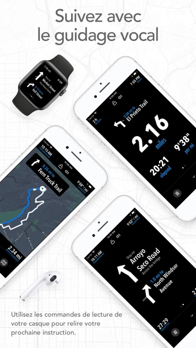
- Turn-by-turn navigation with audio cues on iPhone and Apple Watch

- Premium maps including 3D and topographic maps

- Cycling lanes, avalanche slope shading, and elevation contour lines

- Organize and edit unlimited saved routes

- Analyze splits, speed, elevation, and heartrate

- GPX import and export, TCX and FIT course export for turn-by-turn navigation on Garmin and Wahoo GPS devices

- Export routes and workouts to Apple Health

- Tips for mapping routes provided within the app

- Contact support for feedback or issues

- Terms of Service and Privacy Policy available for review.

  Customer Service/Support
Developer:
Half Mile Labs LLC


Website:

Privacy Policy: