Navitel Navigator Software
Company Name: Navitel
About: Navitell is a Belgium-based technology company specialized in mobile storytelling.
Headquarters: Lummen, Limburg, Belgium.
Navitel Navigator Overview
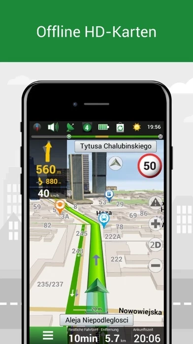
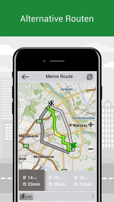
What is Navitel Navigator? Navitel Navigator is an offline navigation app that provides detailed maps of 66 countries. It offers free geosocial services and a 7-day free trial. The app has several advantages, including offline navigation, no additional expenses on roaming, and no dependency on a mobile connection. It also has special features such as Navitel.Traffic, Navitel.Friends/Cloud, Navitel.Weather, Dynamic POI, Navitel.Events, SpeedCam warnings, 3D Mapping, 3D Road interchanges, Lane Assist, Multilanguage support, Turn-by-turn voice guidance, Dashboard, Fast route calculation, Unlimited number of waypoints for routing, Customizable user interface, and Multitouch support.
Features
- Offline navigation
- Offline maps of 66 countries available for purchase
- Map subscription for a limited period (1 year) with prices starting at 10.99$
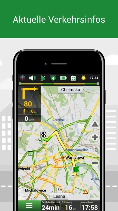
- Navitel.Traffic for real-time traffic information
- Navitel.Friends/Cloud for messaging with friends, tracking their location, and routing towards them
- Navitel.Weather for weather forecast information for the next three days anywhere in the world
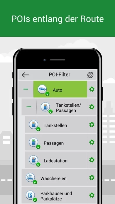
- Dynamic POI for fuel prices, movie showtimes, and other useful information
- Navitel.Events for road accidents, road works, speed cams, and other events marked on the map by users
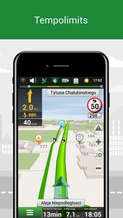
- SpeedCam warnings for information on radars, video recording cameras, and speed bumps
- 3D Mapping for three-dimensional maps with texture and number of floors support
- 3D Road interchanges for displaying multilevel road interchanges in 3D mode
- Lane Assist for route calculations taking multilane traffic into account and visual prompts while following the route
- Multilanguage support for the interface and voice prompts in multiple languages
- Turn-by-turn voice guidance for voice guidance while moving along the route, warnings on the battery charge, and connection to the satellites
- Dashboard for more than 100 different gauges: time, speed, weather, and other parameters
- Fast route calculation for instant calculation and routing of any length and complexity
- Unlimited number of waypoints for routing for easy routing with a limitless number of waypoints
- Customizable user interface for adapting the program interface and map display mode for your own needs
- Multitouch support for quick access to map scaling and rotation functions via the multitouch input
- Purchase through the program menu for purchasing new map packages and updating the purchased ones through the "My Navitel" menu.
Official Screenshots
Product Details and Description of
Navitel Navigator is precise offline navigation with free geosocial services and detailed maps of 66 countries. Try popular navigation for 7 days free! ADVANTAGES • Offline navigation. No Internet connection required for the use of the program and maps: No additional expenses on roaming or dependency on a mobile connection. • Offline maps of 66 countries are available for purchase. • Map subscription: Map purchase for a limited period (1 year) with prices starting at 10.99$. SPECIAL FEATURES • Navitel.Traffic. Information on all traffic jams in the covered area, available in real-time. • Navitel.Friends/Cloud. Messaging with friends, tracking their location, and routing towards them. Program settings and waypoints are stored in the NAVITEL cloud storage. Log in to Navitel.Friends/Cloud service using your social network profile (Facebook, Twitter) • Navitel.Weather. Weather forecast information for the next three days anywhere in the world. • Dynamic POI. Fuel prices, movie showtimes, and other useful information. • Navitel.Events. Road accidents, road works, speed cams, and other events marked on the map by users. • SpeedCam warnings. Information on radars, video recording cameras, and speed bumps. • 3D Mapping. Three-dimensional maps with texture and number of floors support. • 3D Road interchanges. Displaying multilevel road interchanges in 3D mode. • Lane Assist. Route calculations taking multilane traffic into account and visual prompts while following the route. • Multilanguage support. Support of the interface and voice prompts in multiple languages. • Turn-by-turn voice guidance. Voice guidance while moving along the route, warnings on the battery charge, and connection to the satellites. • Dashboard. More than 100 different gauges: time, speed, weather, and other parameters. • Fast route calculation. Instant calculation and routing of any length and complexity. • Unlimited number of waypoints for routing. Easy routing with a limitless number of waypoints. • Customizable user interface. Ability to adapt the program interface and map display mode for your own needs. • Multitouch support. Quick access to map scaling and rotation functions via the multitouch input. • Purchase through the program menu. Purchase new map packages and update the purchased ones through the "My Navitel" menu. OFFLINE NAVIGATION MAPS FOR PURCHASE Albania, Andorra, Armenia, Argentina, Austria, Azerbaijan, Belarus, Belgium, Bosnia and Herzegovina, Brazil, Bulgaria, Colombia, Croatia, Cyprus, Czech Republic, Denmark, Estonia, Finland, France, Georgia, Germany, Gibraltar, Greece, Hungary, Iceland, India, Iran, Isle of Man, Italy, Kazakhstan, Kyrgyzstan, Latvia, Liechtenstein, Lithuania, Luxembourg, Macedonia, Maldives, Malta, Mexico, Moldova, Monaco, Mongolia, Montenegro, Netherlands, Norway, Pakistan, Peru, Philippines, Poland, Portugal, Romania, Russia, San Marino, Serbia, Slovakia, Slovenia, Spain, Sweden, Switzerland, Tajikistan, Turkey, Ukraine, United Kingdom, Uzbekistan, Vatican City State, Vietnam. If you have any questions contact us: [email protected]. We will be happy to help you. CONNECT WITH US Facebook: http://www.facebook.com/NavitelWorld Instagram: http://instagram.com/navitel_en Continued use of GPS running in the background can dramatically decrease battery life.
Top Reviews
By imunal
Jane
Very good interface with a lot of information like speed cameras on the way and other regulations. You can turn the sound off if you don't like the beeps (I think it's safer that way), there is still colour indication very easy to spot and decelerate if you need to.
By Kagamlyk92
Igor
Very good quality maps with detailed information. One thing you should maybe work on - voice activated search.
By snafe55
طلب
1-WHY NO There is no Keyboard Arabiya 2- WHY NO There is no language Arabiya in the program