How to Cancel Navitel Navigator
Published by NavitelWe have made it super easy to cancel Navitel Navigator subscription
at the root to avoid any and all mediums "Navitel" (the developer) uses to bill you.
Complete Guide to Canceling Navitel Navigator
A few things to note and do before cancelling:
- The developer of Navitel Navigator is Navitel and all inquiries must go to them.
- Check the Terms of Services and/or Privacy policy of Navitel to know if they support self-serve subscription cancellation:
- Cancelling a subscription during a free trial may result in losing a free trial account.
- You must always cancel a subscription at least 24 hours before the trial period ends.
Pricing Plans
**Gotten from publicly available data and the appstores.
Map subscription for a limited period (1 year) with prices starting at 10.99$.
Note: Offline maps of 66 countries are available for purchase.

How to Cancel Navitel Navigator Subscription on iPhone or iPad:
- Open Settings » ~Your name~ » and click "Subscriptions".
- Click the Navitel Navigator (subscription) you want to review.
- Click Cancel.
How to Cancel Navitel Navigator Subscription on Android Device:
- Open your Google Play Store app.
- Click on Menu » "Subscriptions".
- Tap on Navitel Navigator (subscription you wish to cancel)
- Click "Cancel Subscription".
How do I remove my Card from Navitel Navigator?
Removing card details from Navitel Navigator if you subscribed directly is very tricky. Very few websites allow you to remove your card details. So you will have to make do with some few tricks before and after subscribing on websites in the future.
Before Signing up or Subscribing:
- Create an account on Justuseapp. signup here →
- Create upto 4 Virtual Debit Cards - this will act as a VPN for you bank account and prevent apps like Navitel Navigator from billing you to eternity.
- Fund your Justuseapp Cards using your real card.
- Signup on Navitel Navigator or any other website using your Justuseapp card.
- Cancel the Navitel Navigator subscription directly from your Justuseapp dashboard.
- To learn more how this all works, Visit here →.
How to Cancel Navitel Navigator Subscription on a Mac computer:
- Goto your Mac AppStore, Click ~Your name~ (bottom sidebar).
- Click "View Information" and sign in if asked to.
- Scroll down on the next page shown to you until you see the "Subscriptions" tab then click on "Manage".
- Click "Edit" beside the Navitel Navigator app and then click on "Cancel Subscription".
What to do if you Subscribed directly on Navitel Navigator's Website:
- Reach out to Navitel here »»
- Visit Navitel Navigator website: Click to visit .
- Login to your account.
- In the menu section, look for any of the following: "Billing", "Subscription", "Payment", "Manage account", "Settings".
- Click the link, then follow the prompts to cancel your subscription.
How to Cancel Navitel Navigator Subscription on Paypal:
To cancel your Navitel Navigator subscription on PayPal, do the following:
- Login to www.paypal.com .
- Click "Settings" » "Payments".
- Next, click on "Manage Automatic Payments" in the Automatic Payments dashboard.
- You'll see a list of merchants you've subscribed to. Click on "Navitel Navigator" or "Navitel" to cancel.
How to delete Navitel Navigator account:
- Reach out directly to Navitel Navigator via Justuseapp. Get all Contact details →
- Send an email to [email protected] Click to email requesting that they delete your account.
Delete Navitel Navigator from iPhone:
- On your homescreen, Tap and hold Navitel Navigator until it starts shaking.
- Once it starts to shake, you'll see an X Mark at the top of the app icon.
- Click on that X to delete the Navitel Navigator app.
Delete Navitel Navigator from Android:
- Open your GooglePlay app and goto the menu.
- Click "My Apps and Games" » then "Installed".
- Choose Navitel Navigator, » then click "Uninstall".
Have a Problem with Navitel Navigator? Report Issue
Leave a comment:
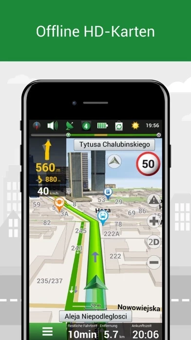
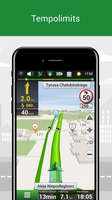
What is Navitel Navigator?
Navitel Navigator is precise offline navigation with free geosocial services and detailed maps of 66 countries. Try popular navigation for 7 days free! ADVANTAGES • Offline navigation. No Internet connection required for the use of the program and maps: No additional expenses on roaming or dependency on a mobile connection. • Offline maps of 66 countries are available for purchase. • Map subscription: Map purchase for a limited period (1 year) with prices starting at 10.99$. SPECIAL FEATURES • Navitel.Traffic. Information on all traffic jams in the covered area, available in real-time. • Navitel.Friends/Cloud. Messaging with friends, tracking their location, and routing towards them. Program settings and waypoints are stored in the NAVITEL cloud storage. Log in to Navitel.Friends/Cloud service using your social network profile (Facebook, Twitter) • Navitel.Weather. Weather forecast information for the next three days anywhere in the world. • Dynamic POI. Fuel prices, movie showtimes, and other useful information. • Navitel.Events. Road accidents, road works, speed cams, and other events marked on the map by users. • SpeedCam warnings. Information on radars, video recording cameras, and speed bumps. • 3D Mapping. Three-dimensional maps with texture and number of floors support. • 3D Road interchanges. Displaying multilevel road interchanges in 3D mode. • Lane Assist. Route calculations taking multilane traffic into account and visual prompts while following the route. • Mu...